Cafe nearby Barnet & Vrchovsky OG
Coronavirus disease (COVID-19) Situation
confirmed cases
6081287
deaths
22542
Austria
Cafe nearby Barnet & Vrchovsky OG
Barnet & Vrchovsky OG
Schottenfeldgasse 9, Wien Austria
contacts phone
:
+43
Latitude:
48.1977523
, Longitude:
16.3436116
read more
nearest Cafe
176 m
Ruby Marie Hotel & Bar
Kaiserstraße 2-4, Wien
Cafe
read more
315 m
13.5 E Mezzo
53, Lindengasse, Wien
Cafe
read more
467 m
FIRST fresh & tasty
Neubaugasse 1, Wien
Cafe
read more
600 m
CAFE SAN MARCO ***VIENNA***
Märzstraße 2, Wien
Cafe
read more
625 m
qualitätszeit
Gumpendorfer Straße 73/1, Wien
Cafe
read more
649 m
Café Hermann
Hermanngasse 27, Wien
Cafe
read more
656 m
Café Rafaelo
Märzstraße 9, Wien
Cafe
read more
677 m
ISIS Cafe-Restaurations und Warenhandel Nfg. KEG
Siebensterngasse 39, Wien
Cafe
read more
754 m
Cafe Berfin
Siebensterngasse 46, Wien
Cafe
read more
792 m
J. Hornig Kaffeebar
Siebensterngasse 29, Wien
Cafe
read more
797 m
Café Zipp
Burggasse 66, Wien
Cafe
read more
876 m
SzeGa GmbH
Schottenfeldgasse 85, Wien
Cafe
read more
917 m
Waffle & more
Wien
Cafe
read more
919 m
Simitchi
Gablenzgasse 5-13, Wien
Cafe
read more
924 m
Sir Harly's Tea
Mariahilfer Straße 45, Wien
Cafe
read more
958 m
burggasse 24 shop
Burggasse 24, Wien
Cafe
read more
970 m
Café Macao
Mariahilfer Straße 164, Wien
Cafe
read more
974 m
Cafe Grande
Reithofferplatz, Wien
Cafe
read more
983 m
Espresso Märzpark Tahil OG
Hütteldorfer Straße 6, Wien
Cafe
read more
986 m
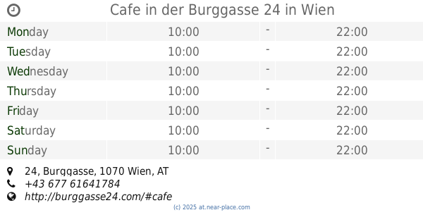
Cafe in der Burggasse 24
Burggasse 24, Wien
Cafe
read more
999 m
WHEEL - Simplify your Coffee
Siebensterngasse 16A, Wien
Cafe
read more
1.068 km
ERICH
Neustiftgasse 27, Wien
Cafe
read more
1.073 km
Sneak In
Siebensterngasse 12, Wien
Cafe
read more
1.073 km
Cafe Oben & Unten
Schönbrunner Straße 90, Wien
Cafe
read more
1.117 km
Das Möbel Cafe
Burggasse 10, Wien
Cafe
read more
📑
all categories
Accounting
Administrative area level 1
Administrative area level 2
Airport
Amusement park
Aquarium
Art gallery
Atm
Bakery
Bank
Bar
Beauty salon
Bicycle store
Book store
Bowling alley
Bus station
Cafe
Campground
Car dealer
Car rental
Car repair
Car wash
Casino
Cemetery
Church
City hall
Clothing store
Colloquial area
Convenience store
Country
Courthouse
Dentist
Department store
Doctor
Electrician
Electronics store
Embassy
Finance
Fire station
Florist
Food
Funeral home
Furniture store
Gas station
General contractor
Grocery or supermarket
Gym
Hair care
Hardware store
Health
Hindu Temple
Home goods store
Hospital
Insurance agency
Jewelry store
Laundry
Lawyer
Library
Light rail station
Liquor store
Local government office
Locality
Locksmith
Lodging
Meal delivery
Meal takeaway
Mosque
Movie rental
Movie theater
Moving company
Museum
Natural feature
Neighborhood
Night club
Painter
Park
Parking
Pet store
Pharmacy
Physiotherapist
Place of worship
Plumber
Point of interest
Police
Political
Post office
Premise
Real estate agency
Restaurant
Roofing contractor
Route
Rv park, camping
School
Shoe store
Shopping mall
Spa
Stadium
Storage
Store
Subpremise
Subway station
Supermarket
Synagogue
Taxi stand
Train station
Transit station
Travel agency
University
Veterinary care
Zoo
administrative area level 3
sublocality level 1
↑