Gas station nearby Pink Tankstelle
Austria
Gas station nearby Pink Tankstelle
Pink Tankstelle
Reitingerstraße 1, Steinhaus bei Wels Ausztria
contacts phone
:
+43
Latitude:
48.103943
, Longitude:
14.0396702
read more
nearest Gas station
4 m
PINK
Reitingerstraße 1, Steinhaus bei Wels
Gas station
read more
2.237 km
Diskont Seewirt
Steinhaus 54, Steinhaus bei Wels
Gas station
read more
2.259 km
Eckmair
Steinhaus 54, Steinhaus bei Wels
Gas station
read more
2.455 km
Lagerhaus Genol Tankstelle
Hauptstraße 22, Steinhaus bei Wels
Gas station
read more
3.18 km
Turmöl Quick
Sportplatzstraße 1, Sattledt
Gas station
read more
3.186 km
BP
Sportplatzstraße 1, Sattledt
Gas station
read more
3.546 km
BP Tankstelle Sattledter Tankstellenbetr. GmbH
Hauptstraße 2, Sattledt
Gas station
read more
3.546 km
Georg Norman Ohrenberger
Hauptstraße 2, Sattledt
Gas station
read more
4.129 km
BP
Voralpenkreuz A8, Sattledt
Gas station
read more
4.177 km
Lagerhaus Genol Tankstelle
Lindenstraße 30
Gas station
read more
4.18 km
Tankstelle Scheureder
Wollsberg 37, Wollsberg
Gas station
read more
4.181 km
AVIA Tankstelle
Wollsberg 37, Steinerkirchen an der Traun
Gas station
read more
6.795 km
Emin Bozkurt
Gunskirchener Straße 7, Wels
Gas station
read more
6.815 km
JET Tankstelle
Gunskirchnerstr. 1, Wels-West
Gas station
read more
6.817 km
Emin Bozkurt
Gunskirchener Straße 1, Wels
Gas station
read more
6.821 km
Jet
Haidlisse 1, Wels-West
Gas station
read more
6.854 km
maxi.tank
Gunskirchener Straße 7, Wels
Gas station
read more
6.872 km
OMV Tankstelle
Eisenfeldstraße 2, Wels
Gas station
read more
6.943 km
El Punjac E Ladung 22kW
Bahnhofstraße 33, Wels
Gas station
read more
7.168 km
Lagerhaus Genol Tankstelle
Sattledterstraße 11, Fischlham
Gas station
read more
7.315 km
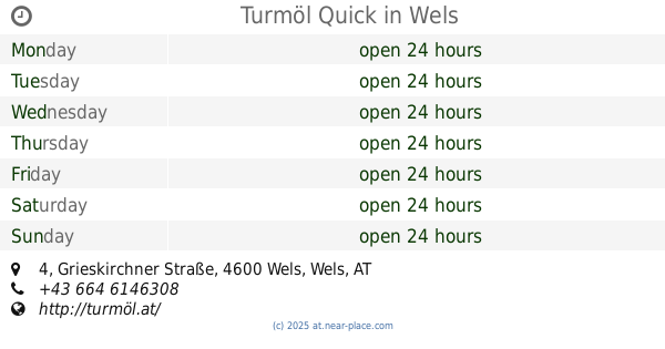
Turmöl Quick
Grieskirchner Straße 4, Wels
Gas station
read more
7.341 km
Siegfried Hennerbichler
Grieskirchner Straße 4, Wels
Gas station
read more
8.891 km
BP Tankstelle Anita Axmann
Linzer Straße 92a, Wels
Gas station
read more
11.454 km
BP
Linzer Straße 62, Marchtrenk
Gas station
read more
15.955 km
Quirchmayr
Eferdinger Straße 10, Wallern an der Trattnach
Gas station
read more
📑
all categories
Accounting
Administrative area level 1
Administrative area level 2
Airport
Amusement park
Aquarium
Art gallery
Atm
Bakery
Bank
Bar
Beauty salon
Bicycle store
Book store
Bowling alley
Bus station
Cafe
Campground
Car dealer
Car rental
Car repair
Car wash
Casino
Cemetery
Church
City hall
Clothing store
Colloquial area
Convenience store
Country
Courthouse
Dentist
Department store
Doctor
Electrician
Electronics store
Embassy
Finance
Fire station
Florist
Food
Funeral home
Furniture store
Gas station
General contractor
Grocery or supermarket
Gym
Hair care
Hardware store
Health
Hindu Temple
Home goods store
Hospital
Insurance agency
Jewelry store
Laundry
Lawyer
Library
Light rail station
Liquor store
Local government office
Locality
Locksmith
Lodging
Meal delivery
Meal takeaway
Mosque
Movie rental
Movie theater
Moving company
Museum
Natural feature
Neighborhood
Night club
Painter
Park
Parking
Pet store
Pharmacy
Physiotherapist
Place of worship
Plumber
Point of interest
Police
Political
Post office
Premise
Real estate agency
Restaurant
Roofing contractor
Route
Rv park, camping
School
Shoe store
Shopping mall
Spa
Stadium
Storage
Store
Subpremise
Subway station
Supermarket
Synagogue
Taxi stand
Train station
Transit station
Travel agency
University
Veterinary care
Zoo
administrative area level 3
sublocality level 1
↑