Bar nearby Club Diamond
Coronavirus disease (COVID-19) Situation
confirmed cases
6081287
deaths
22542
Austria
Bar nearby Club Diamond
Club Diamond
Kranebitter Allee 88, Innsbruck Österreich
contacts phone
:
+43
Latitude:
47.2638992
, Longitude:
11.3605083
read more
nearest Bar
Kupferpfandl
Kranebitter Allee 88, Innsbruck
Bar
read more
830 m
Runner Runner Innsbruck, Austria
Angergasse, Innsbruck
Bar
read more
1.513 km
Cafe GALAXY
Karwendelbögen 33-35, Innsbruck
Bar
read more
1.513 km
Bar/Cafe Karwendelbogen 33
Karwendelbögen 33, Innsbruck
Bar
read more
1.654 km
Monroes Bar
Innrain 87, Innsbruck
Bar
read more
1.795 km
Vaca Loca
Blasius-Hueber-Straße 16, Innsbruck
Bar
read more
2.025 km
Glockengießer
Bachgasse 14, Innsbruck
Bar
read more
2.396 km
Eckstein Café American Bar
Adolf-Pichler-Platz 2, Innsbruck
Bar
read more
2.421 km
Nachtschwärmer
Innsbrucker Straße 22-24, Innsbruck
Bar
read more
2.464 km
Cafe Bar Bierkrügerl
Innstraße 49, Innsbruck
Bar
read more
2.533 km
BRIXNERHAUS DA VINCENZO
Domplatz 3, Innsbruck
Bar
read more
2.539 km
Culinarium in the old town
Pfarrgasse 1, Innsbruck
Bar
read more
2.539 km
Culinarium in der Altstadt
Pfarrgasse 1, Innsbruck
Bar
read more
2.547 km
Limerick Bill's Irish Pub
Maria-Theresien-Straße 9, Innsbruck
Bar
read more
2.565 km
Bar Centrale
Maria-Theresien-Straße 31, Innsbruck
Bar
read more
2.58 km
Wettercafe
Leopoldstraße 2, Innsbruck
Bar
read more
2.639 km
Breakfast Club
Eduard-Wallnöfer-Platz 1, Innsbruck
Bar
read more
2.676 km
Gastgarten Zur Eiche
Innstraße 85, Innsbruck
Bar
read more
2.789 km
Verena’s Bar
Gießenweg 15, Völs
Bar
read more
2.813 km
Cafe Platzl
Mentlgasse 4, Innsbruck
Bar
read more
2.814 km
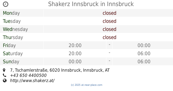
Shakerz Innsbruck
Tschamlerstraße 7, Innsbruck
Bar
read more
2.865 km
mfg Bar
Adamgasse 13, Innsbruck
Bar
read more
2.919 km
06 zerOsei
Universitätsstraße 15b, Innsbruck
Bar
read more
2.987 km
Bar Kir Royal
Sillgasse 11, Innsbruck
Bar
read more
3.032 km
Rote Laterne
Neurauthgasse 5, Innsbruck
Bar
read more
📑
all categories
Accounting
Administrative area level 1
Administrative area level 2
Airport
Amusement park
Aquarium
Art gallery
Atm
Bakery
Bank
Bar
Beauty salon
Bicycle store
Book store
Bowling alley
Bus station
Cafe
Campground
Car dealer
Car rental
Car repair
Car wash
Casino
Cemetery
Church
City hall
Clothing store
Colloquial area
Convenience store
Country
Courthouse
Dentist
Department store
Doctor
Electrician
Electronics store
Embassy
Finance
Fire station
Florist
Food
Funeral home
Furniture store
Gas station
General contractor
Grocery or supermarket
Gym
Hair care
Hardware store
Health
Hindu Temple
Home goods store
Hospital
Insurance agency
Jewelry store
Laundry
Lawyer
Library
Light rail station
Liquor store
Local government office
Locality
Locksmith
Lodging
Meal delivery
Meal takeaway
Mosque
Movie rental
Movie theater
Moving company
Museum
Natural feature
Neighborhood
Night club
Painter
Park
Parking
Pet store
Pharmacy
Physiotherapist
Place of worship
Plumber
Point of interest
Police
Political
Post office
Premise
Real estate agency
Restaurant
Roofing contractor
Route
Rv park, camping
School
Shoe store
Shopping mall
Spa
Stadium
Storage
Store
Subpremise
Subway station
Supermarket
Synagogue
Taxi stand
Train station
Transit station
Travel agency
University
Veterinary care
Zoo
administrative area level 3
sublocality level 1
↑