Bar nearby moksh cafe bar
Coronavirus disease (COVID-19) Situation
confirmed cases
6081287
deaths
22542
Austria
Bar nearby moksh cafe bar
moksh cafe bar
Schöpfstrasse 6b, Innsbruck Österreich
contacts phone
:
+43
Latitude:
47.2603817
, Longitude:
11.3912079
read more
nearest Bar
348 m
Wettercafe
Leopoldstraße 2, Innsbruck
Bar
read more
464 m
Cafe Platzl
Mentlgasse 4, Innsbruck
Bar
read more
465 m
Nachtschwärmer
Innsbrucker Straße 22-24, Innsbruck
Bar
read more
509 m
Breakfast Club
Eduard-Wallnöfer-Platz 1, Innsbruck
Bar
read more
524 m
Nargile Cafe (Mor Işıklı Masa)
Leopoldstraße 42a, Innsbruck
Bar
read more
556 m
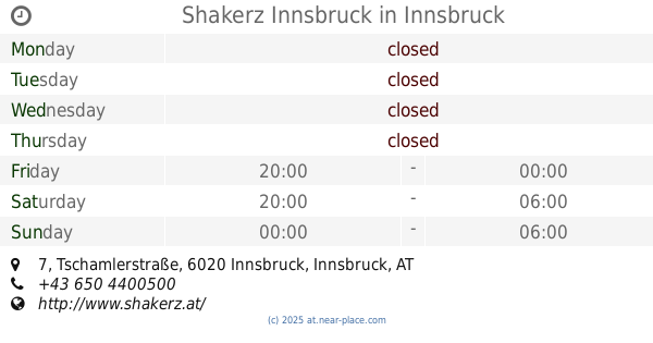
Shakerz Innsbruck
Tschamlerstraße 7, Innsbruck
Bar
read more
584 m
mfg Bar
Adamgasse 13, Innsbruck
Bar
read more
637 m
Bar Centrale
Maria-Theresien-Straße 31, Innsbruck
Bar
read more
673 m
Eckstein Café American Bar
Adolf-Pichler-Platz 2, Innsbruck
Bar
read more
714 m
Limerick Bill's Irish Pub
Maria-Theresien-Straße 9, Innsbruck
Bar
read more
757 m
Rote Laterne
Neurauthgasse 5, Innsbruck
Bar
read more
771 m
Jazzbar BRXN
Brixner Straße 4, Innsbruck
Bar
read more
953 m
Culinarium in der Altstadt
Pfarrgasse 1, Innsbruck
Bar
read more
953 m
Culinarium in the old town
Pfarrgasse 1, Innsbruck
Bar
read more
961 m
Ledio Nicntl
Brunecker Straße 3, Innsbruck
Bar
read more
964 m
Ayson Aksoy KEG
Museumstraße 34, Innsbruck
Bar
read more
969 m
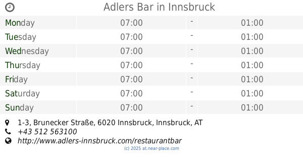
Adlers Bar
Brunecker Straße 1-3, Innsbruck
Bar
read more
1.059 km
LUCKY Sport-Wetten
Amraser Straße 6, Innsbruck
Bar
read more
1.07 km
Club Cavall
Amraser Straße 6, Innsbruck
Bar
read more
1.101 km
Bar Kir Royal
Sillgasse 11, Innsbruck
Bar
read more
1.112 km
06 zerOsei
Universitätsstraße 15b, Innsbruck
Bar
read more
1.119 km
Jellyfish Music.Bar
Ingenieur-Etzel-Straße 13, Innsbruck
Bar
read more
1.148 km
PlanB
Ingenieur-Etzel-Straße 15, Innsbruck
Bar
read more
1.177 km
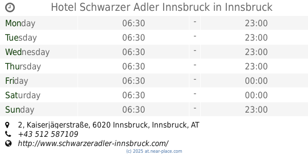
Hotel Schwarzer Adler Innsbruck
Kaiserjägerstraße 2, Innsbruck
Bar
read more
1.229 km
Down Under
Ingenieur-Etzel-Straße 22, Innsbruck
Bar
read more
📑
all categories
Accounting
Administrative area level 1
Administrative area level 2
Airport
Amusement park
Aquarium
Art gallery
Atm
Bakery
Bank
Bar
Beauty salon
Bicycle store
Book store
Bowling alley
Bus station
Cafe
Campground
Car dealer
Car rental
Car repair
Car wash
Casino
Cemetery
Church
City hall
Clothing store
Colloquial area
Convenience store
Country
Courthouse
Dentist
Department store
Doctor
Electrician
Electronics store
Embassy
Finance
Fire station
Florist
Food
Funeral home
Furniture store
Gas station
General contractor
Grocery or supermarket
Gym
Hair care
Hardware store
Health
Hindu Temple
Home goods store
Hospital
Insurance agency
Jewelry store
Laundry
Lawyer
Library
Light rail station
Liquor store
Local government office
Locality
Locksmith
Lodging
Meal delivery
Meal takeaway
Mosque
Movie rental
Movie theater
Moving company
Museum
Natural feature
Neighborhood
Night club
Painter
Park
Parking
Pet store
Pharmacy
Physiotherapist
Place of worship
Plumber
Point of interest
Police
Political
Post office
Premise
Real estate agency
Restaurant
Roofing contractor
Route
Rv park, camping
School
Shoe store
Shopping mall
Spa
Stadium
Storage
Store
Subpremise
Subway station
Supermarket
Synagogue
Taxi stand
Train station
Transit station
Travel agency
University
Veterinary care
Zoo
administrative area level 3
sublocality level 1
↑