Bar nearby Rox Musicbar Linz
Austria
Bar nearby Rox Musicbar Linz
Rox Musicbar Linz
Graben 18, Linz Østrig
contacts phone
:
+43
Latitude:
48.3052232
, Longitude:
14.2899332
read more
nearest Bar
61 m
Lennox
Marienstraße 2a, Linz
Bar
read more
212 m
OBEN
OK-Platz 1, Linz
Bar
read more
215 m
Bar Neuf
Rathausgasse 9, Linz
Bar
read more
219 m
Meixner-Rieger KEG
Landstraße 12, Linz
Bar
read more
219 m
bayabar
Landstraße 12, Linz
Bar
read more
231 m
Bar Keintzel
Rathausgasse 3, Linz
Bar
read more
268 m
Leopoldistüberl der Beer Buddies Brewing Company
Adlergasse 6, Linz
Bar
read more
296 m
Sisi-Top
Untere Donaulände 8, Linz
Bar
read more
347 m
Exxtrablatt
Spittelwiese 6, Linz
Bar
read more
352 m
Klaus & Wein
Harrachstraße 10, Linz
Bar
read more
359 m
Diego's Vinothek
Bischofstraße 4, Linz
Bar
read more
383 m
Rooftop 7
Herrenstraße 11, Linz
Bar
read more
384 m
Aps
Hahnengasse 5, Linz
Bar
read more
399 m
Cafe Aquarium
Altstadt 22, Linz
Bar
read more
434 m
Linzerl
Hofberg 5, Linz
Bar
read more
440 m
Tempelbar
Hofberg 6, Linz
Bar
read more
541 m
Cafe Bar Mezzanin
Johann-Konrad-Vogel-Straße 11, Linz
Bar
read more
548 m
Buffet Waltraud
Harrachstraße 33, Linz
Bar
read more
626 m
Easy Bar
Baumbachstraße 14, Linz
Bar
read more
630 m
Alambha Coffee
Mozartstraße 44, Linz
Bar
read more
692 m
Wilhelm Morawa
Starhembergstraße 11, Linz
Bar
read more
732 m
KÉ café & bar
Untere Donaulände 9, Linz
Bar
read more
850 m
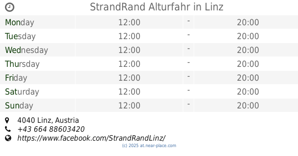
StrandRand Alturfahr
Linz
Bar
read more
899 m
ADMIRAL Filiale
Rudolfstraße 4-6, Linz
Bar
read more
964 m
Gerüchte Küche - Geselligkeitsverein Frisch und Froh
Marktplatz 18, Linz
Bar
read more
📑
all categories
Accounting
Administrative area level 1
Administrative area level 2
Airport
Amusement park
Aquarium
Art gallery
Atm
Bakery
Bank
Bar
Beauty salon
Bicycle store
Book store
Bowling alley
Bus station
Cafe
Campground
Car dealer
Car rental
Car repair
Car wash
Casino
Cemetery
Church
City hall
Clothing store
Colloquial area
Convenience store
Country
Courthouse
Dentist
Department store
Doctor
Electrician
Electronics store
Embassy
Finance
Fire station
Florist
Food
Funeral home
Furniture store
Gas station
General contractor
Grocery or supermarket
Gym
Hair care
Hardware store
Health
Hindu Temple
Home goods store
Hospital
Insurance agency
Jewelry store
Laundry
Lawyer
Library
Light rail station
Liquor store
Local government office
Locality
Locksmith
Lodging
Meal delivery
Meal takeaway
Mosque
Movie rental
Movie theater
Moving company
Museum
Natural feature
Neighborhood
Night club
Painter
Park
Parking
Pet store
Pharmacy
Physiotherapist
Place of worship
Plumber
Point of interest
Police
Political
Post office
Premise
Real estate agency
Restaurant
Roofing contractor
Route
Rv park, camping
School
Shoe store
Shopping mall
Spa
Stadium
Storage
Store
Subpremise
Subway station
Supermarket
Synagogue
Taxi stand
Train station
Transit station
Travel agency
University
Veterinary care
Zoo
administrative area level 3
sublocality level 1
↑