places in Bludenz
Austria
Bludenz
Bludenz
Administrative Region:
Vorarlberg
population:
14 397
calling code:
+43-5552
postcode:
6700
Location on the map of Austria
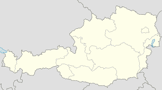
Bludenz
Church
Kirchenbeitragsstelle Bludenz
Färberstraße 10, Bludenz
Church
read more
Heilige Anna
Klostertalerstraße, Bludenz
Church
read more
Wallfahrtskapelle
Untere Venserstraße 117, Vandans
Church
read more
Pfarramt
Matin 46, Bürserberg
Church
read more
Bludenz - Heilig Kreuz
Sankt-Peter-Straße 2, Bludenz
Church
read more
Pfarramt
Schulstraße 6, Bürs
Church
read more
Friedenskirche
Schulstraße 6, Bürs
Church
read more
Sankt Leonhard
Sankt Leonhard, Bludenz
Church
read more
Sankt Josef
Matin .280, Bürserberg
Church
read more
Spitalkirche Zur Heiligen Dreifaltigkeit
Kirchgasse, Bludenz
Church
read more
Neuapostolische Kirche Österreich, Gemeinde Bludenz
Schmittenstraße 22, Bludenz
Church
read more
Sankt Antonius von Padua
Rungelin, Bludenz
Church
read more
Laurentius Kirche
Schloß-Gayenhof-Platz 6, Bludenz
Church
read more
Pfarrvikariatskirche zur Heiligen Dreifaltigkeit
Oberbings, Bludenz
Church
read more
Zur Mariä Geburt
Stallehr, Lorüns
Church
read more
Jewelry store
Uhren Schmuck Dalus
Almteilweg 1, Bürs
Jewelry store
read more
Dalus
Almteilweg 1, Bürs
Jewelry store
read more
Neumeister die Schmuckschmiede
Werdenbergerstraße 38, Bludenz
Jewelry store
read more
Bijou Brigitte
Almteilweg 1, Bürs
Jewelry store
read more
Plakolm Uhren & Juwelen GmbH
Werdenbergerstraße 31, Bludenz
Jewelry store
read more
Movie theater
Kino-Bludenz
Wichnerstraße 15, Bludenz
Movie theater
read more
Neighborhood
Institut Alternative Lebenshilfe
Institut Alternative Lebenshilfe, Judavollastraße 24, Bürs
Neighborhood
read more
Pharmacy
Central Apotheke Mag.pharm. Petra Ertl-Vallaster e.U.
Wichnerstraße 36, Bludenz
Pharmacy
read more
dm drogerie markt GmbH
Herrenau 6, Bürs
Pharmacy
read more
Apotheke Bludenz Stadt - Rat&Tat Apotheke
Werdenbergerstraße 24-26, Bludenz
Pharmacy
read more
Rosenegg pharmacy Bürs
Aulandweg 2a, Bürs
Pharmacy
read more
📑
Bludenz all categories
Accounting
Administrative area level 2
Art gallery
Bakery
Bank
Bar
Beauty salon
Bicycle store
Book store
Bowling alley
Bus station
Cafe
Campground
Car dealer
Car rental
Car repair
Car wash
Cemetery
Church
Clothing store
Courthouse
Dentist
Doctor
Electrician
Electronics store
Embassy
Finance
Fire station
Florist
Funeral home
Furniture store
Gas station
General contractor
Grocery or supermarket
Gym
Hair care
Hardware store
Health
Home goods store
Hospital
Insurance agency
Jewelry store
Laundry
Lawyer
Library
Liquor store
Local government office
Locality
Locksmith
Lodging
Meal delivery
Meal takeaway
Mosque
Movie theater
Moving company
Museum
Natural feature
Neighborhood
Painter
Park
Parking
Pet store
Pharmacy
Physiotherapist
Place of worship
Plumber
Point of interest
Police
Post office
Premise
Real estate agency
Restaurant
Roofing contractor
Route
School
Shoe store
Shopping mall
Spa
Store
Subpremise
Supermarket
Taxi stand
Train station
Travel agency
University
Veterinary care
administrative area level 3
sublocality level 1
↑