Cafe nearby Mokador
Austria
Cafe nearby Mokador
Mokador
Neubaugürtel 27, Wien Østrig
contacts phone
:
+43
Latitude:
48.2018113
, Longitude:
16.3369869
read more
nearest Cafe
107 m
Witz Elfriede GesmbH
Neubaugürtel 42, Wien
Cafe
read more
110 m
CAFE SAN MARCO ***VIENNA***
Märzstraße 2, Wien
Cafe
read more
182 m
Café Verona
Märzstraße 3, Wien
Cafe
read more
221 m
Café Rafaelo
Märzstraße 9, Wien
Cafe
read more
254 m
Simitchi
Gablenzgasse 5-13, Wien
Cafe
read more
466 m
Espresso Märzpark Tahil OG
Hütteldorfer Straße 6, Wien
Cafe
read more
611 m
SzeGa GmbH
Schottenfeldgasse 85, Wien
Cafe
read more
636 m
Cafe Grande
Reithofferplatz, Wien
Cafe
read more
642 m
Ruby Marie Hotel & Bar
Kaiserstraße 2-4, Wien
Cafe
read more
644 m
Café Derwisch
Lerchenfelder Gürtel 29, Wien
Cafe
read more
710 m
Cafe-Bar Angelique
Lerchenfelder Gürtel 40, Wien
Cafe
read more
738 m
13.5 E Mezzo
53, Lindengasse, Wien
Cafe
read more
760 m
Café Hermann
Hermanngasse 27, Wien
Cafe
read more
765 m
Sasani & Mohsenzadeh Gesellschaft m.b.H.
Lerchenfelder Straße 148, Wien
Cafe
read more
833 m
Melangerie Bistro & Caffeterie
Lerchenfelder Straße 94-98, Wien
Cafe
read more
844 m
Café Zipp
Burggasse 66, Wien
Cafe
read more
913 m
GERTI-Café
Neustiftgasse 73-75, Wien
Cafe
read more
969 m
ISIS Cafe-Restaurations und Warenhandel Nfg. KEG
Siebensterngasse 39, Wien
Cafe
read more
969 m
Kaffeerestaurant Nil
Siebensterngasse 39, Wien
Cafe
read more
977 m
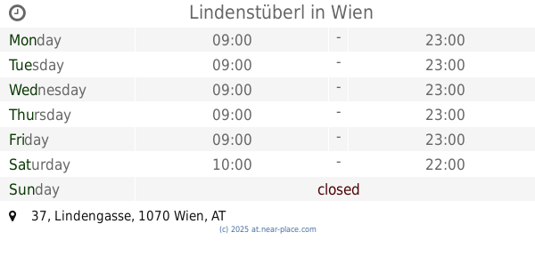
Lindenstüberl
Lindengasse 37, Wien
Cafe
read more
1.012 km
FIRST fresh & tasty
Neubaugasse 1, Wien
Cafe
read more
1.081 km
Café Antique
Kardinal-Rauscher-Platz 3, Wien
Cafe
read more
1.17 km
Radovanlija & Co KG
Panikengasse 20, Wien
Cafe
read more
1.17 km
Café-Restaurant Hold
Josefstädter Straße 50, Wien
Cafe
read more
1.296 km
GREEN HAUSE
1150 Wien Schwendermarkt nur, 19, 1150
Cafe
read more
📑
all categories
Accounting
Administrative area level 1
Administrative area level 2
Airport
Amusement park
Aquarium
Art gallery
Atm
Bakery
Bank
Bar
Beauty salon
Bicycle store
Book store
Bowling alley
Bus station
Cafe
Campground
Car dealer
Car rental
Car repair
Car wash
Casino
Cemetery
Church
City hall
Clothing store
Colloquial area
Convenience store
Country
Courthouse
Dentist
Department store
Doctor
Electrician
Electronics store
Embassy
Finance
Fire station
Florist
Food
Funeral home
Furniture store
Gas station
General contractor
Grocery or supermarket
Gym
Hair care
Hardware store
Health
Hindu Temple
Home goods store
Hospital
Insurance agency
Jewelry store
Laundry
Lawyer
Library
Light rail station
Liquor store
Local government office
Locality
Locksmith
Lodging
Meal delivery
Meal takeaway
Mosque
Movie rental
Movie theater
Moving company
Museum
Natural feature
Neighborhood
Night club
Painter
Park
Parking
Pet store
Pharmacy
Physiotherapist
Place of worship
Plumber
Point of interest
Police
Political
Post office
Premise
Real estate agency
Restaurant
Roofing contractor
Route
Rv park, camping
School
Shoe store
Shopping mall
Spa
Stadium
Storage
Store
Subpremise
Subway station
Supermarket
Synagogue
Taxi stand
Train station
Transit station
Travel agency
University
Veterinary care
Zoo
administrative area level 3
sublocality level 1
↑