Cemetery nearby Friedhof Schöngrabern
Coronavirus disease (COVID-19) Situation
confirmed cases
6081287
deaths
22542
Austria
Cemetery nearby Friedhof Schöngrabern
Friedhof Schöngrabern
Schöngrabern 83, Schöngrabern Österreich
contacts phone
:
+43
Latitude:
48.6036084
, Longitude:
16.0563171
read more
nearest Cemetery
5.529 km
Friedhofsverwaltung
Marchatsteig 389, Gemeinde Hollabrunn
Cemetery
read more
5.621 km
Friedhof Hollabrunn
Hollabrunn
Cemetery
read more
5.621 km
Friedhof Hollabrunn
Gemeinde Hollabrunn
Cemetery
read more
5.89 km
Советское воинское захоронение
Jahnstraße 2020, Gemeinde Hollabrunn
Cemetery
read more
6.612 km
Friedhof Sonnberg
Sonnberg
Cemetery
read more
6.659 km
Jüdischer Friedhof Hollabrunn
Steinfeldgasse 360, Gemeinde Hollabrunn
Cemetery
read more
8.955 km
Friedhof Fahndorf
Österreich
Cemetery
read more
19.899 km
Kattauer Friedhof
Austria
Cemetery
read more
21.402 km
Tierfriedhof Waldesruh
Sierndorf
Cemetery
read more
21.435 km
Wiener Tierfriedhof Waldesruh
Weinviertler Schnellstraße, Sierndorf
Cemetery
read more
23.645 km
Stein-Schindler
Zissersdorf 37, Zissersdorf
Cemetery
read more
24.61 km
Friedhof
Гемайнде, Meiseldorf
Cemetery
read more
26.433 km
Cimitero Militare Italiano Sigmundsherberg
Kainreith 76, Kainreith
Cemetery
read more
27.107 km
Friedhof Weitersfeld
Österreich
Cemetery
read more
27.387 km
Friedhof Pleißing
Österreich
Cemetery
read more
27.622 km
Friedhof Walkenstein
Walkenstein 45, Walkenstein
Cemetery
read more
28.16 km
Friedhof Spillern
Wiesener Straße 100, Spillern
Cemetery
read more
42.691 km
Friedhof Kahlenbergerdorf
Willibald-Fischer-Weg, Wien
Cemetery
read more
43.981 km
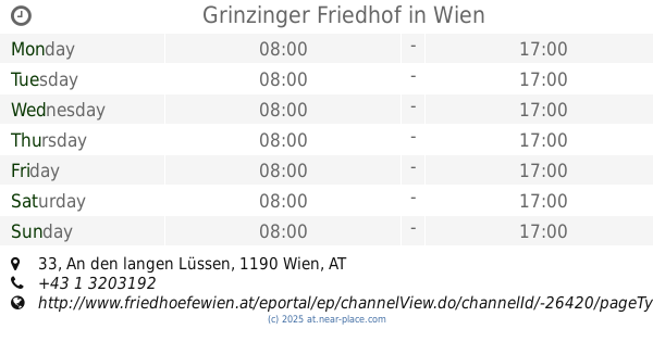
Grinzinger Friedhof
An den langen Lüssen 33, Wien
Cemetery
read more
47.922 km
Jüdischer Friedhof Rossau
Alsergrund
Cemetery
read more
47.949 km
Jüdischer Friedhof Seegasse
Seegasse 9, Wien
Cemetery
read more
49.02 km
Marmorama Bau- u. Handelsgesellschaft m.b.H.
Börseplatz 6, Wien
Cemetery
read more
49.714 km
Friedhof Ober-Sankt-Veit
Gemeindeberggasse 73, Wien
Cemetery
read more
50.357 km
Sysoon Austria
Kärntner Ring 9, Wien
Cemetery
read more
55.303 km
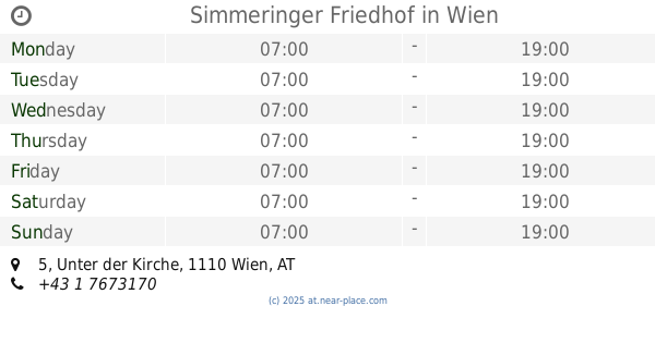
Simmeringer Friedhof
Unter der Kirche 5, Wien
Cemetery
read more
📑
all categories
Accounting
Administrative area level 1
Administrative area level 2
Airport
Amusement park
Aquarium
Art gallery
Atm
Bakery
Bank
Bar
Beauty salon
Bicycle store
Book store
Bowling alley
Bus station
Cafe
Campground
Car dealer
Car rental
Car repair
Car wash
Casino
Cemetery
Church
City hall
Clothing store
Colloquial area
Convenience store
Country
Courthouse
Dentist
Department store
Doctor
Electrician
Electronics store
Embassy
Finance
Fire station
Florist
Food
Funeral home
Furniture store
Gas station
General contractor
Grocery or supermarket
Gym
Hair care
Hardware store
Health
Hindu Temple
Home goods store
Hospital
Insurance agency
Jewelry store
Laundry
Lawyer
Library
Light rail station
Liquor store
Local government office
Locality
Locksmith
Lodging
Meal delivery
Meal takeaway
Mosque
Movie rental
Movie theater
Moving company
Museum
Natural feature
Neighborhood
Night club
Painter
Park
Parking
Pet store
Pharmacy
Physiotherapist
Place of worship
Plumber
Point of interest
Police
Political
Post office
Premise
Real estate agency
Restaurant
Roofing contractor
Route
Rv park, camping
School
Shoe store
Shopping mall
Spa
Stadium
Storage
Store
Subpremise
Subway station
Supermarket
Synagogue
Taxi stand
Train station
Transit station
Travel agency
University
Veterinary care
Zoo
administrative area level 3
sublocality level 1
↑