Church nearby Bethel, Biserica Penticostală Română, Freie Christengemeinde-Pfingstgemeinde, Freikirchen Österreich
Coronavirus disease (COVID-19) Situation
confirmed cases
6081287
deaths
22542
Austria
Church nearby Bethel, Biserica Penticostală Română, Freie Christengemeinde-Pfingstgemeinde, Freikirchen Österreich
Bethel, Biserica Penticostală Română, Freie Christengemeinde-Pfingstgemeinde, Freikirchen Österreich
Wiener Bundesstraße 190f Austria
contacts phone
:
+43
Latitude:
48.230728
, Longitude:
14.2192189
read more
nearest Church
Bethel FCGÖ
Wiener Bundesstraße 190f
Church
read more
12 m
Kirche freie Christengemeinde Pfingstgemeimde Betel
Wiener Bundesstraße 190f, Traun
Church
read more
1.164 km
Friedhofskapelle Kremstalstraße
Georg Grinninger-Straße 1663/1, Traun
Church
read more
1.719 km
Kirchenbeitragsstelle Traun
Johann-Roithner-Straße 3, Traun
Church
read more
1.779 km
Freikirche Traun
Tischlerstraße 27, Traun
Church
read more
1.8 km
Stadtpfarrkirche Traun
Kirchenplatz
Church
read more
1.845 km
Pfarramt - Oedt-St. Josef
Randweg 6
Church
read more
1.853 km
Sankt Josef (Traun-Oedt)
Radweg 6, Traun
Church
read more
1.863 km
Evangelische Pfarrgemeinde A.B. Traun
Doktor-Knechtl-Straße 31, Traun
Church
read more
1.863 km
Pfarramt
Kirchenplatz 1, Traun
Church
read more
2.13 km
Römisch-katholische Kooperator
Langholzfeld, Pasching
Church
read more
3.279 km
Sankt Martin
Schubertstraße 10, Traun
Church
read more
3.677 km
Russenkirche
Prunerstraße 5, Traun
Church
read more
3.695 km
Bruder Klaus
Haidfeldstraße 27, Leonding
Church
read more
3.695 km
Caritas d.Diözese Linz
Haidfeldstraße 27
Church
read more
3.706 km
Kath. Pfarrkirche Bruder Klaus
Haidfeldstraße 27
Church
read more
3.789 km
Autobahnkirche
Kirchenstraße 1, Ansfelden
Church
read more
3.972 km
Evangelische Pfarrkirche A. B. Traun
Adalbert-Stifter-Straße 15, Ansfelden
Church
read more
4.879 km
Pfarramt Berg
Mayr-zu-Berg-Straße 24, Ansfelden
Church
read more
5.085 km
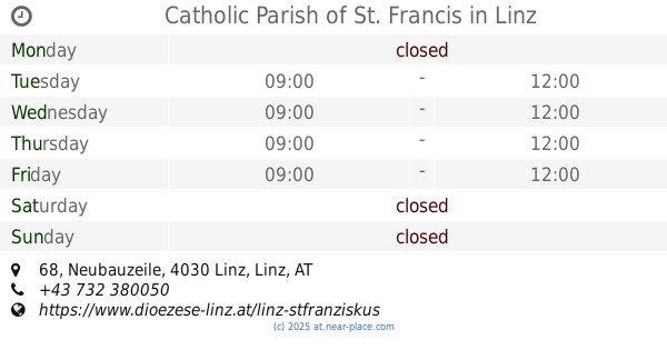
Catholic Parish of St. Francis
Neubauzeile 68, Linz
Church
read more
5.125 km
Pfarrkirche Sankt Franziskus
Neubauzeile 68, Linz
Church
read more
5.199 km
Rhema Gemeindezentrum
Angererhofweg 3, Linz
Church
read more
5.756 km
Jehovas Zeugen
Gerstmayrstraße 36, Leonding
Church
read more
6.104 km
Heilige Dreifaltigkeit
Schiffmannstraße 1, Linz
Church
read more
6.106 km
Biserica Ortodoxă
Wieningerstraße 14, Linz
Church
read more
📑
all categories
Accounting
Administrative area level 1
Administrative area level 2
Airport
Amusement park
Aquarium
Art gallery
Atm
Bakery
Bank
Bar
Beauty salon
Bicycle store
Book store
Bowling alley
Bus station
Cafe
Campground
Car dealer
Car rental
Car repair
Car wash
Casino
Cemetery
Church
City hall
Clothing store
Colloquial area
Convenience store
Country
Courthouse
Dentist
Department store
Doctor
Electrician
Electronics store
Embassy
Finance
Fire station
Florist
Food
Funeral home
Furniture store
Gas station
General contractor
Grocery or supermarket
Gym
Hair care
Hardware store
Health
Hindu Temple
Home goods store
Hospital
Insurance agency
Jewelry store
Laundry
Lawyer
Library
Light rail station
Liquor store
Local government office
Locality
Locksmith
Lodging
Meal delivery
Meal takeaway
Mosque
Movie rental
Movie theater
Moving company
Museum
Natural feature
Neighborhood
Night club
Painter
Park
Parking
Pet store
Pharmacy
Physiotherapist
Place of worship
Plumber
Point of interest
Police
Political
Post office
Premise
Real estate agency
Restaurant
Roofing contractor
Route
Rv park, camping
School
Shoe store
Shopping mall
Spa
Stadium
Storage
Store
Subpremise
Subway station
Supermarket
Synagogue
Taxi stand
Train station
Transit station
Travel agency
University
Veterinary care
Zoo
administrative area level 3
sublocality level 1
↑