Clothing store nearby Fantasy fashion store
Austria
Clothing store nearby Fantasy fashion store
Fantasy fashion store
Gruberstraße 533/2, Linz Österreich
contacts phone
:
+43
Latitude:
48.3117692
, Longitude:
14.3000954
read more
nearest Clothing store
885 m
C.U.L.T. - Boutique
Block A, Paul-Hahn-Straße 1-3, Linz
Clothing store
read more
1.055 km
Goldhauben Webe
Reindlstraße 41, Linz
Clothing store
read more
1.102 km
TSE POTALA Tibet Shop
Graben 28, Linz
Clothing store
read more
1.103 km
Alpis & Gallys
Graben 19a, Linz
Clothing store
read more
1.134 km
Sanfte Pflege
Rathausgasse 2, Linz
Clothing store
read more
1.135 km
Sorvella Parfümerie
Graben 25, Linz
Clothing store
read more
1.179 km
Casamoda Linz
Graben 36, Linz
Clothing store
read more
1.201 km
Avalon
Domgasse 18, Linz
Clothing store
read more
1.216 km
Intimissimi
Landstraße 11, Linz
Clothing store
read more
1.229 km
Street One
Landstraße 17-25, Linz
Clothing store
read more
1.238 km
City Outlet Linz
Landstraße 17-25, Linz
Clothing store
read more
1.238 km
Esprit
Passage Kaufhaus, Landstraße 17-25, Linz
Clothing store
read more
1.238 km
Esprit HandelsgesmbH
Landstraße 17, Linz
Clothing store
read more
1.238 km
Hunkemöller
Landstraße 17-25, Linz
Clothing store
read more
1.238 km
Tally Weijl
Landstraße 7, Linz
Clothing store
read more
1.244 km
H&M
Landstraße 4-6, Linz
Clothing store
read more
1.254 km
Nägele & Strubell
4, Promenade, Linz
Clothing store
read more
1.254 km
MANGO
Landstraße 12, Linz
Clothing store
read more
1.257 km
Olsen-Moden GmbH & Co Nfg. KG
Landstraße 17, Linz
Clothing store
read more
1.259 km
MATASE Kindermode
Landstraße 12, Linz
Clothing store
read more
1.26 km
Gloriette Fashion GmbH
Landstraße 12, Linz
Clothing store
read more
1.264 km
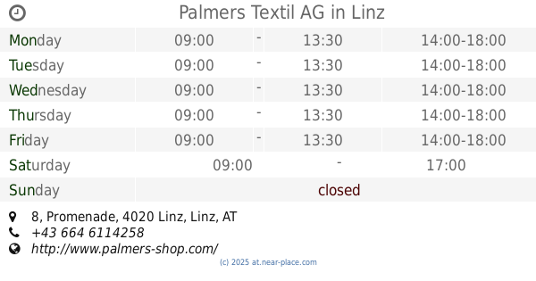
Palmers Textil AG
Promenade 8, Linz
Clothing store
read more
1.267 km
Kleider Bauer
Landstraße 18, Linz
Clothing store
read more
1.273 km
Triumph-Shop
Landstraße 22, Linz
Clothing store
read more
1.327 km
Thalbauer Harriette Lieb KG
Spittelwiese 4, Linz
Clothing store
read more
📑
all categories
Accounting
Administrative area level 1
Administrative area level 2
Airport
Amusement park
Aquarium
Art gallery
Atm
Bakery
Bank
Bar
Beauty salon
Bicycle store
Book store
Bowling alley
Bus station
Cafe
Campground
Car dealer
Car rental
Car repair
Car wash
Casino
Cemetery
Church
City hall
Clothing store
Colloquial area
Convenience store
Country
Courthouse
Dentist
Department store
Doctor
Electrician
Electronics store
Embassy
Finance
Fire station
Florist
Food
Funeral home
Furniture store
Gas station
General contractor
Grocery or supermarket
Gym
Hair care
Hardware store
Health
Hindu Temple
Home goods store
Hospital
Insurance agency
Jewelry store
Laundry
Lawyer
Library
Light rail station
Liquor store
Local government office
Locality
Locksmith
Lodging
Meal delivery
Meal takeaway
Mosque
Movie rental
Movie theater
Moving company
Museum
Natural feature
Neighborhood
Night club
Painter
Park
Parking
Pet store
Pharmacy
Physiotherapist
Place of worship
Plumber
Point of interest
Police
Political
Post office
Premise
Real estate agency
Restaurant
Roofing contractor
Route
Rv park, camping
School
Shoe store
Shopping mall
Spa
Stadium
Storage
Store
Subpremise
Subway station
Supermarket
Synagogue
Taxi stand
Train station
Transit station
Travel agency
University
Veterinary care
Zoo
administrative area level 3
sublocality level 1
↑