Gas station nearby Milo Wolfhalden AG
Coronavirus disease (COVID-19) Situation
confirmed cases
6081287
deaths
22542
Austria
Gas station nearby Milo Wolfhalden AG
Milo Wolfhalden AG
Guggen, Wolfhalden Austria
contacts phone
:
+43
Latitude:
47.4455117
, Longitude:
9.5440021
read more
nearest Gas station
889 m
BP
Rosentalstrasse 1, Heiden
Gas station
read more
2.172 km
Mr. Hans Ueli Hohl
Rutlenstrasse 43, Oberegg
Gas station
read more
2.614 km
Agrola
Dorfstrasse 11, Oberegg
Gas station
read more
3.958 km
Shell
Hauptstrasse 30, Staad
Gas station
read more
3.971 km
Migrol Tankstelle
Hauptstrasse 2, Thal
Gas station
read more
4.168 km
Spurt
Appenzellerstrasse 1, Rheineck
Gas station
read more
4.172 km
Ruedi Rüssel
Hauptstrasse 76, Rheineck
Gas station
read more
4.229 km
Coop Pronto Rheineck
Rorschacherstrasse 92, Rheineck
Gas station
read more
4.411 km
Kollers Autowösch
Knotternstrasse, Staad
Gas station
read more
4.42 km
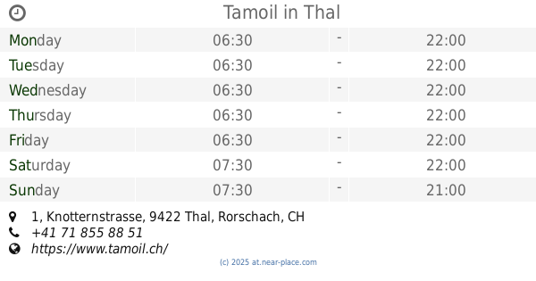
Tamoil
Knotternstrasse 1, Thal
Gas station
read more
4.529 km
Luomed GmbH
Dorf 78, Walzenhausen
Gas station
read more
4.691 km
Ebni-Tankstelle Wald
Ebni 626, Wald
Gas station
read more
4.707 km
Spurt Tankstelle, Zahlung Nur Mit Karte Möglich
Säge 205, Walzenhausen
Gas station
read more
4.741 km
AVIA
Autogrill Schweiz, A1, Sankt Margrethen
Gas station
read more
4.815 km
Eni
Restoroute St. Margrethen, Sankt Margrethen
Gas station
read more
4.82 km
Service Area St.Margrethen North
Nationalstrasse A1, Sankt Margrethen
Gas station
read more
5.116 km
Spurt
Obereggerstrasse 12, Berneck
Gas station
read more
6.272 km
Avia-shop
Hauptstrasse 65, Balgach
Gas station
read more
6.292 km
Garage Kaufmann AG
Auerstrasse 34, Berneck
Gas station
read more
8.389 km
Thomas Eugster Heizöl & Diesel
Galerieweg 8, Widnau
Gas station
read more
8.435 km
BP
Reichshofstraße, Lustenau
Gas station
read more
10.285 km
BP
Tramstrasse 19, Diepoldsau
Gas station
read more
10.795 km
JET Tankstelle
Rheinstraße 99, Hard
Gas station
read more
14.324 km
Freie Tankstelle
Eichaustrasse 8A, Oberriet
Gas station
read more
15.295 km
DISK Tankstelle
Arlbergstraße 6, Dornbirn
Gas station
read more
📑
all categories
Accounting
Administrative area level 1
Administrative area level 2
Airport
Amusement park
Aquarium
Art gallery
Atm
Bakery
Bank
Bar
Beauty salon
Bicycle store
Book store
Bowling alley
Bus station
Cafe
Campground
Car dealer
Car rental
Car repair
Car wash
Casino
Cemetery
Church
City hall
Clothing store
Colloquial area
Convenience store
Country
Courthouse
Dentist
Department store
Doctor
Electrician
Electronics store
Embassy
Finance
Fire station
Florist
Food
Funeral home
Furniture store
Gas station
General contractor
Grocery or supermarket
Gym
Hair care
Hardware store
Health
Hindu Temple
Home goods store
Hospital
Insurance agency
Jewelry store
Laundry
Lawyer
Library
Light rail station
Liquor store
Local government office
Locality
Locksmith
Lodging
Meal delivery
Meal takeaway
Mosque
Movie rental
Movie theater
Moving company
Museum
Natural feature
Neighborhood
Night club
Painter
Park
Parking
Pet store
Pharmacy
Physiotherapist
Place of worship
Plumber
Point of interest
Police
Political
Post office
Premise
Real estate agency
Restaurant
Roofing contractor
Route
Rv park, camping
School
Shoe store
Shopping mall
Spa
Stadium
Storage
Store
Subpremise
Subway station
Supermarket
Synagogue
Taxi stand
Train station
Transit station
Travel agency
University
Veterinary care
Zoo
administrative area level 3
sublocality level 1
↑