Lodging nearby Touristenverein 'die Naturfreunde' Ortsgruppe Neunkirchen
Austria
Lodging nearby Touristenverein 'die Naturfreunde' Ortsgruppe Neunkirchen
Touristenverein 'die Naturfreunde' Ortsgruppe Neunkirchen
Flatzer Hütte, Ternitz Österreich
contacts phone
:
+43
Latitude:
47.7342436
, Longitude:
16.0225296
read more
nearest Lodging
1.349 km
Gasthof Geiger - Zum St. Johannerhof
Puchberger Straße 18, Ternitz
Lodging
read more
1.496 km
Pension Gfiederblick Heurigenrestaurant Wadowiec
Franz Woltron-Gasse 1, Ternitz
Lodging
read more
1.934 km
Anna Trenk
Rohrbacherstraße 11, Ternitz
Lodging
read more
2.095 km
Gasthof Faseth
Forstnerweg 1, Ternitz
Lodging
read more
2.179 km
Neunkirchner Naturfreundehaus
1420/13,, Gösinggasse 1420/13
Lodging
read more
2.361 km
Eric Schwertführer
Hauptstraße 14, Ternitz
Lodging
read more
2.812 km
Gasthaus Woltron Maria Ofenböck
Raglitzer Straße 116
Lodging
read more
3.326 km
Norbert Strebinger
Siedinger Straße 9
Lodging
read more
3.857 km
Gasthaus Kum a hin
Pottschacher Straße 65, Ternitz
Lodging
read more
3.975 km
Gasthaus Hofer Eck
Bahnstraße 2
Lodging
read more
4.039 km
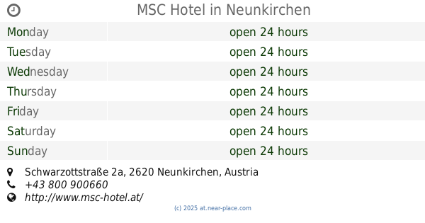
MSC Hotel
Schwarzottstraße 2a, Neunkirchen
Lodging
read more
4.14 km
Woltron
Bogengasse 106, Würflach
Lodging
read more
4.173 km
Leopold Arthold
Bahnstraße 22
Lodging
read more
4.541 km
Christa Pieler
Wienerstraße 26, Neunkirchen
Lodging
read more
4.543 km
Gasthaus zum Brückl
Wienerstraße 26, Neunkirchen
Lodging
read more
4.824 km
Kerzendiele
Fabriksgasse 19, Neunkirchen
Lodging
read more
4.87 km
City Hotel Neunkirchen
Fabriksgasse 24, Neunkirchen
Lodging
read more
5.05 km
Schmankerl Eck
Rüsthausweg 19
Lodging
read more
5.054 km
Gasthaus Waitzbauer
Buchbacherstraße 1
Lodging
read more
5.1 km
Lambrechter Gasthaus
Fabriksstraße 12, Ternitz
Lodging
read more
5.334 km
Betreubares Wohnen
Gemeinde, Sankt Valentin-Landschach
Lodging
read more
9.43 km
Apartment Robert
Nettinger Straße 302/1, Maiersdorf
Lodging
read more
9.831 km
Hochkogelhaus
Hochkogelstraße 127, Hohe Wand
Lodging
read more
9.903 km
Schwarzau
Mariensiedlung 1, Schwarzau am Steinfeld
Lodging
read more
11.995 km
Ludwig Senninger
Marktplatz 1, Warth
Lodging
read more
📑
all categories
Accounting
Administrative area level 1
Administrative area level 2
Airport
Amusement park
Aquarium
Art gallery
Atm
Bakery
Bank
Bar
Beauty salon
Bicycle store
Book store
Bowling alley
Bus station
Cafe
Campground
Car dealer
Car rental
Car repair
Car wash
Casino
Cemetery
Church
City hall
Clothing store
Colloquial area
Convenience store
Country
Courthouse
Dentist
Department store
Doctor
Electrician
Electronics store
Embassy
Finance
Fire station
Florist
Food
Funeral home
Furniture store
Gas station
General contractor
Grocery or supermarket
Gym
Hair care
Hardware store
Health
Hindu Temple
Home goods store
Hospital
Insurance agency
Jewelry store
Laundry
Lawyer
Library
Light rail station
Liquor store
Local government office
Locality
Locksmith
Lodging
Meal delivery
Meal takeaway
Mosque
Movie rental
Movie theater
Moving company
Museum
Natural feature
Neighborhood
Night club
Painter
Park
Parking
Pet store
Pharmacy
Physiotherapist
Place of worship
Plumber
Point of interest
Police
Political
Post office
Premise
Real estate agency
Restaurant
Roofing contractor
Route
Rv park, camping
School
Shoe store
Shopping mall
Spa
Stadium
Storage
Store
Subpremise
Subway station
Supermarket
Synagogue
Taxi stand
Train station
Transit station
Travel agency
University
Veterinary care
Zoo
administrative area level 3
sublocality level 1
↑