Lodging nearby Wolfgang Grabher
Coronavirus disease (COVID-19) Situation
confirmed cases
6081287
deaths
22542
Austria
Lodging nearby Wolfgang Grabher
Wolfgang Grabher
Dorfstraße 52, Fußach Austria
contacts phone
:
+43
Latitude:
47.4752872
, Longitude:
9.6617383
read more
nearest Lodging
1.63 km
Ferienwohnung Jutta
Flurstraße 28a, Höchst
Lodging
read more
1.636 km
Ferienwohnungen Schneider
Flurstraße 28a, Höchst
Lodging
read more
1.795 km
Apartment Maria
Flurstraße 5, Höchst
Lodging
read more
1.977 km
kanapee - Ferienwohnung
Hofgarten 3, Höchst
Lodging
read more
2.09 km
Junges Hotel Hard
Allmendstraße 87, Hard
Lodging
read more
2.227 km
JURO's Appartment
Hauptstraße 27 TOP 9, Höchst
Lodging
read more
2.304 km
Hard Rheinstrasse 33
Rheinstraße, Hard
Lodging
read more
2.31 km
Ferienhaus Höchst
Gartenstrasse 12, Höchst
Lodging
read more
2.328 km
Unterberger
Sonnengarten 32a, Höchst
Lodging
read more
2.328 km
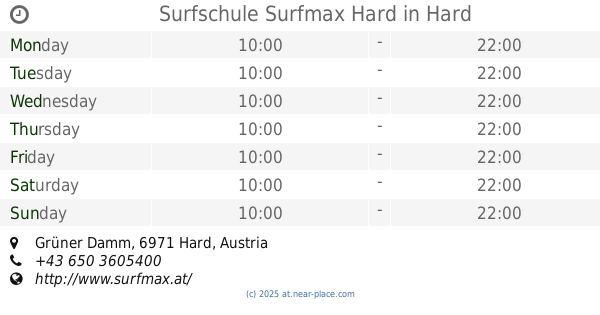
Surfschule Surfmax Hard
Grüner Damm, Hard
Lodging
read more
2.375 km
Hotel Angelika
Landstraße 27, Hard
Lodging
read more
2.375 km
Paul Fritz Renn
Landstraße 27, Hard
Lodging
read more
2.498 km
Hotel am See
Uferstraße 1, Hard
Lodging
read more
2.512 km
Hotel & Landgasthof Linde
Kirchplatz 16, Höchst
Lodging
read more
2.775 km
The smart Hotel Garni - Maximum
Landstraße 57, Höchst
Lodging
read more
2.775 km
Renate Steurer
Landstraße 57, Höchst
Lodging
read more
2.812 km
Ferienwohnung Ingeborg
Am Sägenkanal 2, Hard
Lodging
read more
2.814 km
Die Krone
Hofsteigstraße 14, Hard
Lodging
read more
2.814 km
Gasthaus Krone
Hofsteigstraße 14, Hard
Lodging
read more
2.821 km
Hotel Krone Hard
Hofsteigstraße 14, Hard
Lodging
read more
2.916 km
Seaside Apartment
Kohlplatzstraße 13, Hard
Lodging
read more
2.936 km
Gasthof Hecht
Gaißauer Straße 26, Höchst
Lodging
read more
2.939 km
Gasthaus Hecht
Gaißauer Straße 26, Höchst
Lodging
read more
3.279 km
Gästehaus Gritsch
Rauhholzstraße 7b, Hard
Lodging
read more
3.423 km
Neulandstrasse Endpunkt
Hard
Lodging
read more
📑
all categories
Accounting
Administrative area level 1
Administrative area level 2
Airport
Amusement park
Aquarium
Art gallery
Atm
Bakery
Bank
Bar
Beauty salon
Bicycle store
Book store
Bowling alley
Bus station
Cafe
Campground
Car dealer
Car rental
Car repair
Car wash
Casino
Cemetery
Church
City hall
Clothing store
Colloquial area
Convenience store
Country
Courthouse
Dentist
Department store
Doctor
Electrician
Electronics store
Embassy
Finance
Fire station
Florist
Food
Funeral home
Furniture store
Gas station
General contractor
Grocery or supermarket
Gym
Hair care
Hardware store
Health
Hindu Temple
Home goods store
Hospital
Insurance agency
Jewelry store
Laundry
Lawyer
Library
Light rail station
Liquor store
Local government office
Locality
Locksmith
Lodging
Meal delivery
Meal takeaway
Mosque
Movie rental
Movie theater
Moving company
Museum
Natural feature
Neighborhood
Night club
Painter
Park
Parking
Pet store
Pharmacy
Physiotherapist
Place of worship
Plumber
Point of interest
Police
Political
Post office
Premise
Real estate agency
Restaurant
Roofing contractor
Route
Rv park, camping
School
Shoe store
Shopping mall
Spa
Stadium
Storage
Store
Subpremise
Subway station
Supermarket
Synagogue
Taxi stand
Train station
Transit station
Travel agency
University
Veterinary care
Zoo
administrative area level 3
sublocality level 1
↑