Night club nearby Club Schwarzenberg
Coronavirus disease (COVID-19) Situation
confirmed cases
6081287
deaths
22542
Austria
Night club nearby Club Schwarzenberg
Club Schwarzenberg
Schwarzenbergplatz 7, Wien Austria
contacts phone
:
+43
Latitude:
48.1986194
, Longitude:
16.3772897
read more
nearest Night club
201 m
ost klub
Schwarzenbergplatz 10, Wien
Night club
read more
555 m
Opera Club
Mahlerstraße 11, Wien
Night club
read more
644 m
Bettel-Alm - Das Original
Johannesgasse 12, Wien
Night club
read more
659 m
Staniplatz
Night club
read more
668 m
BEFANA Club Stadl - Partylocation Wien
Johannesgasse 21, Wien
Night club
read more
675 m
Bristol Lounge
Kärntner Ring 1, Wien
Night club
read more
705 m
Tina's Eve
Schellinggasse 1, Wien
Night club
read more
707 m
Lido di Vienna
Schellinggasse 1, Wien
Night club
read more
730 m
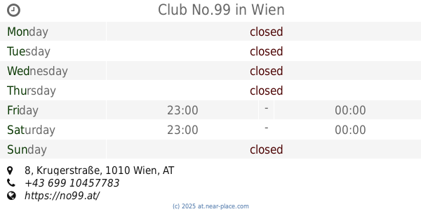
Club No.99
Krugerstraße 8, Wien
Night club
read more
782 m
Beverly Hills Club Vienna
Seilerstätte 5, Wien
Night club
read more
789 m
Chamäleon Club
Favoritenstraße 26 Eingang, Mayerhofgasse, Wien
Night club
read more
813 m
Scotch Club
Parkring 10, Wien
Night club
read more
836 m
Babylon Wien
1, Seilerstätte, Wien
Night club
read more
855 m
Actress Lounge
Liebenberggasse 1, Wien
Night club
read more
898 m
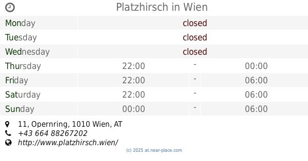
Platzhirsch
Opernring 11, Wien
Night club
read more
914 m
Hudson Diskotheken Betriebsgesellschaft m.b.H.
Hanuschgasse 3, Wien
Night club
read more
914 m
Russian Begleitargentur GmbH Vienna
1010, Opernring 13, Wien
Night club
read more
914 m
Porgy & Bess
Riemergasse 11, Wien
Night club
read more
923 m
Hellseherin Ezra
Rauhensteingasse 10, Wien
Night club
read more
932 m
Box
Landstraßer Hauptstraße 2, Wien
Night club
read more
1.017 km
Kulturforum DanAustria
Keilgasse 12, Wien
Night club
read more
1.046 km
Viper Room
Landstraßer Hauptstraße 38, Wien
Night club
read more
1.092 km
Sing Your Song
Eschenbachgasse 5, Wien
Night club
read more
1.104 km
La Casa De Boi
Graf-Starhemberg-Gasse, Wien
Night club
read more
1.107 km
Club Alice
Josefsplatz 6, Wien
Night club
read more
📑
all categories
Accounting
Administrative area level 1
Administrative area level 2
Airport
Amusement park
Aquarium
Art gallery
Atm
Bakery
Bank
Bar
Beauty salon
Bicycle store
Book store
Bowling alley
Bus station
Cafe
Campground
Car dealer
Car rental
Car repair
Car wash
Casino
Cemetery
Church
City hall
Clothing store
Colloquial area
Convenience store
Country
Courthouse
Dentist
Department store
Doctor
Electrician
Electronics store
Embassy
Finance
Fire station
Florist
Food
Funeral home
Furniture store
Gas station
General contractor
Grocery or supermarket
Gym
Hair care
Hardware store
Health
Hindu Temple
Home goods store
Hospital
Insurance agency
Jewelry store
Laundry
Lawyer
Library
Light rail station
Liquor store
Local government office
Locality
Locksmith
Lodging
Meal delivery
Meal takeaway
Mosque
Movie rental
Movie theater
Moving company
Museum
Natural feature
Neighborhood
Night club
Painter
Park
Parking
Pet store
Pharmacy
Physiotherapist
Place of worship
Plumber
Point of interest
Police
Political
Post office
Premise
Real estate agency
Restaurant
Roofing contractor
Route
Rv park, camping
School
Shoe store
Shopping mall
Spa
Stadium
Storage
Store
Subpremise
Subway station
Supermarket
Synagogue
Taxi stand
Train station
Transit station
Travel agency
University
Veterinary care
Zoo
administrative area level 3
sublocality level 1
↑