Night club nearby Rumba & Mambo
Austria
Night club nearby Rumba & Mambo
Rumba & Mambo
Donauinsel, Wien Österreich
contacts phone
:
+43
Latitude:
48.2304173
, Longitude:
16.408073
read more
nearest Night club
603 m
Kuhle Socke
Wehlistraße 131-143 12, Wien
Night club
read more
1.232 km
Studio BeiGabi
Obermüllnerstraße 17, Wien
Night club
read more
1.234 km
Victory Club
Leopold-Moses-Gasse 4, Wien
Night club
read more
1.293 km
Safari Club
Austria, Obermüllnerstraße 1, Wien
Night club
read more
1.294 km
Safari Bar
Obermüllnerstraße 1, Wien
Night club
read more
1.347 km
http://www.studionelly.at
10/1, Ybbsstraße, Wien
Night club
read more
1.407 km
Xena Bar
Molkereistraße 3, Wien
Night club
read more
1.46 km
Faily's Shisha Lounge
Ausstellungsstraße 23, Wien
Night club
read more
1.485 km
Studio 126
Engerthstraße 126, Wien
Night club
read more
1.714 km
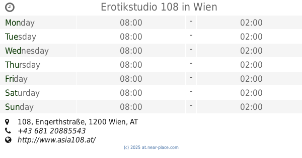
Erotikstudio 108
Engerthstraße 108, Wien
Night club
read more
1.789 km
Fluc und Fluc Wanne
Praterstern 5, Wien
Night club
read more
1.917 km
Pratersauna
Waldsteingartenstraße 135, Wien
Night club
read more
1.92 km
Vie i pee
Csardastraße 135, Wien
Night club
read more
1.92 km
VIEiPEE
Csardastraße 135, Wien
Night club
read more
1.979 km
Ellys Bar
Heinestraße 30, Wien
Night club
read more
2.058 km
A-Danceclub
Handelskai 94-96, Wien
Night club
read more
2.062 km
Executive Lounge
Handelskai 269, Wien
Night club
read more
2.062 km
Hilton Vienna Danube Waterfront Executive Lounge
Vienna
Night club
read more
2.148 km
Madame Bar
Hofenedergasse 4, Wien
Night club
read more
2.162 km
TUBEROSE - STUDIO
Hofenedergasse 1, Wien
Night club
read more
2.257 km
Nachtschicht
Wagramer Straße 79, Wien
Night club
read more
2.261 km
Bollwerkk Wien
Wagramer Straße 79, Wien
Night club
read more
2.282 km
GBV Gastro Betriebs- und Verwaltungs GmbH
Wagramer Straße 79, Wien
Night club
read more
2.312 km
Bollwerk Wien
Wagramer Straße 79, Wien
Night club
read more
2.683 km
Club Alpha
Untere Donaustraße 21, Wien
Night club
read more
📑
all categories
Accounting
Administrative area level 1
Administrative area level 2
Airport
Amusement park
Aquarium
Art gallery
Atm
Bakery
Bank
Bar
Beauty salon
Bicycle store
Book store
Bowling alley
Bus station
Cafe
Campground
Car dealer
Car rental
Car repair
Car wash
Casino
Cemetery
Church
City hall
Clothing store
Colloquial area
Convenience store
Country
Courthouse
Dentist
Department store
Doctor
Electrician
Electronics store
Embassy
Finance
Fire station
Florist
Food
Funeral home
Furniture store
Gas station
General contractor
Grocery or supermarket
Gym
Hair care
Hardware store
Health
Hindu Temple
Home goods store
Hospital
Insurance agency
Jewelry store
Laundry
Lawyer
Library
Light rail station
Liquor store
Local government office
Locality
Locksmith
Lodging
Meal delivery
Meal takeaway
Mosque
Movie rental
Movie theater
Moving company
Museum
Natural feature
Neighborhood
Night club
Painter
Park
Parking
Pet store
Pharmacy
Physiotherapist
Place of worship
Plumber
Point of interest
Police
Political
Post office
Premise
Real estate agency
Restaurant
Roofing contractor
Route
Rv park, camping
School
Shoe store
Shopping mall
Spa
Stadium
Storage
Store
Subpremise
Subway station
Supermarket
Synagogue
Taxi stand
Train station
Transit station
Travel agency
University
Veterinary care
Zoo
administrative area level 3
sublocality level 1
↑