Night club nearby Swingerclub Traumland
Austria
Night club nearby Swingerclub Traumland
Swingerclub Traumland
Schlösselgasse 11, Wien Österreich
contacts phone
:
+43
Latitude:
48.2127779
, Longitude:
16.353148
read more
nearest Night club
394 m
Tanzbar Gerard
Lederergasse 11, Wien
Night club
read more
411 m
Mirakel
Alser Straße 18, Wien
Night club
read more
450 m
Casa di Amore
Alser Straße 37, Wien
Night club
read more
644 m
Yamm!
Universitätsring 10, Wien
Night club
read more
766 m
City Club Vienna
Lerchenfelder Straße 35, Wien
Night club
read more
804 m
ZERO INCH Digitale Medien GmbH
Kolingasse 9, Wien
Night club
read more
830 m
Restaurant Petit Maroc
Neubaugasse 84, Wien
Night club
read more
884 m
Volksgarten
Volksgarten, Wien
Night club
read more
890 m
Säulenhalle
Burgring, Wien
Night club
read more
905 m
Club Duplex
18, Hernalser Gürtel, Wien
Night club
read more
969 m
HROBARAMA LOFT
Tendlergasse 12/416, Wien
Night club
read more
973 m
bestens. Cocktailbar
Burggasse 23, Wien
Night club
read more
973 m
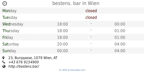
bestens. bar
Burggasse 23, Wien
Night club
read more
982 m
Passion CLC
Hernalser Hauptstraße 5, Wien
Night club
read more
988 m
Josefstadt und Söhne
Josefstädter Straße 103, Wien
Night club
read more
1.03 km
Dual
Burggasse 70, Wien
Night club
read more
1.085 km
Papillon Sauna
Müllnergasse 5, Wien
Night club
read more
1.145 km
Auslage
Lerchenfelder Gürtel 43, Wien
Night club
read more
1.265 km
Passage
Burgring 3, Wien
Night club
read more
1.28 km
Peepshow Wien
112, Burggasse, Wien
Night club
read more
1.28 km
Laufhaus Wien, Peepshow Burggasse
112, Burggasse, Wien
Night club
read more
1.384 km
Cabaret Fledermaus
Spiegelgasse 2, Wien
Night club
read more
1.619 km
Jazzland
Franz-Josefs-Kai 29, Wien
Night club
read more
1.818 km
goodmann
Rechte Wienzeile 23, Wien
Night club
read more
2.328 km
ost klub
Schwarzenbergplatz 10, Wien
Night club
read more
📑
all categories
Accounting
Administrative area level 1
Administrative area level 2
Airport
Amusement park
Aquarium
Art gallery
Atm
Bakery
Bank
Bar
Beauty salon
Bicycle store
Book store
Bowling alley
Bus station
Cafe
Campground
Car dealer
Car rental
Car repair
Car wash
Casino
Cemetery
Church
City hall
Clothing store
Colloquial area
Convenience store
Country
Courthouse
Dentist
Department store
Doctor
Electrician
Electronics store
Embassy
Finance
Fire station
Florist
Food
Funeral home
Furniture store
Gas station
General contractor
Grocery or supermarket
Gym
Hair care
Hardware store
Health
Hindu Temple
Home goods store
Hospital
Insurance agency
Jewelry store
Laundry
Lawyer
Library
Light rail station
Liquor store
Local government office
Locality
Locksmith
Lodging
Meal delivery
Meal takeaway
Mosque
Movie rental
Movie theater
Moving company
Museum
Natural feature
Neighborhood
Night club
Painter
Park
Parking
Pet store
Pharmacy
Physiotherapist
Place of worship
Plumber
Point of interest
Police
Political
Post office
Premise
Real estate agency
Restaurant
Roofing contractor
Route
Rv park, camping
School
Shoe store
Shopping mall
Spa
Stadium
Storage
Store
Subpremise
Subway station
Supermarket
Synagogue
Taxi stand
Train station
Transit station
Travel agency
University
Veterinary care
Zoo
administrative area level 3
sublocality level 1
↑