Night club nearby Swingers Club Paradise
Austria
Night club nearby Swingers Club Paradise
Swingers Club Paradise
Untere Augartenstraße 36, Wien Österreich
contacts phone
:
+43
Latitude:
48.221765
, Longitude:
16.3743082
read more
nearest Night club
238 m
Zebra Caffe
Rembrandtstraße 15, Wien
Night club
read more
367 m
Kolloni's Hittn
Herminengasse 15, Wien
Night club
read more
508 m
Flex
Augartenbrücke 1, Wien
Night club
read more
815 m
Pigalle
Blumauergasse 14, Wien
Night club
read more
880 m
Papillon Sauna
Müllnergasse 5, Wien
Night club
read more
982 m
Prime
Salzgries 4, Wien
Night club
read more
1.011 km
Ellys Bar
Heinestraße 30, Wien
Night club
read more
1.015 km
Viva Club
Nordwestbahnstraße 53, Wien
Night club
read more
1.059 km
ZERO INCH Digitale Medien GmbH
Kolingasse 9, Wien
Night club
read more
1.06 km
BALALAIKA
Fischerstiege 1-7, Wien
Night club
read more
1.075 km
Jazzland
Franz-Josefs-Kai 29, Wien
Night club
read more
1.22 km
Club Alpha
Untere Donaustraße 21, Wien
Night club
read more
1.311 km
VIENNA Technology, Transfer Corporation GmbH
Kramergasse 9, Wien
Night club
read more
1.337 km
Yamm!
Universitätsring 10, Wien
Night club
read more
1.357 km
TUBEROSE - STUDIO
Hofenedergasse 1, Wien
Night club
read more
1.388 km
Madame Bar
Hofenedergasse 4, Wien
Night club
read more
1.572 km
Cabaret Fledermaus
Spiegelgasse 2, Wien
Night club
read more
1.669 km
Porgy & Bess
Riemergasse 11, Wien
Night club
read more
1.75 km
Babylon Wien
1, Seilerstätte, Wien
Night club
read more
1.889 km
FAME
Untergrundbahn Bogen 184, Wien
Night club
read more
1.909 km
Säulenhalle
Burgring, Wien
Night club
read more
1.919 km
Studio 126
Engerthstraße 126, Wien
Night club
read more
2.005 km
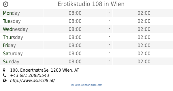
Erotikstudio 108
Engerthstraße 108, Wien
Night club
read more
2.006 km
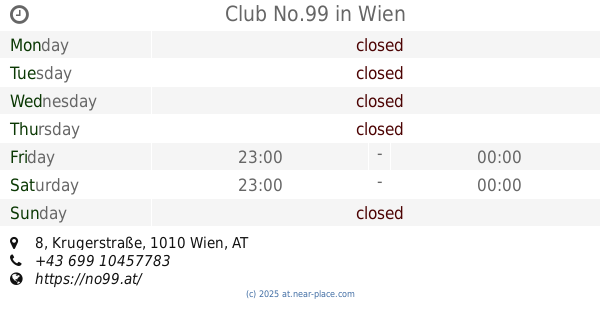
Club No.99
Krugerstraße 8, Wien
Night club
read more
2.253 km
Tanzbar Gerard
Lederergasse 11, Wien
Night club
read more
📑
all categories
Accounting
Administrative area level 1
Administrative area level 2
Airport
Amusement park
Aquarium
Art gallery
Atm
Bakery
Bank
Bar
Beauty salon
Bicycle store
Book store
Bowling alley
Bus station
Cafe
Campground
Car dealer
Car rental
Car repair
Car wash
Casino
Cemetery
Church
City hall
Clothing store
Colloquial area
Convenience store
Country
Courthouse
Dentist
Department store
Doctor
Electrician
Electronics store
Embassy
Finance
Fire station
Florist
Food
Funeral home
Furniture store
Gas station
General contractor
Grocery or supermarket
Gym
Hair care
Hardware store
Health
Hindu Temple
Home goods store
Hospital
Insurance agency
Jewelry store
Laundry
Lawyer
Library
Light rail station
Liquor store
Local government office
Locality
Locksmith
Lodging
Meal delivery
Meal takeaway
Mosque
Movie rental
Movie theater
Moving company
Museum
Natural feature
Neighborhood
Night club
Painter
Park
Parking
Pet store
Pharmacy
Physiotherapist
Place of worship
Plumber
Point of interest
Police
Political
Post office
Premise
Real estate agency
Restaurant
Roofing contractor
Route
Rv park, camping
School
Shoe store
Shopping mall
Spa
Stadium
Storage
Store
Subpremise
Subway station
Supermarket
Synagogue
Taxi stand
Train station
Transit station
Travel agency
University
Veterinary care
Zoo
administrative area level 3
sublocality level 1
↑