Park nearby Freude am Schönen
Coronavirus disease (COVID-19) Situation
confirmed cases
6081287
deaths
22542
Austria
Park nearby Freude am Schönen
Freude am Schönen
Linz Ausztria
contacts phone
:
+43
Latitude:
48.2942936
, Longitude:
14.2922271
read more
nearest Park
124 m
Volksgarten
Linz
Park
read more
127 m
Lausbub, Bronzeplastik
Volksgartenstraße, Linz
Park
read more
236 m
Viva Sativa - Head & Hemp-Fashion Shop
Goethestraße 6a, Linz
Park
read more
236 m
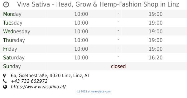
Viva Sativa - Head, Grow & Hemp-Fashion Shop
Goethestraße 6a, Linz
Park
read more
389 m
Schillerpark
Landstraße 89, Linz
Park
read more
429 m
Brunnen Bahnhofsvorplatz
Bahnhofplatz, Linz
Park
read more
644 m
Eingangstor zu Park der oö. Landwirtschaftskammer
Bernardisstraße 1, Linz
Park
read more
649 m
City-Park
Linz
Park
read more
686 m
Bronzebrunnen (ehemalige Hatschekvilla), 1559
Auf der Gugl, Linz
Park
read more
711 m
Hessenplatz Park
Hessenplatz, Linz
Park
read more
725 m
Hessenpark
Hessenplatz 2, Linz
Park
read more
726 m
Gedenktafel dem schöpfer der Bauernberganlage Ludwig Hatschek
Bernardisstraße 1, Linz
Park
read more
763 m
Ziegeleipark
Innenstadt
Park
read more
777 m
Neptunbrunnen am Balzarek-Rondeau
Auf der Gugl, Linz
Park
read more
821 m
Dompark
Baumbachstraße 1, Linz
Park
read more
826 m
Bauernberg Park
Bernardisstraße 1, Linz
Park
read more
827 m
Bauernberg Park
Linz
Park
read more
883 m
Andreas-Hofer-Park
Linz
Park
read more
892 m
Brunnen Klosterhof (1650)
Bischofstraße, Linz
Park
read more
909 m
Brunnen Ursulinenhof
Landstraße, Linz
Park
read more
978 m
Gänselieslbrunnen
Lustenauer Straße, Linz
Park
read more
983 m
Hundertwasserbrunnen
Spittelwiese, Linz
Park
read more
983 m
Brunnen "Hand" "Hundertwasserbrunnen"
Spittelwiese, Linz
Park
read more
1.098 km
GWG Park
Harrachstraße 35, Linz
Park
read more
1.176 km
Jubiläumsbrunnen Gürtelstraße
Gürtelstraße 12a, Linz
Park
read more
📑
all categories
Accounting
Administrative area level 1
Administrative area level 2
Airport
Amusement park
Aquarium
Art gallery
Atm
Bakery
Bank
Bar
Beauty salon
Bicycle store
Book store
Bowling alley
Bus station
Cafe
Campground
Car dealer
Car rental
Car repair
Car wash
Casino
Cemetery
Church
City hall
Clothing store
Colloquial area
Convenience store
Country
Courthouse
Dentist
Department store
Doctor
Electrician
Electronics store
Embassy
Finance
Fire station
Florist
Food
Funeral home
Furniture store
Gas station
General contractor
Grocery or supermarket
Gym
Hair care
Hardware store
Health
Hindu Temple
Home goods store
Hospital
Insurance agency
Jewelry store
Laundry
Lawyer
Library
Light rail station
Liquor store
Local government office
Locality
Locksmith
Lodging
Meal delivery
Meal takeaway
Mosque
Movie rental
Movie theater
Moving company
Museum
Natural feature
Neighborhood
Night club
Painter
Park
Parking
Pet store
Pharmacy
Physiotherapist
Place of worship
Plumber
Point of interest
Police
Political
Post office
Premise
Real estate agency
Restaurant
Roofing contractor
Route
Rv park, camping
School
Shoe store
Shopping mall
Spa
Stadium
Storage
Store
Subpremise
Subway station
Supermarket
Synagogue
Taxi stand
Train station
Transit station
Travel agency
University
Veterinary care
Zoo
administrative area level 3
sublocality level 1
↑