Restaurant nearby Der Brandstetterhof ****
Coronavirus disease (COVID-19) Situation
confirmed cases
6081287
deaths
22542
Austria
Restaurant nearby Der Brandstetterhof ****
Der Brandstetterhof ****
Der Brandstetterhof ****, Oberdorf 74, 6135 Stans, Austria
contacts phone
:
+43 5242 63582
website:
www.brandstetterhof.com
Latitude:
47.3701983
, Longitude:
11.7152755
larger map & directions
read more
nearest Restaurant
95 m
Stans Tirol
Vogelsang 207, Stans
Restaurant
read more
562 m
Pizzeria Da Capo
Tenniscenter 1, Stans
Restaurant
read more
595 m
Tenniscenter Stans
Tenniscenter 1, Stans
Restaurant
read more
1.587 km
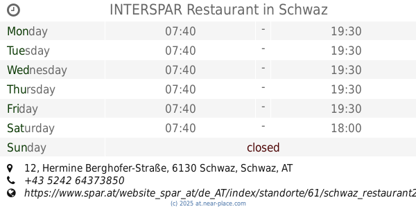
INTERSPAR Restaurant
Hermine Berghofer-Straße 12, Schwaz
Restaurant
read more
1.686 km
Pizzeria Paparazzi
Doktor-Karl-Psenner-Straße 44, Schwaz
Restaurant
read more
1.755 km
Kaminstub´n Barbarastub´n Schwaz
Anton-Öfner-Straße 27, Schwaz
Restaurant
read more
1.755 km
Kaminstubn
Anton-Öfner-Straße 27, Schwaz
Restaurant
read more
1.838 km
Kochschlitten
Anton-Öfner-Straße 8, Schwaz
Restaurant
read more
1.983 km
Enzenbergs Jausenbuffet
Johannes-Messner-Weg 14, Schwaz
Restaurant
read more
2.039 km
Knappenkuchl
Alte Landstraße 3a, Schwaz
Restaurant
read more
2.149 km
Klostergasthaus
Fiecht 5, Fiecht
Restaurant
read more
2.149 km
Klostergasthaus
Fiecht 5, Vomp
Restaurant
read more
2.302 km
Dinos
Münchner Straße 24, Schwaz
Restaurant
read more
2.307 km
Restaurant Swagatam
Falkensteinstraße 28, Schwaz
Restaurant
read more
2.396 km
Schlosswirt Tratzberg
Tratzberg 3, Tratzberg
Restaurant
read more
2.58 km
Marktplatz
Wopfnerstraße 13, Schwaz
Restaurant
read more
2.638 km
Trkish
An der Leiten 15, Vomp
Restaurant
read more
2.675 km
Haikky Vomp
Vomp
Restaurant
read more
2.867 km
Lee Teng Ges.mbH Nfg. KG
Archengasse 1, Schwaz
Restaurant
read more
2.867 km
China-Restaurant Mandarin
Archengasse 1, Schwaz
Restaurant
read more
2.868 km
Zum Mandarin
Archengasse 1, Schwaz
Restaurant
read more
2.908 km
KINGS Lahmacun Kebap and Pizza
Swarovskistraße 15, Schwaz
Restaurant
read more
2.997 km
Dino´s Pizza
Franz-Ullreich-Straße 2, Schwaz
Restaurant
read more
3.117 km
Rosenberger
Schützenweg 1, Vomp
Restaurant
read more
3.128 km
Markt Restaurant Vomp
Schützenweg 1, Vomp
Restaurant
read more
📑
all categories
Accounting
Administrative area level 1
Administrative area level 2
Airport
Amusement park
Aquarium
Art gallery
Atm
Bakery
Bank
Bar
Beauty salon
Bicycle store
Book store
Bowling alley
Bus station
Cafe
Campground
Car dealer
Car rental
Car repair
Car wash
Casino
Cemetery
Church
City hall
Clothing store
Colloquial area
Convenience store
Country
Courthouse
Dentist
Department store
Doctor
Electrician
Electronics store
Embassy
Finance
Fire station
Florist
Food
Funeral home
Furniture store
Gas station
General contractor
Grocery or supermarket
Gym
Hair care
Hardware store
Health
Hindu Temple
Home goods store
Hospital
Insurance agency
Jewelry store
Laundry
Lawyer
Library
Light rail station
Liquor store
Local government office
Locality
Locksmith
Lodging
Meal delivery
Meal takeaway
Mosque
Movie rental
Movie theater
Moving company
Museum
Natural feature
Neighborhood
Night club
Painter
Park
Parking
Pet store
Pharmacy
Physiotherapist
Place of worship
Plumber
Point of interest
Police
Political
Post office
Premise
Real estate agency
Restaurant
Roofing contractor
Route
Rv park, camping
School
Shoe store
Shopping mall
Spa
Stadium
Storage
Store
Subpremise
Subway station
Supermarket
Synagogue
Taxi stand
Train station
Transit station
Travel agency
University
Veterinary care
Zoo
administrative area level 3
sublocality level 1
↑