Restaurant nearby Pizzeria Santa Lucia
Coronavirus disease (COVID-19) Situation
confirmed cases
6081287
deaths
22542
Austria
Restaurant nearby Pizzeria Santa Lucia
Pizzeria Santa Lucia
Salesianergasse 10, Wien Austria
contacts phone
:
+43
Latitude:
48.1987796
, Longitude:
16.3809609
read more
nearest Restaurant
161 m
Asia Bistro
Salesianergasse 3, Wien
Restaurant
read more
176 m
Huber's
Rennweg 11, Wien
Restaurant
read more
305 m
Citybike
Schwarzenbergplatz 5, Wien
Restaurant
read more
456 m
Zhany Asia Cuisine
Prinz Eugen-Straße 2, Wien
Restaurant
read more
464 m
To Ellinikon
Am Heumarkt 5, Wien
Restaurant
read more
474 m
Das Bieramt
Am Heumarkt 3, Wien
Restaurant
read more
507 m
Benkei Restaurant
Ungargasse 65, Wien
Restaurant
read more
691 m
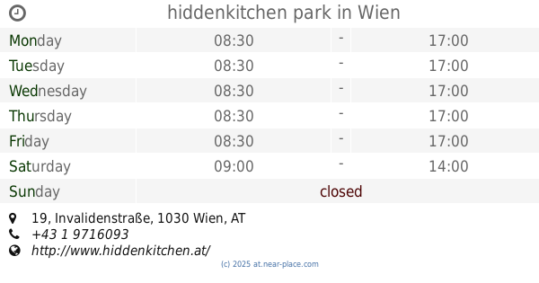
hiddenkitchen park
Invalidenstraße 19, Wien
Restaurant
read more
711 m
Pepito
Hegelgasse 8, Innere Stadt (1.Bez)
Restaurant
read more
754 m
Grappino Chicco GmbH & Co KG
Schwarzenbergstraße 1-3, Wien
Restaurant
read more
761 m
Schesch Besch Restaurant (Middle Eastern Cuisine - Shisha Lounge)
Schwarzenbergstraße 4, Wien
Restaurant
read more
800 m
Kellergwölb Mnozils Restaurant und Gastwirtschaft
Seilerstätte 13, Wien
Restaurant
read more
810 m
Rojda Restaurant
Landstraßer Hauptstraße 38, Wien
Restaurant
read more
837 m
Robert GMBH
Wien, Landstraßer Hauptstraße 46-48 Rochusmarkt Stand 1+2
Restaurant
read more
838 m
Trzesniewski, Filiale Rochusmarkt
Rochusmarkt Stand 8-9, Wien
Restaurant
read more
868 m
Rochus
Landstraßer Hauptstraße 55-57, Wien
Restaurant
read more
892 m
Bistrot Le Petit
Seilerstätte 2, Wien
Restaurant
read more
912 m
Hemmers
Gärtnergasse 12, Wien
Restaurant
read more
915 m
Maido Urban Sushi Bar
Sparefrohgasse 1, Wien
Restaurant
read more
964 m
D´Ischia
Favoritenstraße 8, Wieden (4.Bez)
Restaurant
read more
979 m
Artner
Franziskanerplatz 5, Wien
Restaurant
read more
998 m
McDonald's
U-Bahnpassage, Karlsplatz, Wien
Restaurant
read more
1.028 km
Rosenberger FIRST
Maysedergasse 2, Wien
Restaurant
read more
1.053 km
Gigerl Restaurantbetrieb Gesellschaft m.b.H.
Rauhensteingasse 3, Wien
Restaurant
read more
1.126 km
BiBim
Rennweg 60, Wien
Restaurant
read more
📑
all categories
Accounting
Administrative area level 1
Administrative area level 2
Airport
Amusement park
Aquarium
Art gallery
Atm
Bakery
Bank
Bar
Beauty salon
Bicycle store
Book store
Bowling alley
Bus station
Cafe
Campground
Car dealer
Car rental
Car repair
Car wash
Casino
Cemetery
Church
City hall
Clothing store
Colloquial area
Convenience store
Country
Courthouse
Dentist
Department store
Doctor
Electrician
Electronics store
Embassy
Finance
Fire station
Florist
Food
Funeral home
Furniture store
Gas station
General contractor
Grocery or supermarket
Gym
Hair care
Hardware store
Health
Hindu Temple
Home goods store
Hospital
Insurance agency
Jewelry store
Laundry
Lawyer
Library
Light rail station
Liquor store
Local government office
Locality
Locksmith
Lodging
Meal delivery
Meal takeaway
Mosque
Movie rental
Movie theater
Moving company
Museum
Natural feature
Neighborhood
Night club
Painter
Park
Parking
Pet store
Pharmacy
Physiotherapist
Place of worship
Plumber
Point of interest
Police
Political
Post office
Premise
Real estate agency
Restaurant
Roofing contractor
Route
Rv park, camping
School
Shoe store
Shopping mall
Spa
Stadium
Storage
Store
Subpremise
Subway station
Supermarket
Synagogue
Taxi stand
Train station
Transit station
Travel agency
University
Veterinary care
Zoo
administrative area level 3
sublocality level 1
↑