Restaurant nearby Yoi Restaurant
Coronavirus disease (COVID-19) Situation
confirmed cases
6081287
deaths
22542
Austria
Restaurant nearby Yoi Restaurant
Yoi Restaurant
Klosterneuburger Straße 32, Wien Österreich
contacts phone
:
+43
Latitude:
48.2298108
, Longitude:
16.3677788
read more
nearest Restaurant
117 m
Bistro Europa
Klosterneuburger Straße 19, Wien
Restaurant
read more
226 m
Pizzeria Marcellino
Jägerstraße 29, Wien
Restaurant
read more
235 m
مطعم السفير
Jägerstraße 35, Wien
Restaurant
read more
348 m
Franz Schuster KG
Jägerstraße 10, Wien
Restaurant
read more
462 m
Veggiezz
Alserbachstraße 30, Wien
Restaurant
read more
519 m
حلويات
Alserbachstraße 35, Wien
Restaurant
read more
521 m
Ecker G & A Teltscher Headroom OEG
Obere Donaustraße 3, Wien
Restaurant
read more
529 m
Gasthaus Orlik
Spittelauer Platz 1, Wien
Restaurant
read more
537 m
Capricorn
Clusiusgasse 8, Wien
Restaurant
read more
680 m
Restaurant o christos
Althanstraße 15, Wien
Restaurant
read more
701 m
MAST Weinbistro
Porzellangasse 53, Wien
Restaurant
read more
726 m
Cafe Restaurant "Zum Hannes"
Seegasse 23, Wien
Restaurant
read more
734 m
Bajric Gastro KG
Althanstraße 47, Wien
Restaurant
read more
737 m
Gabel&Co.
Julius-Tandler-Platz 1, Wien
Restaurant
read more
773 m
Thai Lotus Restaurant
Rauscherstraße 15, Wien
Restaurant
read more
800 m
Fantastic Wok
Porzellangasse 50, Wien
Restaurant
read more
822 m
s'Wirtshaus Prein
Rögergasse 4, Wien
Restaurant
read more
868 m
Abend
Alserbachstraße 21, Wien
Restaurant
read more
886 m
Pramerl and the Wolf
Pramergasse 21, Wien
Restaurant
read more
994 m
summerstage
Roßauer Lände 17, Wien
Restaurant
read more
1.011 km
...bin Im Leo
Grünentorgasse 21, Wien
Restaurant
read more
1.02 km
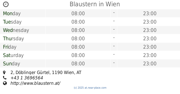
Blaustern
Döblinger Gürtel 2, Wien
Restaurant
read more
1.089 km
Goldener Drachen
Porzellangasse 33, Wien
Restaurant
read more
1.118 km
Gasthaus Wickerl
Porzellangasse 24A, Wien
Restaurant
read more
1.215 km
Fresh Soup & Salad
Dresdner Straße 38-42 / Shop 5 Brigitta-Passage
Restaurant
read more
📑
all categories
Accounting
Administrative area level 1
Administrative area level 2
Airport
Amusement park
Aquarium
Art gallery
Atm
Bakery
Bank
Bar
Beauty salon
Bicycle store
Book store
Bowling alley
Bus station
Cafe
Campground
Car dealer
Car rental
Car repair
Car wash
Casino
Cemetery
Church
City hall
Clothing store
Colloquial area
Convenience store
Country
Courthouse
Dentist
Department store
Doctor
Electrician
Electronics store
Embassy
Finance
Fire station
Florist
Food
Funeral home
Furniture store
Gas station
General contractor
Grocery or supermarket
Gym
Hair care
Hardware store
Health
Hindu Temple
Home goods store
Hospital
Insurance agency
Jewelry store
Laundry
Lawyer
Library
Light rail station
Liquor store
Local government office
Locality
Locksmith
Lodging
Meal delivery
Meal takeaway
Mosque
Movie rental
Movie theater
Moving company
Museum
Natural feature
Neighborhood
Night club
Painter
Park
Parking
Pet store
Pharmacy
Physiotherapist
Place of worship
Plumber
Point of interest
Police
Political
Post office
Premise
Real estate agency
Restaurant
Roofing contractor
Route
Rv park, camping
School
Shoe store
Shopping mall
Spa
Stadium
Storage
Store
Subpremise
Subway station
Supermarket
Synagogue
Taxi stand
Train station
Transit station
Travel agency
University
Veterinary care
Zoo
administrative area level 3
sublocality level 1
↑