Store nearby Blumenwerk
Coronavirus disease (COVID-19) Situation
confirmed cases
6081287
deaths
22542
Austria
Store nearby Blumenwerk
Blumenwerk
6, Marc-Aurel-Straße, 1010, Wien, AT Österreich
contacts phone
:
+43 1 5356990
website:
www.blumenwerk.at
Latitude:
48.2119705
, Longitude:
16.3730638
larger map & directions
read more
nearest Store
240 m
Hans Trimmel
Wildpretmarkt 1, Wien
Store
read more
269 m
The Body Shop
Rotenturmstraße 5-9, Wien
Store
read more
346 m
Ihre Brille Augenoptik
Wollzeile 4, Wien
Store
read more
357 m
Tabak Trafik / Inh. Christian Dolenz
Lilienbrunngasse 3, Wien
Store
read more
361 m
ROMA Hairdressing - Schwedenplatz
Franz-Josefs-Kai 15, Wien
Store
read more
367 m
Bergsport Schwanda
Bäckerstraße 7, Wien
Store
read more
402 m
LIBRO Handelsgesellschaft mbH
Wollzeile 13, Wien
Store
read more
436 m
Mojan Gonzi
Stephansplatz 3, Wien
Store
read more
457 m
SONNENTOR Wien-Wollzeile
Wollzeile 14, Wien
Store
read more
479 m
strictly HERRMANN
Taborstraße 5, Wien
Store
read more
545 m
Numismatik Szaivert
Riemergasse 1, Wien
Store
read more
572 m
Pavlovsky Spezialkunststopferei - Inh. Sylvia Dostal
Predigergasse 3, Wien
Store
read more
582 m
Der Optiker by Wolf2see e. U.
Taborstraße 10, Wien
Store
read more
629 m
Produktionswerkstatt Thomas Kuhn
20/8, Hollandstraße, Wien
Store
read more
642 m
RIMOWA Store Wien
Neuer Markt 2, Wien
Store
read more
659 m
Christian Schubert
Karmelitergasse 1, Wien
Store
read more
766 m
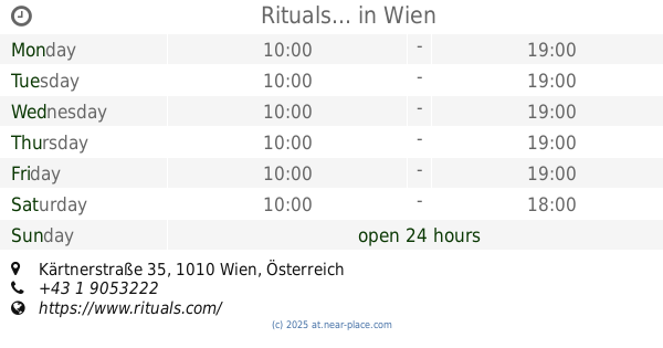
Rituals...
Wien, Kärtnerstraße 35
Store
read more
814 m
Rebenwurzel & Co Ges.mbH
Große Mohrengasse 19, Wien
Store
read more
927 m
Sacher Confiserie Vienna
Philharmoniker Straße 4, Wien
Store
read more
949 m
Park KEG
Parkring 20, Wien
Store
read more
974 m
SlimHeli
Praterstraße 37, Wien
Store
read more
976 m
Gelati Alberti (Gelateria - Cafe - Bar)
40, Praterstraße, Wien
Store
read more
984 m
gudshapes
Glockengasse 13, Wien
Store
read more
1.034 km
Lotteraner GmbH
Glockengasse 19, Wien
Store
read more
1.187 km
Media4Equity Invest
Liechtensteinstraße 25, Wien
Store
read more
📑
all categories
Accounting
Administrative area level 1
Administrative area level 2
Airport
Amusement park
Aquarium
Art gallery
Atm
Bakery
Bank
Bar
Beauty salon
Bicycle store
Book store
Bowling alley
Bus station
Cafe
Campground
Car dealer
Car rental
Car repair
Car wash
Casino
Cemetery
Church
City hall
Clothing store
Colloquial area
Convenience store
Country
Courthouse
Dentist
Department store
Doctor
Electrician
Electronics store
Embassy
Finance
Fire station
Florist
Food
Funeral home
Furniture store
Gas station
General contractor
Grocery or supermarket
Gym
Hair care
Hardware store
Health
Hindu Temple
Home goods store
Hospital
Insurance agency
Jewelry store
Laundry
Lawyer
Library
Light rail station
Liquor store
Local government office
Locality
Locksmith
Lodging
Meal delivery
Meal takeaway
Mosque
Movie rental
Movie theater
Moving company
Museum
Natural feature
Neighborhood
Night club
Painter
Park
Parking
Pet store
Pharmacy
Physiotherapist
Place of worship
Plumber
Point of interest
Police
Political
Post office
Premise
Real estate agency
Restaurant
Roofing contractor
Route
Rv park, camping
School
Shoe store
Shopping mall
Spa
Stadium
Storage
Store
Subpremise
Subway station
Supermarket
Synagogue
Taxi stand
Train station
Transit station
Travel agency
University
Veterinary care
Zoo
administrative area level 3
sublocality level 1
↑