Supermarket nearby EUROSPAR
Coronavirus disease (COVID-19) Situation
confirmed cases
6081287
deaths
22542
Austria
Supermarket nearby EUROSPAR
EUROSPAR
Rheinstraße 72, Bregenz Österreich
contacts phone
:
+43
Latitude:
47.4956308
, Longitude:
9.7141788
read more
nearest Supermarket
479 m
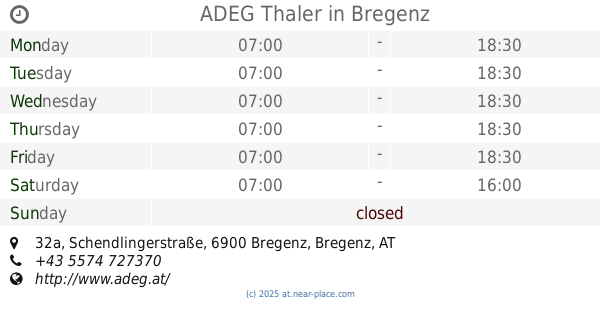
ADEG Thaler
Schendlingerstraße 32a, Bregenz
Supermarket
read more
642 m
SPAR Supermarkt Albi GmbH
Achsiedlungsstraße 51, Bregenz
Supermarket
read more
849 m
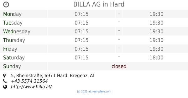
BILLA AG
Rheinstraße 5, Hard
Supermarket
read more
1.093 km
SPAR
Schäfferhofstraße 1, Hard
Supermarket
read more
1.148 km
HOFER
Heldendankstraße 29, Bregenz
Supermarket
read more
1.148 km
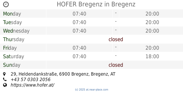
HOFER Bregenz
Heldendankstraße 29, Bregenz
Supermarket
read more
1.148 km
INTERSPAR
Heldendankstraße 22, Bregenz
Supermarket
read more
1.231 km
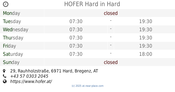
HOFER Hard
Rauhholzstraße 29, Hard
Supermarket
read more
1.231 km
HOFER
Rauhholzstraße 29, Hard
Supermarket
read more
1.397 km
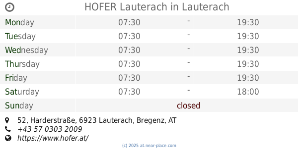
HOFER Lauterach
Harderstraße 52, Lauterach
Supermarket
read more
1.397 km
HOFER
Harderstraße 52, Lauterach
Supermarket
read more
1.443 km
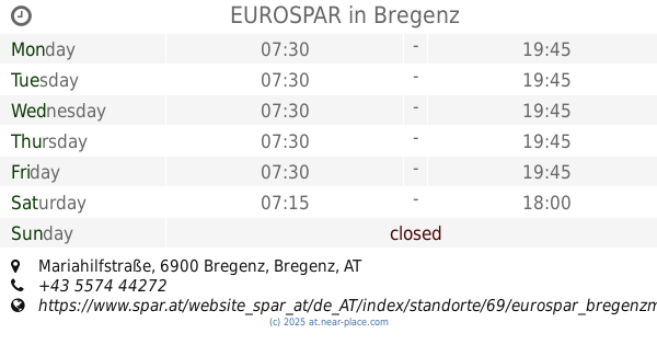
EUROSPAR
2, Mariahilfstraße, Bregenz
Supermarket
read more
1.471 km
ADEG Österreich Handels AG - Zentrale West
Reitschulstraße 5, Lauterach
Supermarket
read more
1.485 km
Yaren Supermarket
Pulverturmgasse 4, Bregenz
Supermarket
read more
1.721 km
SPAR
Hofsteigstraße 15, Hard
Supermarket
read more
1.746 km
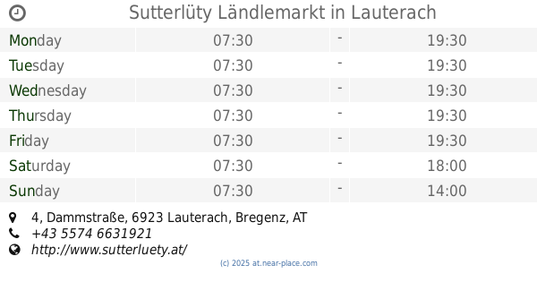
Sutterlüty Ländlemarkt
Dammstraße 4, Lauterach
Supermarket
read more
1.838 km
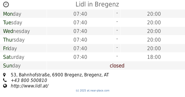
Lidl
Bahnhofstraße 53, Bregenz
Supermarket
read more
1.876 km
SPAR Rita Pircher GmbH
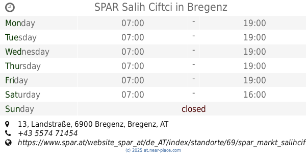
Landstraße 13, Bregenz
Supermarket
read more
1.876 km
SPAR
Landstraße 13, Bregenz
Supermarket
read more
1.882 km
SPAR
Hofsteigstraße 2, Hard
Supermarket
read more
1.882 km
SPAR Zirovnik Daniel e.U. EH-SM
Hofsteigstraße 2, Hard
Supermarket
read more
1.884 km
SPAR Salih Ciftci
Landstraße 13, Bregenz
Supermarket
read more
2.272 km
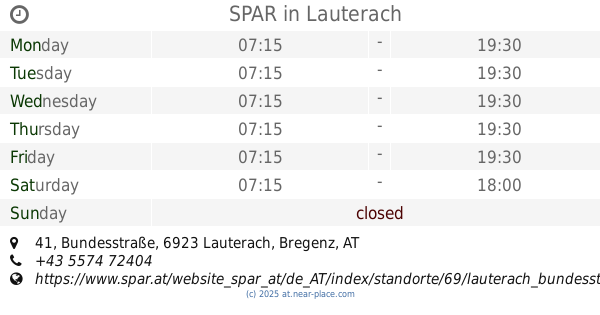
SPAR
Bundesstraße 41, Lauterach
Supermarket
read more
2.49 km
Lidl Österreich GmbH
Bahnhofstraße 17, Hard
Supermarket
read more
2.49 km
Lidl
Bahnhofstraße 17, Hard
Supermarket
read more
📑
all categories
Accounting
Administrative area level 1
Administrative area level 2
Airport
Amusement park
Aquarium
Art gallery
Atm
Bakery
Bank
Bar
Beauty salon
Bicycle store
Book store
Bowling alley
Bus station
Cafe
Campground
Car dealer
Car rental
Car repair
Car wash
Casino
Cemetery
Church
City hall
Clothing store
Colloquial area
Convenience store
Country
Courthouse
Dentist
Department store
Doctor
Electrician
Electronics store
Embassy
Finance
Fire station
Florist
Food
Funeral home
Furniture store
Gas station
General contractor
Grocery or supermarket
Gym
Hair care
Hardware store
Health
Hindu Temple
Home goods store
Hospital
Insurance agency
Jewelry store
Laundry
Lawyer
Library
Light rail station
Liquor store
Local government office
Locality
Locksmith
Lodging
Meal delivery
Meal takeaway
Mosque
Movie rental
Movie theater
Moving company
Museum
Natural feature
Neighborhood
Night club
Painter
Park
Parking
Pet store
Pharmacy
Physiotherapist
Place of worship
Plumber
Point of interest
Police
Political
Post office
Premise
Real estate agency
Restaurant
Roofing contractor
Route
Rv park, camping
School
Shoe store
Shopping mall
Spa
Stadium
Storage
Store
Subpremise
Subway station
Supermarket
Synagogue
Taxi stand
Train station
Transit station
Travel agency
University
Veterinary care
Zoo
administrative area level 3
sublocality level 1
↑