Supermarket nearby SPAR Norbert Pürmayr
Austria
Supermarket nearby SPAR Norbert Pürmayr
SPAR Norbert Pürmayr
Kirchenplatz 14, Kleinraming Österreich
contacts phone
:
+43
Latitude:
48.0097356
, Longitude:
14.4907661
read more
nearest Supermarket
SPAR
Kirchenplatz 14, Kleinraming
Supermarket
read more
5.292 km
BILLA AG
Hubergutstraße 14, Steyr
Supermarket
read more
5.331 km
PENNY Markt
Seitenstettner Straße 1a, Steyr
Supermarket
read more
5.628 km
SPAR
Schillerstraße 12a, Steyr
Supermarket
read more
5.894 km
Hofer Steyr
Pachergasse 19, Steyr
Supermarket
read more
5.894 km
HOFER
Pachergasse 19, Steyr
Supermarket
read more
5.919 km
BILLA
Josef-Rohrauer-Straße 15, Steyr
Supermarket
read more
5.919 km
BILLA AG
Josef-Rohrauer-Straße 15, Steyr
Supermarket
read more
5.935 km
Merkur Markt
Pachergasse 6, Steyr
Supermarket
read more
6.023 km
SPAR
Hans-Wagner-Straße 2-4, Steyr
Supermarket
read more
6.245 km
HOFER
Haager Straße 58, Steyr
Supermarket
read more
6.259 km
BILLA AG
Stadtplatz 30, Steyr
Supermarket
read more
6.391 km
BILLA AG
Leopold-Werndl-Straße 29, Steyr
Supermarket
read more
6.44 km
SPAR
Leopold-Werndl-Straße 2, Steyr
Supermarket
read more
7.246 km
Lidl
Ennser Straße 12, Steyr
Supermarket
read more
7.393 km
Unimarkt
Aschacher Straße 25, Steyr
Supermarket
read more
7.494 km
PENNY Markt
Ennser Straße 31b, Steyr
Supermarket
read more
7.655 km
SPAR
Werner-von-Siemens-Straße 1, Steyr
Supermarket
read more
8.199 km
BILLA Stop&Shop
Ennser Straße 35, Steyr
Supermarket
read more
8.27 km
BILLA AG
Gleinker Hauptstraße 1d, Steyr
Supermarket
read more
8.42 km
Hofer Steyr
Sierninger Straße 131, Steyr
Supermarket
read more
9.204 km
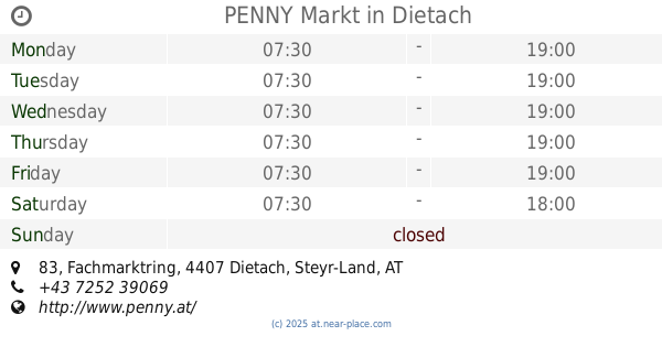
PENNY Markt
Fachmarktring 83, Dietach
Supermarket
read more
9.293 km
ADEG Huber
Dorf an der Enns 240, Haidershofen
Supermarket
read more
12.396 km
BILLA AG
Steyrtalstraße 24, Sierning
Supermarket
read more
12.575 km
HOFER Öttl
Plaik 14, Plaik
Supermarket
read more
📑
all categories
Accounting
Administrative area level 1
Administrative area level 2
Airport
Amusement park
Aquarium
Art gallery
Atm
Bakery
Bank
Bar
Beauty salon
Bicycle store
Book store
Bowling alley
Bus station
Cafe
Campground
Car dealer
Car rental
Car repair
Car wash
Casino
Cemetery
Church
City hall
Clothing store
Colloquial area
Convenience store
Country
Courthouse
Dentist
Department store
Doctor
Electrician
Electronics store
Embassy
Finance
Fire station
Florist
Food
Funeral home
Furniture store
Gas station
General contractor
Grocery or supermarket
Gym
Hair care
Hardware store
Health
Hindu Temple
Home goods store
Hospital
Insurance agency
Jewelry store
Laundry
Lawyer
Library
Light rail station
Liquor store
Local government office
Locality
Locksmith
Lodging
Meal delivery
Meal takeaway
Mosque
Movie rental
Movie theater
Moving company
Museum
Natural feature
Neighborhood
Night club
Painter
Park
Parking
Pet store
Pharmacy
Physiotherapist
Place of worship
Plumber
Point of interest
Police
Political
Post office
Premise
Real estate agency
Restaurant
Roofing contractor
Route
Rv park, camping
School
Shoe store
Shopping mall
Spa
Stadium
Storage
Store
Subpremise
Subway station
Supermarket
Synagogue
Taxi stand
Train station
Transit station
Travel agency
University
Veterinary care
Zoo
administrative area level 3
sublocality level 1
↑