Bakery nearby Baguette Bistro Betriebs-GmbH
Austria
Bakery nearby Baguette Bistro Betriebs-GmbH
Baguette Bistro Betriebs-GmbH
Bachlechnerstraße 46, Innsbruck Austria
contacts phone
:
+43
Latitude:
47.2644708
, Longitude:
11.375507
read more
nearest Bakery
26 m
MPREIS Warenvertriebs GesmbH
Bachlechnerstraße 46, Innsbruck
Bakery
read more
58 m
Baguette
Bachlechnerstraße 46, Innsbruck
Bakery
read more
112 m
Reither Brot
Innsbruck
Bakery
read more
376 m
Stefan Lener
Fischnalerstraße 10, Innsbruck
Bakery
read more
519 m
Baguette
Schneeburggasse 54a, Innsbruck
Bakery
read more
521 m
MPREIS Warenvertriebs GesmbH
Mitterweg 16, Innsbruck
Bakery
read more
521 m
Baguette
Mitterweg 16, Innsbruck
Bakery
read more
523 m
Baguette Bistro Betriebs-GmbH
Mitterweg 16, Innsbruck
Bakery
read more
549 m
Baguette Mitterweg/Würth
Trenkwalderstraße 1, Innsbruck
Bakery
read more
669 m
Baguette
Innrain 70, Innsbruck
Bakery
read more
741 m
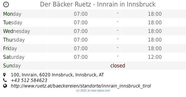
Der Bäcker Ruetz - Innrain
Innrain 100, Innsbruck
Bakery
read more
741 m
Baguette
Innrain 100, Innsbruck
Bakery
read more
828 m
Ruetz & Fagschlunger oHG
Anichstraße 35, Innsbruck
Bakery
read more
829 m
MPREIS Warenvertriebs GesmbH
Innrain 46, Innsbruck
Bakery
read more
834 m
Baguette
Innrain 46, Innsbruck
Bakery
read more
876 m
Der Bäcker Ruetz - Unikreuzung
Anichstraße 46, Innsbruck
Bakery
read more
879 m
Baguette Bistro Betriebs-GmbH
Fischerhäuslweg 31, Innsbruck
Bakery
read more
883 m
MPREIS Warenvertriebs GesmbH
Maximilianstraße 12, Innsbruck
Bakery
read more
888 m
Baguette
Maximilianstraße 12, Innsbruck
Bakery
read more
942 m
Der Bäcker Ruetz - Klinik Innsbruck
Schöpfstraße 26, Innsbruck
Bakery
read more
971 m
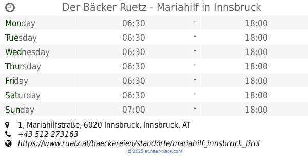
Der Bäcker Ruetz - Mariahilf
Mariahilfstraße 1, Innsbruck
Bakery
read more
987 m
Baguette
Mitterweg 75, Innsbruck
Bakery
read more
1.012 km
Wilhelm Mühlbacher
Herzog-Siegmund-Ufer 1, Innsbruck
Bakery
read more
1.102 km
Baguette
Schneeburggasse 2a, Innsbruck
Bakery
read more
1.17 km
Wilhelm Mühlbacher
Peter-Mayr-Straße 22, Innsbruck
Bakery
read more
📑
all categories
Accounting
Administrative area level 1
Administrative area level 2
Airport
Amusement park
Aquarium
Art gallery
Atm
Bakery
Bank
Bar
Beauty salon
Bicycle store
Book store
Bowling alley
Bus station
Cafe
Campground
Car dealer
Car rental
Car repair
Car wash
Casino
Cemetery
Church
City hall
Clothing store
Colloquial area
Convenience store
Country
Courthouse
Dentist
Department store
Doctor
Electrician
Electronics store
Embassy
Finance
Fire station
Florist
Food
Funeral home
Furniture store
Gas station
General contractor
Grocery or supermarket
Gym
Hair care
Hardware store
Health
Hindu Temple
Home goods store
Hospital
Insurance agency
Jewelry store
Laundry
Lawyer
Library
Light rail station
Liquor store
Local government office
Locality
Locksmith
Lodging
Meal delivery
Meal takeaway
Mosque
Movie rental
Movie theater
Moving company
Museum
Natural feature
Neighborhood
Night club
Painter
Park
Parking
Pet store
Pharmacy
Physiotherapist
Place of worship
Plumber
Point of interest
Police
Political
Post office
Premise
Real estate agency
Restaurant
Roofing contractor
Route
Rv park, camping
School
Shoe store
Shopping mall
Spa
Stadium
Storage
Store
Subpremise
Subway station
Supermarket
Synagogue
Taxi stand
Train station
Transit station
Travel agency
University
Veterinary care
Zoo
administrative area level 3
sublocality level 1
↑