Bakery nearby Huber Bäcker
Austria
Bakery nearby Huber Bäcker
Huber Bäcker
Stadtplatz 11, Leonding Austria
contacts phone
:
+43
Latitude:
48.2789411
, Longitude:
14.2493835
read more
nearest Bakery
147 m
S'Backstüberl
Stadtplatz 5, Leonding
Bakery
read more
201 m
Bäckerei Huber
Michaelsbergstraße 2, Leonding
Bakery
read more
409 m
Fischer Brot GmbH
Zehetlandweg 2, Leonding
Bakery
read more
1.727 km
Haubis Backstube & Cafe Linz - Welserstraße
Welser Straße 39, Leonding
Bakery
read more
1.727 km
HAUBIS bakery & Cafe Linz - Welserstraße
Welser Straße 39, Leonding
Bakery
read more
1.832 km
Bäckerei-Café Resch&Frisch Liebesbrot Leonding
Ehrenfellner-Straße 4
Bakery
read more
2.218 km
Berger Brot
Am Südgarten 71, Leonding
Bakery
read more
2.246 km
Bäckerei Fröstl
Unionstraße 108, Linz
Bakery
read more
2.908 km
Adnan Uyar Gesellschaft m.b.H.
Kapuzinerstraße 84e, Linz
Bakery
read more
3.024 km
Fischer Brot GesmbH
Bauernberg 8, Linz
Bakery
read more
3.024 km
La Baguette
Ramsauerstraße 70, Linz
Bakery
read more
3.429 km
Honeder Naturbackstube
Stockhofstraße 6, Linz
Bakery
read more
3.514 km
Bäckerei Holzpoldl Brot
Hafnerstraße 14, Linz
Bakery
read more
3.558 km
Bäckerei Fenzl
Herrenstraße 64, Linz
Bakery
read more
3.589 km
Bäckerei Fenzl
Hafnerstraße 2, Linz
Bakery
read more
3.692 km
Bäckerei Filipp / Mühlviertler Landbäckerei
Golfplatzstraße 1c, Puchenau
Bakery
read more
3.776 km
Honeder Naturbackstube
Spittelwiese 15, Linz
Bakery
read more
3.79 km
brotsüchtig
Herrenstraße 8, Linz
Bakery
read more
3.794 km
Haubis
Wiener Straße 35, Linz
Bakery
read more
3.796 km
Bäckerei-Café Resch&Frisch Landstraße
Landstraße 70, Linz
Bakery
read more
3.852 km
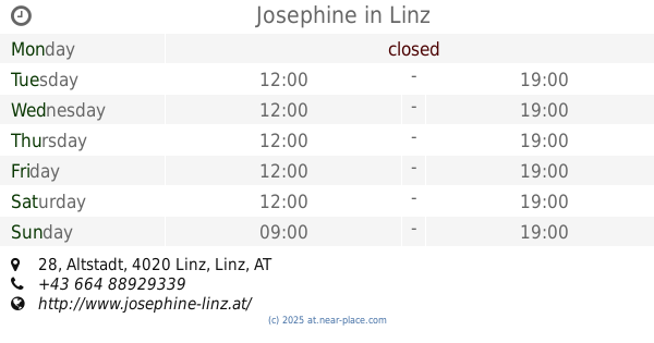
Josephine
Altstadt 28, Linz
Bakery
read more
3.97 km
Wenkler bäckerei & cafe
Landstraße 4020, Linz
Bakery
read more
3.975 km
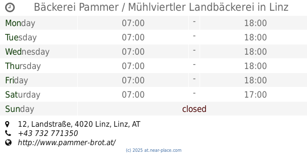
Bäckerei Pammer / Mühlviertler Landbäckerei
Landstraße 12, Linz
Bakery
read more
3.984 km
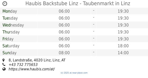
Haubis Backstube Linz - Taubenmarkt
Landstraße 8, Linz
Bakery
read more
4.152 km
k.u.k. Hofbäckerei Café
Pfarrgasse 17, Linz
Bakery
read more
📑
all categories
Accounting
Administrative area level 1
Administrative area level 2
Airport
Amusement park
Aquarium
Art gallery
Atm
Bakery
Bank
Bar
Beauty salon
Bicycle store
Book store
Bowling alley
Bus station
Cafe
Campground
Car dealer
Car rental
Car repair
Car wash
Casino
Cemetery
Church
City hall
Clothing store
Colloquial area
Convenience store
Country
Courthouse
Dentist
Department store
Doctor
Electrician
Electronics store
Embassy
Finance
Fire station
Florist
Food
Funeral home
Furniture store
Gas station
General contractor
Grocery or supermarket
Gym
Hair care
Hardware store
Health
Hindu Temple
Home goods store
Hospital
Insurance agency
Jewelry store
Laundry
Lawyer
Library
Light rail station
Liquor store
Local government office
Locality
Locksmith
Lodging
Meal delivery
Meal takeaway
Mosque
Movie rental
Movie theater
Moving company
Museum
Natural feature
Neighborhood
Night club
Painter
Park
Parking
Pet store
Pharmacy
Physiotherapist
Place of worship
Plumber
Point of interest
Police
Political
Post office
Premise
Real estate agency
Restaurant
Roofing contractor
Route
Rv park, camping
School
Shoe store
Shopping mall
Spa
Stadium
Storage
Store
Subpremise
Subway station
Supermarket
Synagogue
Taxi stand
Train station
Transit station
Travel agency
University
Veterinary care
Zoo
administrative area level 3
sublocality level 1
↑