Bakery nearby Shefa markt & Restaurant
Austria
Bakery nearby Shefa markt & Restaurant
Shefa markt & Restaurant
24, Heinestraße, Wien Ausztria
contacts phone
:
+43
Latitude:
48.2199667
, Longitude:
16.3862683
read more
nearest Bakery
374 m
Pizza Prego
Taborstraße 43/ 5-6, Wien
Bakery
read more
411 m
AIDA
Praterstraße 78, Wien
Bakery
read more
434 m
Geier. Die Bäckerei
Bahnhof Wien Nord - Praterstern, Wien
Bakery
read more
448 m
Geier. Die Bäckerei
Taborstraße 33, Wien
Bakery
read more
459 m
Der Mann der verwöhnt
Praterstraße 52, Wien
Bakery
read more
487 m
Omas Backstube
Obere Augartenstraße 70, Wien
Bakery
read more
489 m
Franz Felber & Co. GmbH
Nordbahnhof, Praterstern, Wien
Bakery
read more
559 m
Der Mann der verwöhnt
Taborstraße 22, Wien
Bakery
read more
629 m
Marina Plistiev
Große Sperlgasse 18, Wien
Bakery
read more
721 m
Rupert Labschütz
Karmelitermarkt 10, Wien
Bakery
read more
731 m
Ayten Bilir KEG
Alliiertenstraße 9, Wien
Bakery
read more
734 m
Meister Backstube
Krummbaumgasse 5, Wien
Bakery
read more
738 m
Ankerbrot AG
Lassallestraße 5, Wien
Bakery
read more
738 m
"Anker Snack & Coffee" Gastronomiebetriebs GmbH
Lassallestraße 5, Wien
Bakery
read more
774 m
Ohel Handelsgesellschaft m.b.H.
Lilienbrunngasse 18, Wien
Bakery
read more
815 m
Shneor´s
Herminengasse 21, Wien
Bakery
read more
870 m
Ohel Handelsges.mbH
Hollandstraße 7, Wien
Bakery
read more
888 m
Bäckerei Grimm
Untere Augartenstraße 39, Wien
Bakery
read more
900 m
Altinyayla HandelsgesmbH
Taborstraße 95, Wien
Bakery
read more
947 m
Bäckerei Grimm
Hollandstraße 1, Wien
Bakery
read more
1.038 km
Ullmann's Zuckerbäckerei
Walcherstraße 11, Wien
Bakery
read more
1.137 km
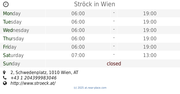
Ströck
Schwedenplatz 2, Wien
Bakery
read more
1.146 km
Ankerbrot AG
Schwedenplatz 2, Wien
Bakery
read more
1.227 km
Der Mann der verwöhnt
Rotenturmstraße 22, Wien
Bakery
read more
1.343 km
Vollkorn-Bio-Bäckerei Waldherr
Marc-Aurel-Straße 4, Wien
Bakery
read more
📑
all categories
Accounting
Administrative area level 1
Administrative area level 2
Airport
Amusement park
Aquarium
Art gallery
Atm
Bakery
Bank
Bar
Beauty salon
Bicycle store
Book store
Bowling alley
Bus station
Cafe
Campground
Car dealer
Car rental
Car repair
Car wash
Casino
Cemetery
Church
City hall
Clothing store
Colloquial area
Convenience store
Country
Courthouse
Dentist
Department store
Doctor
Electrician
Electronics store
Embassy
Finance
Fire station
Florist
Food
Funeral home
Furniture store
Gas station
General contractor
Grocery or supermarket
Gym
Hair care
Hardware store
Health
Hindu Temple
Home goods store
Hospital
Insurance agency
Jewelry store
Laundry
Lawyer
Library
Light rail station
Liquor store
Local government office
Locality
Locksmith
Lodging
Meal delivery
Meal takeaway
Mosque
Movie rental
Movie theater
Moving company
Museum
Natural feature
Neighborhood
Night club
Painter
Park
Parking
Pet store
Pharmacy
Physiotherapist
Place of worship
Plumber
Point of interest
Police
Political
Post office
Premise
Real estate agency
Restaurant
Roofing contractor
Route
Rv park, camping
School
Shoe store
Shopping mall
Spa
Stadium
Storage
Store
Subpremise
Subway station
Supermarket
Synagogue
Taxi stand
Train station
Transit station
Travel agency
University
Veterinary care
Zoo
administrative area level 3
sublocality level 1
↑