Bakery nearby Wolfgang Fitz
Austria
Bakery nearby Wolfgang Fitz
Wolfgang Fitz
Kellaweg 1, Wolfurt Österreich
contacts phone
:
+43
Latitude:
47.4573618
, Longitude:
9.7526363
read more
nearest Bakery
Rickenbacher Brotlädele
Kellaweg 1, Wolfurt
Bakery
read more
6 m
Schwanenbäckerei
Kellaweg 1, Wolfurt
Bakery
read more
1.394 km
Bäckerei Mangold
Am Dorfplatz 1, Schwarzach
Bakery
read more
1.519 km
Robert Mittelberger
Hofsteigstraße 59, Schwarzach
Bakery
read more
1.775 km
Schwanenbäckerei Fitz
Bregenzer Straße 1, Wolfurt
Bakery
read more
1.775 km
Wolfgang Fitz
Bregenzer Straße 1, Wolfurt
Bakery
read more
2.061 km
Kloser's Bäckerei
Scheibenstraße 2, Lauterach
Bakery
read more
2.462 km
Schwanen Bäckerei
Bundesstraße 82, Lauterach
Bakery
read more
2.629 km
Hugo Wendelin Hutter
Bundesstraße 58, Lauterach
Bakery
read more
2.66 km
Kloser's Bäckerei
Friedrich-Schindler-Straße 2, Kennelbach
Bakery
read more
2.692 km
Bäckerei Mangold
Bundesstraße 52, Lauterach
Bakery
read more
2.692 km
Bakery Mangold GmbH
Bundesstraße 52, Lauterach
Bakery
read more
2.737 km
Ächler Brotlädele - Schwanen Bäckerei
Achstraße 34a, Wolfurt
Bakery
read more
2.842 km
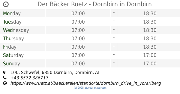
Der Bäcker Ruetz - Dornbirn
Schwefel 100, Dornbirn
Bakery
read more
2.927 km
Bäckerei Mangold
Achstraße 42, Wolfurt
Bakery
read more
3.794 km
Der Bäcker Ruetz - Lauterach
Harderstraße 54, Lauterach
Bakery
read more
4.114 km
Kloser's Bäckerei GmbH
Gallusstraße 51, Bregenz
Bakery
read more
4.465 km
Bag GesmbH
Brielgasse 18, Bregenz
Bakery
read more
4.54 km
Fitz Bäckerei e.U.
Eisengasse 25, Dornbirn
Bakery
read more
4.922 km
Schertlerbrot GmbH & Co KG
Marktplatz 1, Dornbirn
Bakery
read more
4.955 km
Bäckerei Konditorei Josef Schertler
Marktstraße 1, Dornbirn
Bakery
read more
5.001 km
Gebhard Fetz
Quellenstraße 18, Hard
Bakery
read more
5.1 km
Bäckerei Mangold
Gemeinde, Hard
Bakery
read more
5.113 km
Bäckerei Mangold
Rheinstraße 2, Hard
Bakery
read more
6.146 km
Bäckerei Kainz
Steinlochstraße 13, Hard
Bakery
read more
📑
all categories
Accounting
Administrative area level 1
Administrative area level 2
Airport
Amusement park
Aquarium
Art gallery
Atm
Bakery
Bank
Bar
Beauty salon
Bicycle store
Book store
Bowling alley
Bus station
Cafe
Campground
Car dealer
Car rental
Car repair
Car wash
Casino
Cemetery
Church
City hall
Clothing store
Colloquial area
Convenience store
Country
Courthouse
Dentist
Department store
Doctor
Electrician
Electronics store
Embassy
Finance
Fire station
Florist
Food
Funeral home
Furniture store
Gas station
General contractor
Grocery or supermarket
Gym
Hair care
Hardware store
Health
Hindu Temple
Home goods store
Hospital
Insurance agency
Jewelry store
Laundry
Lawyer
Library
Light rail station
Liquor store
Local government office
Locality
Locksmith
Lodging
Meal delivery
Meal takeaway
Mosque
Movie rental
Movie theater
Moving company
Museum
Natural feature
Neighborhood
Night club
Painter
Park
Parking
Pet store
Pharmacy
Physiotherapist
Place of worship
Plumber
Point of interest
Police
Political
Post office
Premise
Real estate agency
Restaurant
Roofing contractor
Route
Rv park, camping
School
Shoe store
Shopping mall
Spa
Stadium
Storage
Store
Subpremise
Subway station
Supermarket
Synagogue
Taxi stand
Train station
Transit station
Travel agency
University
Veterinary care
Zoo
administrative area level 3
sublocality level 1
↑