Bar nearby Baguette
Austria
Bar nearby Baguette
Baguette
Pradler Straße 72, Innsbruck Austria
contacts phone
:
+43
Latitude:
47.2635631
, Longitude:
11.4104237
read more
nearest Bar
170 m
Tiki Taka
1, Gumppstraße, Innsbruck
Bar
read more
277 m
Karl Janesch
Defreggerstraße 37, Innsbruck
Bar
read more
522 m
Club Cavall
Amraser Straße 6, Innsbruck
Bar
read more
546 m
LUCKY Sport-Wetten
Amraser Straße 6, Innsbruck
Bar
read more
594 m
Sportsbar Olympiahalle
Olympiastraße 10, Innsbruck
Bar
read more
706 m
Jugendheim Pradl
Reichenauer Straße 15, Innsbruck
Bar
read more
741 m
Ledio Nicntl
Brunecker Straße 3, Innsbruck
Bar
read more
744 m
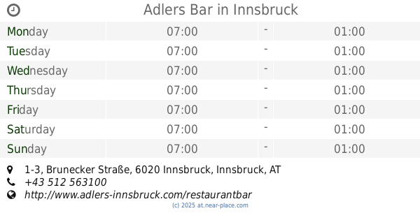
Adlers Bar
Brunecker Straße 1-3, Innsbruck
Bar
read more
751 m
Jellyfish Music.Bar
Ingenieur-Etzel-Straße 13, Innsbruck
Bar
read more
766 m
PlanB
Ingenieur-Etzel-Straße 15, Innsbruck
Bar
read more
789 m
Abyss Bar
Amraser-See-Straße 5, Innsbruck
Bar
read more
798 m
Cafe-Bar Babalon
Ingenieur-Etzel-Straße 22, Innsbruck
Bar
read more
807 m
Down Under
Ingenieur-Etzel-Straße 22, Innsbruck
Bar
read more
814 m
Ayson Aksoy KEG
Museumstraße 34, Innsbruck
Bar
read more
862 m
Jazzbar BRXN
Brixner Straße 4, Innsbruck
Bar
read more
917 m
mfg Bar
Adamgasse 13, Innsbruck
Bar
read more
975 m
Huber Yellowstone KEG
Ingenieur-Etzel-Straße 50, Innsbruck
Bar
read more
991 m
Bar Kir Royal
Sillgasse 11, Innsbruck
Bar
read more
1.025 km
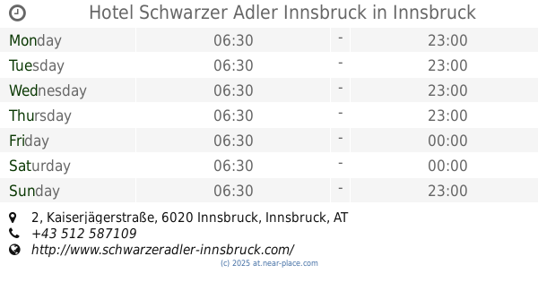
Hotel Schwarzer Adler Innsbruck
Kaiserjägerstraße 2, Innsbruck
Bar
read more
1.043 km
The Galway Bay
Kaiserjägerstraße 4, Innsbruck
Bar
read more
1.052 km
Cafe-Bar Kapuziner Innsbruck
Kaiserjägerstraße 4a, Innsbruck
Bar
read more
1.069 km
Café Bar Dinzler
Kaiserjägerstraße 1, Innsbruck
Bar
read more
1.091 km
Cafe Platzl
Mentlgasse 4, Innsbruck
Bar
read more
1.095 km
06 zerOsei
Universitätsstraße 15b, Innsbruck
Bar
read more
1.195 km
Rote Laterne
Neurauthgasse 5, Innsbruck
Bar
read more
📑
all categories
Accounting
Administrative area level 1
Administrative area level 2
Airport
Amusement park
Aquarium
Art gallery
Atm
Bakery
Bank
Bar
Beauty salon
Bicycle store
Book store
Bowling alley
Bus station
Cafe
Campground
Car dealer
Car rental
Car repair
Car wash
Casino
Cemetery
Church
City hall
Clothing store
Colloquial area
Convenience store
Country
Courthouse
Dentist
Department store
Doctor
Electrician
Electronics store
Embassy
Finance
Fire station
Florist
Food
Funeral home
Furniture store
Gas station
General contractor
Grocery or supermarket
Gym
Hair care
Hardware store
Health
Hindu Temple
Home goods store
Hospital
Insurance agency
Jewelry store
Laundry
Lawyer
Library
Light rail station
Liquor store
Local government office
Locality
Locksmith
Lodging
Meal delivery
Meal takeaway
Mosque
Movie rental
Movie theater
Moving company
Museum
Natural feature
Neighborhood
Night club
Painter
Park
Parking
Pet store
Pharmacy
Physiotherapist
Place of worship
Plumber
Point of interest
Police
Political
Post office
Premise
Real estate agency
Restaurant
Roofing contractor
Route
Rv park, camping
School
Shoe store
Shopping mall
Spa
Stadium
Storage
Store
Subpremise
Subway station
Supermarket
Synagogue
Taxi stand
Train station
Transit station
Travel agency
University
Veterinary care
Zoo
administrative area level 3
sublocality level 1
↑