Bar nearby biker's inn
Austria
Bar nearby biker's inn
biker's inn
Hauptstrasse 65, Rheineck Austria
contacts phone
:
+43
Latitude:
47.464264
, Longitude:
9.5928308
read more
nearest Bar
457 m
Pazzo Bar & Lounge CLUB
Poststrasse 1, Rheineck
Bar
read more
1.758 km
Wurzel Pub
Rheineckerstrasse 2, Thal
Bar
read more
1.82 km
Clublokal Engel; V8 Club Thal
Rathausweg 3, Thal
Bar
read more
2.31 km
Stadel
Bäumlestraße 75, Höchst
Bar
read more
3.685 km
Online Bar
Johannes-Brasselstrasse 15, Sankt Margrethen
Bar
read more
4.459 km
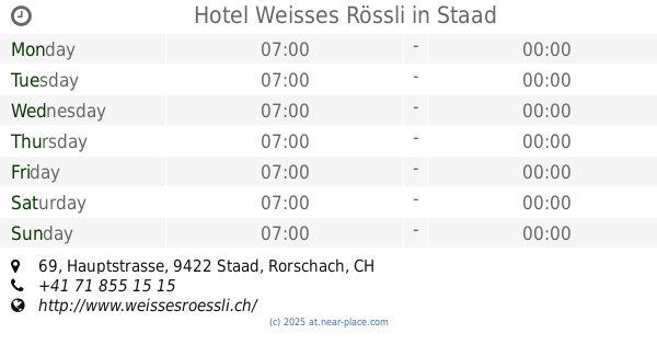
Bodenseehotel Weisses Rössli
Hauptstrasse 69, Staad
Bar
read more
4.459 km
Hotel Weisses Rössli
Hauptstrasse 69, Staad
Bar
read more
4.663 km
Marimar Tapas Bar & Lounge
Hinterergeten 709, Wolfhalden
Bar
read more
4.674 km
White Horse Pub
Hauptstrasse 61, Au
Bar
read more
4.709 km
52 Magic Bar
Rheinstrasse 3, Au
Bar
read more
4.799 km
Riva Bar
Hauptstrasse 98, Au
Bar
read more
4.83 km
Pascha
Hauptstrasse 40, Staad
Bar
read more
4.939 km
Cafe-Bar Plauderer
Bundesstraße 63, Höchst
Bar
read more
4.995 km
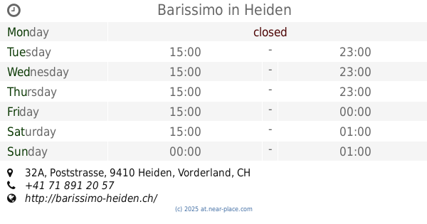
Barissimo
Poststrasse 32A, Heiden
Bar
read more
5.038 km
Graffiti Bar
Staad, Hauptstrasse 7, Staad
Bar
read more
5.517 km
Brigitte Giovannini
Reichsstraße 46, Lustenau
Bar
read more
5.603 km
Houky
Dorfstrasse 7, Oberegg
Bar
read more
5.618 km
Culture Factor Y autonomer Jugend- u Kulturverein Lustenau
Amann-Fitz-Straße 6, Lustenau
Bar
read more
5.989 km
Harlekin
Radetzkystr. 5, Lustenau
Bar
read more
6.12 km
Fränkis
Widum 19, Lustenau
Bar
read more
8.191 km
Pumpwerk Hardcore Gym
Pumpwerk 9400, Industriestrasse 41A, Rorschach
Bar
read more
12.841 km
D' Kellerbar
Schmelzhütterstraße 5, Dornbirn
Bar
read more
13.031 km
S'Pub
Am Dorfplatz 4, Schwarzach
Bar
read more
13.436 km
Towerbar
Zanzenberggasse 2, Dornbirn
Bar
read more
15.408 km
Arguna
Eisenbahnstraße 23, Langenargen
Bar
read more
📑
all categories
Accounting
Administrative area level 1
Administrative area level 2
Airport
Amusement park
Aquarium
Art gallery
Atm
Bakery
Bank
Bar
Beauty salon
Bicycle store
Book store
Bowling alley
Bus station
Cafe
Campground
Car dealer
Car rental
Car repair
Car wash
Casino
Cemetery
Church
City hall
Clothing store
Colloquial area
Convenience store
Country
Courthouse
Dentist
Department store
Doctor
Electrician
Electronics store
Embassy
Finance
Fire station
Florist
Food
Funeral home
Furniture store
Gas station
General contractor
Grocery or supermarket
Gym
Hair care
Hardware store
Health
Hindu Temple
Home goods store
Hospital
Insurance agency
Jewelry store
Laundry
Lawyer
Library
Light rail station
Liquor store
Local government office
Locality
Locksmith
Lodging
Meal delivery
Meal takeaway
Mosque
Movie rental
Movie theater
Moving company
Museum
Natural feature
Neighborhood
Night club
Painter
Park
Parking
Pet store
Pharmacy
Physiotherapist
Place of worship
Plumber
Point of interest
Police
Political
Post office
Premise
Real estate agency
Restaurant
Roofing contractor
Route
Rv park, camping
School
Shoe store
Shopping mall
Spa
Stadium
Storage
Store
Subpremise
Subway station
Supermarket
Synagogue
Taxi stand
Train station
Transit station
Travel agency
University
Veterinary care
Zoo
administrative area level 3
sublocality level 1
↑