Bar nearby Fiakerstüberl
Austria
Bar nearby Fiakerstüberl
Fiakerstüberl
Leonfeldner Straße 38, Linz Austria
contacts phone
:
+43
Latitude:
48.3217017
, Longitude:
14.2833038
read more
nearest Bar
444 m
Oldie Musik Beisl
Leonfeldner Straße 1, Linz
Bar
read more
723 m
Jugendzentrum U1
Hauptstraße 74, Linz
Bar
read more
729 m
Tanzbar Casablanca
Hauptstraße 74, Linz
Bar
read more
813 m
CASTELLO DEL VINO Lentia City
Blütenstraße 15, Linz
Bar
read more
966 m
Cheers
Hauptstraße 42, Linz
Bar
read more
971 m
Golden Pub
Jahnstraße 9, Linz
Bar
read more
1.053 km
Buffet Auer
Leonfeldner Straße 97, Linz
Bar
read more
1.053 km
Buffet Auer
Leonfeldner Str. 97, Linz
Bar
read more
1.118 km
Gasthaus Limberger
Am Anger, Blindwiesen 5, Linz
Bar
read more
1.14 km
ADMIRAL Filiale
Rudolfstraße 4-6, Linz
Bar
read more
1.279 km
Cafe Strom
Kirchengasse 4, Linz
Bar
read more
1.393 km
KÉ café & bar
Untere Donaulände 9, Linz
Bar
read more
1.563 km
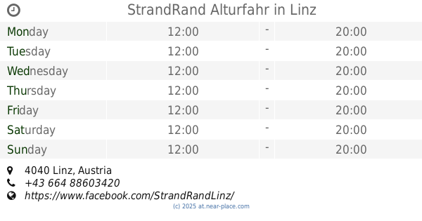
StrandRand Alturfahr
Linz
Bar
read more
1.603 km
Sisi-Top
Untere Donaulände 8, Linz
Bar
read more
1.687 km
Leopoldistüberl der Beer Buddies Brewing Company
Adlergasse 6, Linz
Bar
read more
1.718 km
Bar Neuf
Rathausgasse 9, Linz
Bar
read more
1.719 km
GinChilla
Hofberg 5, Linz
Bar
read more
1.725 km
Linzerl
Hofberg 5, Linz
Bar
read more
1.728 km
Bar Keintzel
Rathausgasse 3, Linz
Bar
read more
1.735 km
Tempelbar
Hofberg 6, Linz
Bar
read more
1.741 km
Gallanderstüberl
Gallanderstraße 3, Linz
Bar
read more
1.805 km
Weinstadl Urfahr
Griesmayrstraße 18, Linz
Bar
read more
1.824 km
Aps
Hahnengasse 5, Linz
Bar
read more
1.88 km
Cafe Aquarium
Altstadt 22, Linz
Bar
read more
1.95 km
Lennox
Marienstraße 2a, Linz
Bar
read more
📑
all categories
Accounting
Administrative area level 1
Administrative area level 2
Airport
Amusement park
Aquarium
Art gallery
Atm
Bakery
Bank
Bar
Beauty salon
Bicycle store
Book store
Bowling alley
Bus station
Cafe
Campground
Car dealer
Car rental
Car repair
Car wash
Casino
Cemetery
Church
City hall
Clothing store
Colloquial area
Convenience store
Country
Courthouse
Dentist
Department store
Doctor
Electrician
Electronics store
Embassy
Finance
Fire station
Florist
Food
Funeral home
Furniture store
Gas station
General contractor
Grocery or supermarket
Gym
Hair care
Hardware store
Health
Hindu Temple
Home goods store
Hospital
Insurance agency
Jewelry store
Laundry
Lawyer
Library
Light rail station
Liquor store
Local government office
Locality
Locksmith
Lodging
Meal delivery
Meal takeaway
Mosque
Movie rental
Movie theater
Moving company
Museum
Natural feature
Neighborhood
Night club
Painter
Park
Parking
Pet store
Pharmacy
Physiotherapist
Place of worship
Plumber
Point of interest
Police
Political
Post office
Premise
Real estate agency
Restaurant
Roofing contractor
Route
Rv park, camping
School
Shoe store
Shopping mall
Spa
Stadium
Storage
Store
Subpremise
Subway station
Supermarket
Synagogue
Taxi stand
Train station
Transit station
Travel agency
University
Veterinary care
Zoo
administrative area level 3
sublocality level 1
↑