Bar nearby Gasthaus Gärtnerwirt
Coronavirus disease (COVID-19) Situation
confirmed cases
6081287
deaths
22542
Austria
Bar nearby Gasthaus Gärtnerwirt
Gasthaus Gärtnerwirt
Plainstraße 93, Salzburg Austria
contacts phone
:
+43
Latitude:
47.8189556
, Longitude:
13.0406046
read more
nearest Bar
282 m
Itzlinger Hof
Itzlinger Hauptstraße 11, Salzburg
Bar
read more
521 m
2 Face Bar Cafe & Lounge
Jahnstraße 19, Salzburg
Bar
read more
608 m
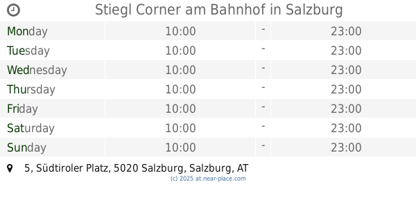
Stiegl Corner am Bahnhof
Südtiroler Platz 5, Salzburg
Bar
read more
653 m
Elisabethstüberl
Elisabethstraße 21, Salzburg
Bar
read more
746 m
Pub zum Stern
Franz-Martin-Straße 33, Salzburg
Bar
read more
796 m
Brothers Lounge - Shisha Bar
Elisabethstraße 6A, Salzburg
Bar
read more
899 m
Muschelwirt
Salzburg
Bar
read more
925 m
Cestlavie@Schweiger
Itzlinger Hauptstraße 93, Salzburg
Bar
read more
929 m
ADMIRAL Filiale
Itzlinger Hauptstraße 93, Salzburg
Bar
read more
1.003 km
Cashpoint Salzburg
Rainerstraße 24, Salzburg
Bar
read more
1.006 km
Pelikan Gastro Kg
Ignaz-Harrer-Straße 16, Salzburg
Bar
read more
1.082 km
Arkadaş Grillhaus
Ignaz-Harrer-Straße 30, Salzburg
Bar
read more
1.126 km
Cafe Bar Lounge Focus
Ignaz-Harrer-Straße 38, Salzburg
Bar
read more
1.142 km
Rosseggerstüberl
Roseggerstraße 14, Salzburg
Bar
read more
1.202 km
Dart Factory
Ignaz-Harrer-Straße 31, Salzburg
Bar
read more
1.225 km
Crowne Plaza Salzburg - The Pitter
Rainerstraße 6-8, Salzburg
Bar
read more
1.242 km
The Plaza
6, Rainerstraße, Salzburg
Bar
read more
1.275 km
Musa's Musik Pub
Ignaz-Harrer-Straße 48, Salzburg
Bar
read more
1.708 km
Servus Tagesbar Christine Sappl
Bergstraße 18, Salzburg
Bar
read more
1.764 km
Beffa Bar
Bergstraße 13, Salzburg
Bar
read more
1.791 km
Coffee & Booze
Linzer Gasse 48, Salzburg
Bar
read more
1.869 km
Studio68
Bachstraße 68, Salzburg
Bar
read more
1.891 km
Laterndl-Bar
Innsbrucker Bundesstraße 5A, Salzburg
Bar
read more
1.957 km
Russ Bar
Gstättengasse 25, Salzburg
Bar
read more
1.967 km
SEGABAR Gstättengasse
Gstättengasse 23, Salzburg
Bar
read more
📑
all categories
Accounting
Administrative area level 1
Administrative area level 2
Airport
Amusement park
Aquarium
Art gallery
Atm
Bakery
Bank
Bar
Beauty salon
Bicycle store
Book store
Bowling alley
Bus station
Cafe
Campground
Car dealer
Car rental
Car repair
Car wash
Casino
Cemetery
Church
City hall
Clothing store
Colloquial area
Convenience store
Country
Courthouse
Dentist
Department store
Doctor
Electrician
Electronics store
Embassy
Finance
Fire station
Florist
Food
Funeral home
Furniture store
Gas station
General contractor
Grocery or supermarket
Gym
Hair care
Hardware store
Health
Hindu Temple
Home goods store
Hospital
Insurance agency
Jewelry store
Laundry
Lawyer
Library
Light rail station
Liquor store
Local government office
Locality
Locksmith
Lodging
Meal delivery
Meal takeaway
Mosque
Movie rental
Movie theater
Moving company
Museum
Natural feature
Neighborhood
Night club
Painter
Park
Parking
Pet store
Pharmacy
Physiotherapist
Place of worship
Plumber
Point of interest
Police
Political
Post office
Premise
Real estate agency
Restaurant
Roofing contractor
Route
Rv park, camping
School
Shoe store
Shopping mall
Spa
Stadium
Storage
Store
Subpremise
Subway station
Supermarket
Synagogue
Taxi stand
Train station
Transit station
Travel agency
University
Veterinary care
Zoo
administrative area level 3
sublocality level 1
↑