Bar nearby Meister's Stüble
Austria
Bar nearby Meister's Stüble
Meister's Stüble
Rickenbacher Straße 47, Lindau (Bodensee) Austria
contacts phone
:
+43
Latitude:
47.5557097
, Longitude:
9.7097716
read more
nearest Bar
635 m
Pharao Bar II
Germany
Bar
read more
1.123 km
PUB-Coaching Patricia Bodler
Kemptener Straße 114, Lindau (Bodensee)
Bar
read more
1.317 km
Vip Club Pharao Bar
Germany
Bar
read more
1.811 km
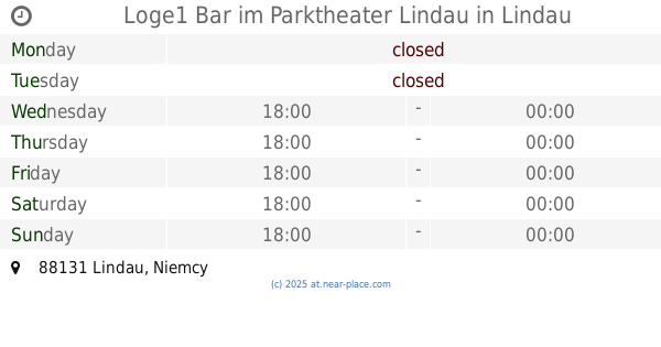
Loge1 Bar im Parktheater Lindau
Lindau
Bar
read more
1.823 km
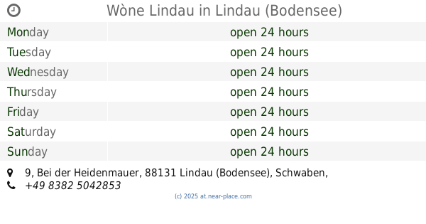
Wòne Lindau
Bei der Heidenmauer 9, Lindau (Bodensee)
Bar
read more
1.93 km
Barbarista
Marktplatz 1, Lindau (Bodensee)
Bar
read more
1.968 km
Hotel Gasthof Stift
Stiftsplatz 1, Lindau (Bodensee)
Bar
read more
1.981 km
City-Pub
Marktplatz 5, Lindau , Bodensee
Bar
read more
1.999 km
Theater-Bar Lindau
An der Kalkhütte 2a, Lindau (Bodensee)
Bar
read more
2.125 km
Scotch Club Lindau
Hofstattgasse 2, Lindau (Bodensee)
Bar
read more
2.148 km
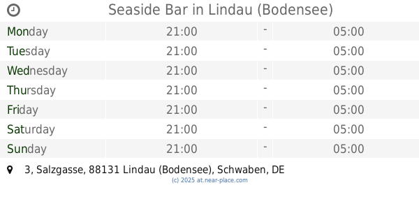
Seaside Bar
Salzgasse 3, Lindau (Bodensee)
Bar
read more
2.157 km
Rathausbar Lindau
Salzgasse 2, Lindau (Bodensee)
Bar
read more
2.161 km
Café Ristorante Da Capo
Bürstergasse 1, Lindau (Bodensee)
Bar
read more
2.163 km
E. Hauser Cafe
Bürstergasse 1, Lindau (Bodensee)
Bar
read more
2.169 km
Mike's Irish Pub
In der Grub 34, Lindau (Bodensee)
Bar
read more
2.198 km
Zur Alten Werft - Biergarten
Lindau (Bodensee)
Bar
read more
2.239 km
Hotel Engel
Schafgasse 4, Lindau (Bodensee)
Bar
read more
2.303 km
Treibgut
Vordere Metzgergasse 14, Lindau (Bodensee)
Bar
read more
2.369 km
Coco Loco Bar
Ludwigstraße 42, Lindau (Bodensee)
Bar
read more
2.373 km
Bar Da Valerio
Maximilianstraße 48, Lindau (Bodensee)
Bar
read more
2.389 km
Zur Fischerin
Ludwigstraße 50, Lindau (Bodensee)
Bar
read more
2.474 km
Gasthaus 's Sannwald
Lochauer Straße 2, Gemeinde Hörbranz
Bar
read more
2.52 km
Marmorsaal – Café, Bar, Club & Gastronomie
Bahnhofplatz 1, Lindau (Bodensee)
Bar
read more
3.209 km
Leiblachtaler Harleyaner
Gemeinde Hörbranz
Bar
read more
3.209 km
Leiblachtaler Harleyaner
Hörbranz
Bar
read more
📑
all categories
Accounting
Administrative area level 1
Administrative area level 2
Airport
Amusement park
Aquarium
Art gallery
Atm
Bakery
Bank
Bar
Beauty salon
Bicycle store
Book store
Bowling alley
Bus station
Cafe
Campground
Car dealer
Car rental
Car repair
Car wash
Casino
Cemetery
Church
City hall
Clothing store
Colloquial area
Convenience store
Country
Courthouse
Dentist
Department store
Doctor
Electrician
Electronics store
Embassy
Finance
Fire station
Florist
Food
Funeral home
Furniture store
Gas station
General contractor
Grocery or supermarket
Gym
Hair care
Hardware store
Health
Hindu Temple
Home goods store
Hospital
Insurance agency
Jewelry store
Laundry
Lawyer
Library
Light rail station
Liquor store
Local government office
Locality
Locksmith
Lodging
Meal delivery
Meal takeaway
Mosque
Movie rental
Movie theater
Moving company
Museum
Natural feature
Neighborhood
Night club
Painter
Park
Parking
Pet store
Pharmacy
Physiotherapist
Place of worship
Plumber
Point of interest
Police
Political
Post office
Premise
Real estate agency
Restaurant
Roofing contractor
Route
Rv park, camping
School
Shoe store
Shopping mall
Spa
Stadium
Storage
Store
Subpremise
Subway station
Supermarket
Synagogue
Taxi stand
Train station
Transit station
Travel agency
University
Veterinary care
Zoo
administrative area level 3
sublocality level 1
↑