Bar nearby Palmira
Austria
Bar nearby Palmira
Palmira
Hauptplatz 19, Baden Ausztria
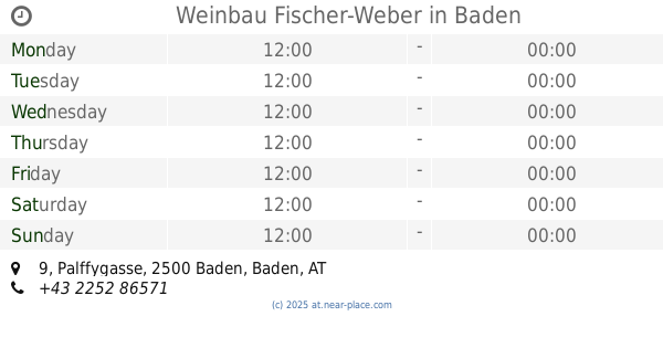
contacts phone
:
+43
Latitude:
48.0073348
, Longitude:
16.2343358
read more
nearest Bar
133 m
Mojo
Josefsplatz 3, Baden
Bar
read more
144 m
Cool me
3, Josefsplatz, Baden
Bar
read more
175 m
Bluhmuhn
Erzherzog Rainer-Ring 3, Baden
Bar
read more
184 m
Genusseria
7, Pfarrgasse, Baden
Bar
read more
193 m
d'2
Grüner Markt, Brusattiplatz, Baden
Bar
read more
196 m
Il gusto Genuss Hütte
Erzherzog Rainer-Ring 9, Baden
Bar
read more
202 m
Zum Wilderer
Baden bei Wien
Bar
read more
202 m
Zum Wilderer
Baden
Bar
read more
250 m
la bodeguita
Erzherzog Rainer-Ring 13, Baden
Bar
read more
317 m
big11 Burger Restaurant
Vöslauer Straße 4, Baden
Bar
read more
326 m
Tomate Baden - Szenelokal und Partytreff
Vöslauer Straße 4/2, Baden
Bar
read more
628 m
Winegrowing family Ramberger
Mühlgasse 14, Baden
Bar
read more
628 m
Weinbau Familie Ramberger
Mühlgasse 14, Baden
Bar
read more
640 m
Weinbau Fischer-Weber
Palffygasse 9, Baden
Bar
read more
693 m
Weingut Mayer
Weichselgasse 24, Baden
Bar
read more
695 m
Weinbau- und Kellermeister Adolf J. Mayer
Weichselgasse 24, Baden
Bar
read more
852 m
Weinbau Eitler Rudolf
Ferdinand Pichler-Gasse 10, Baden
Bar
read more
884 m
OLDIES
Waltersdorfer Straße 3, Baden
Bar
read more
921 m
Heurigen Reiser
Braitner Straße 72, Baden
Bar
read more
945 m
Weingut Franz Schwabl
Germergasse 25, Baden
Bar
read more
959 m
Weingut Breyer
Klesheimstraße 11 / Rohrgasse 18, Rohrgasse 18, Baden
Bar
read more
992 m
Weinbau u Buschenschank Schuster
Vöslauer Straße 58, Baden
Bar
read more
1.02 km
Weinbau Ceidl
Wiener Straße 42, Baden
Bar
read more
1.043 km
Helmut Freisinger
Gaminger Berg 3, Baden
Bar
read more
1.071 km
Galenos
Vöslauer Straße 66, Baden
Bar
read more
📑
all categories
Accounting
Administrative area level 1
Administrative area level 2
Airport
Amusement park
Aquarium
Art gallery
Atm
Bakery
Bank
Bar
Beauty salon
Bicycle store
Book store
Bowling alley
Bus station
Cafe
Campground
Car dealer
Car rental
Car repair
Car wash
Casino
Cemetery
Church
City hall
Clothing store
Colloquial area
Convenience store
Country
Courthouse
Dentist
Department store
Doctor
Electrician
Electronics store
Embassy
Finance
Fire station
Florist
Food
Funeral home
Furniture store
Gas station
General contractor
Grocery or supermarket
Gym
Hair care
Hardware store
Health
Hindu Temple
Home goods store
Hospital
Insurance agency
Jewelry store
Laundry
Lawyer
Library
Light rail station
Liquor store
Local government office
Locality
Locksmith
Lodging
Meal delivery
Meal takeaway
Mosque
Movie rental
Movie theater
Moving company
Museum
Natural feature
Neighborhood
Night club
Painter
Park
Parking
Pet store
Pharmacy
Physiotherapist
Place of worship
Plumber
Point of interest
Police
Political
Post office
Premise
Real estate agency
Restaurant
Roofing contractor
Route
Rv park, camping
School
Shoe store
Shopping mall
Spa
Stadium
Storage
Store
Subpremise
Subway station
Supermarket
Synagogue
Taxi stand
Train station
Transit station
Travel agency
University
Veterinary care
Zoo
administrative area level 3
sublocality level 1
↑