Bar nearby Verena’s Bar
Austria
Bar nearby Verena’s Bar
Verena’s Bar
Gießenweg 15, Völs Ausztria
contacts phone
:
+43
Latitude:
47.2558906
, Longitude:
11.3254753
read more
nearest Bar
54 m
Caro's Snack Bar and Breakfast
Gießenweg 15, Völs
Bar
read more
181 m
Die Steireria
Cytastraße 4, Völs
Bar
read more
645 m
Café Bar Rosso
Völs
Bar
read more
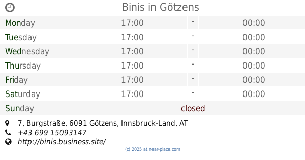
2.333 km
Binis
Burgstraße 7, Götzens
Bar
read more
2.333 km
Bini's Bar
Burgstraße 7, Götzens
Bar
read more
2.338 km
Binis's Bar Götzens
Burgstraße 7, Götzens
Bar
read more
2.789 km
Kupferpfandl
Kranebitter Allee 88, Innsbruck
Bar
read more
2.789 km
Club Diamond
Kranebitter Allee 88, Innsbruck
Bar
read more
3.319 km
Runner Runner Innsbruck, Austria
Angergasse, Innsbruck
Bar
read more
3.927 km
Bar/Cafe Karwendelbogen 33
Karwendelbögen 33, Innsbruck
Bar
read more
3.927 km
Cafe GALAXY
Karwendelbögen 33-35, Innsbruck
Bar
read more
4.238 km
Monroes Bar
Innrain 87, Innsbruck
Bar
read more
4.566 km
Vaca Loca
Blasius-Hueber-Straße 16, Innsbruck
Bar
read more
4.696 km
G's Brothel
Egger-Lienz-Straße 48, Innsbruck
Bar
read more
4.796 km
Hotel & Restaurant Kögele
Georg-Bucher-Straße 34, Axams
Bar
read more
4.806 km
Glockengießer
Bachgasse 14, Innsbruck
Bar
read more
4.91 km
Nachtschwärmer
Innsbrucker Straße 22-24, Innsbruck
Bar
read more
4.929 km
Hutmacher´s Bar
Innrain 28, Innsbruck
Bar
read more
4.99 km
Moksh cafe bar
Schöpfstrasse, Innsbruck
Bar
read more
4.99 km
vinum.in
Herzog-Siegmund-Ufer 1-3, Innsbruck
Bar
read more
5.055 km
John Montagu
Höttinger Gasse 7, Innsbruck
Bar
read more
5.068 km
ZwanzigZwoelf
Mariahilfstraße 8, Innsbruck
Bar
read more
5.125 km
Tapabar
Innrain 2, Innsbruck
Bar
read more
5.242 km
M + M Bar - cocktail bar in Innsbruck
Innstraße 45, Innsbruck
Bar
read more
5.254 km
Cafe Bar Bierkrügerl
Innstraße 49, Innsbruck
Bar
read more
📑
all categories
Accounting
Administrative area level 1
Administrative area level 2
Airport
Amusement park
Aquarium
Art gallery
Atm
Bakery
Bank
Bar
Beauty salon
Bicycle store
Book store
Bowling alley
Bus station
Cafe
Campground
Car dealer
Car rental
Car repair
Car wash
Casino
Cemetery
Church
City hall
Clothing store
Colloquial area
Convenience store
Country
Courthouse
Dentist
Department store
Doctor
Electrician
Electronics store
Embassy
Finance
Fire station
Florist
Food
Funeral home
Furniture store
Gas station
General contractor
Grocery or supermarket
Gym
Hair care
Hardware store
Health
Hindu Temple
Home goods store
Hospital
Insurance agency
Jewelry store
Laundry
Lawyer
Library
Light rail station
Liquor store
Local government office
Locality
Locksmith
Lodging
Meal delivery
Meal takeaway
Mosque
Movie rental
Movie theater
Moving company
Museum
Natural feature
Neighborhood
Night club
Painter
Park
Parking
Pet store
Pharmacy
Physiotherapist
Place of worship
Plumber
Point of interest
Police
Political
Post office
Premise
Real estate agency
Restaurant
Roofing contractor
Route
Rv park, camping
School
Shoe store
Shopping mall
Spa
Stadium
Storage
Store
Subpremise
Subway station
Supermarket
Synagogue
Taxi stand
Train station
Transit station
Travel agency
University
Veterinary care
Zoo
administrative area level 3
sublocality level 1
↑