Bar nearby Whisky-Mühle, Gars am Kamp
Austria
Bar nearby Whisky-Mühle, Gars am Kamp
Whisky-Mühle, Gars am Kamp
Babenbergerstraße 52, Gars am Kamp Austria
contacts phone
:
+43
Latitude:
48.5953106
, Longitude:
15.6585143
read more
nearest Bar
25 m
Minigolfplatz
Gars am Kamp
Bar
read more
402 m
Kraftwerk
Kremserstraße 44a, Gars am Kamp
Bar
read more
484 m
zur Manu
Hornerstraße 702, Gars am Kamp
Bar
read more
5.78 km
Heuriger Fam. Diewald
Altenhof 11, Altenhof
Bar
read more
5.98 km
Sportkegelbahn Mold
Lorenz Hafner, Pivonkaweg 1, Mold
Bar
read more
7.105 km
Robert Breit
Hauptstraße, Stiefern
Bar
read more
7.382 km
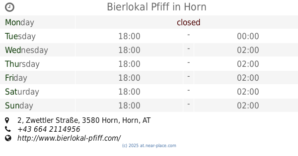
Bierlokal Pfiff
Zwettler Straße 2, Horn
Bar
read more
7.559 km
ADMIRAL Sportsbar
Wiener Straße 81, Horn
Bar
read more
7.626 km
B4 Bar
Wiener Straße 69, Horn
Bar
read more
7.734 km
Achterbar
Florianigasse 8, Horn
Bar
read more
7.756 km
Cafe Carambol Horn
Thurnhofgasse 14, Horn
Bar
read more
7.756 km
Carambol
Thurnhofgasse 14, Horn
Bar
read more
7.763 km
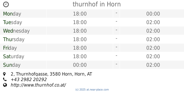
thurnhof
Thurnhofgasse 2, Horn
Bar
read more
8.176 km
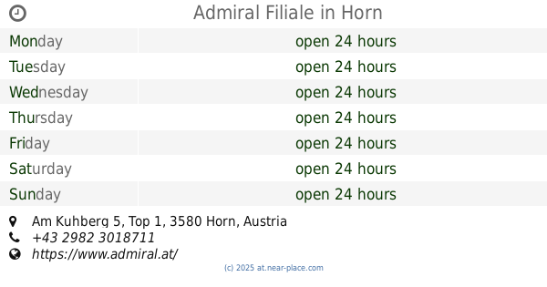
Admiral Filiale
Am Kuhberg 5, Top 1, Horn
Bar
read more
8.234 km
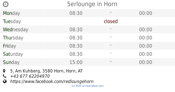
5erlounge
Am Kuhberg 5, Horn
Bar
read more
8.954 km
Weinbeisserei & Winzer Hager Matthias ab Hof Verkauf
Mollands 84, Mollands
Bar
read more
9.253 km
Schräger Vogel
Auf der Leiten 1, Mollands
Bar
read more
10.444 km
Buschenschank Hager
Klein Meiseldorf 7, Kleinmeiseldorf
Bar
read more
11.144 km
Heuriger Forster
Hauptstraße 62, Rodingersdorf
Bar
read more
11.529 km
Heuriger am Berg Ludwig und Michael Gruber
Mittelberg 41, Langenlois
Bar
read more
11.878 km
Jogl-Keller
Zöbinger Hauptstraße 45, Langenlois
Bar
read more
14.374 km
Feuerwehrfestival - Vorglühstage
Lengenfeld
Bar
read more
15.89 km
Heuriger Nigl
Am Platzl 73, Droß
Bar
read more
15.944 km
Zum alten Bierkeller
Hauptstraße 81, Droß
Bar
read more
15.944 km
Gasthof zum alten Bierkeller
Hauptstraße 81, Droß
Bar
read more
📑
all categories
Accounting
Administrative area level 1
Administrative area level 2
Airport
Amusement park
Aquarium
Art gallery
Atm
Bakery
Bank
Bar
Beauty salon
Bicycle store
Book store
Bowling alley
Bus station
Cafe
Campground
Car dealer
Car rental
Car repair
Car wash
Casino
Cemetery
Church
City hall
Clothing store
Colloquial area
Convenience store
Country
Courthouse
Dentist
Department store
Doctor
Electrician
Electronics store
Embassy
Finance
Fire station
Florist
Food
Funeral home
Furniture store
Gas station
General contractor
Grocery or supermarket
Gym
Hair care
Hardware store
Health
Hindu Temple
Home goods store
Hospital
Insurance agency
Jewelry store
Laundry
Lawyer
Library
Light rail station
Liquor store
Local government office
Locality
Locksmith
Lodging
Meal delivery
Meal takeaway
Mosque
Movie rental
Movie theater
Moving company
Museum
Natural feature
Neighborhood
Night club
Painter
Park
Parking
Pet store
Pharmacy
Physiotherapist
Place of worship
Plumber
Point of interest
Police
Political
Post office
Premise
Real estate agency
Restaurant
Roofing contractor
Route
Rv park, camping
School
Shoe store
Shopping mall
Spa
Stadium
Storage
Store
Subpremise
Subway station
Supermarket
Synagogue
Taxi stand
Train station
Transit station
Travel agency
University
Veterinary care
Zoo
administrative area level 3
sublocality level 1
↑