Cafe nearby Cafe Pub Boxenstop
Austria
Cafe nearby Cafe Pub Boxenstop
Cafe Pub Boxenstop
Waldeben 3, Weerberg Østrig
contacts phone
:
+43
Latitude:
47.3152439
, Longitude:
11.6795684
read more
nearest Cafe
2.156 km
Cafe Central
Mitterberg 115, Weerberg
Cafe
read more
3.031 km
Gasthaus Pelikan
Dorf 74, Vomp
Cafe
read more
3.712 km
Cafe Galerie
Silberregion Karwendel, Doktor-Walter-Waizer-Straße 5, Schwaz
Cafe
read more
3.812 km
Ton Art
Innsbrucker Straße 16, Schwaz
Cafe
read more
3.908 km
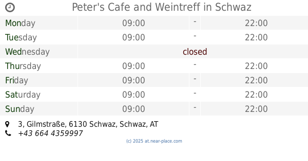
Peter's Cafe and Weintreff
Gilmstraße 3, Schwaz
Cafe
read more
3.915 km
Cafe Radio
Andreas Hofer Straße 3, Schwaz
Cafe
read more
3.946 km
Weingerecht
Burggasse 4, Schwaz
Cafe
read more
3.954 km
coffein
Franz-Josef-Straße 1, Schwaz
Cafe
read more
3.957 km
Cafe Silver City Saloon
Franz-Josef-Straße 3, Schwaz
Cafe
read more
3.965 km
Central Cafe
Fuggergasse 2, Schwaz
Cafe
read more
3.966 km
WINWIN Schwaz
Franz-Josef-Straße 5, Schwaz
Cafe
read more
3.984 km
Cafe Luna
Wopfnerstraße 6, Schwaz
Cafe
read more
4.038 km
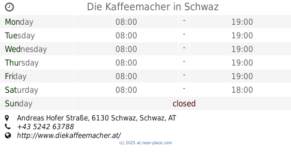
Die Kaffeemacher
10, Andreas Hofer Straße, Schwaz
Cafe
read more
4.062 km
Franz-Josef-Stüberl
Franz-Josef-Straße 19, Schwaz
Cafe
read more
4.062 km
Wolfgang Reiter
Franz-Josef-Straße 19, Schwaz
Cafe
read more
4.175 km
Mc Cafe
Industriestraße 7, Vomp
Cafe
read more
4.228 km
Cafe s'Schulgassl
Tannenberggasse 13, Schwaz
Cafe
read more
4.265 km
Cafe Lahnbachgasse
Marktstraße 19b, Schwaz
Cafe
read more
4.276 km
Sun´n More
Münchner Straße 3, Schwaz
Cafe
read more
4.508 km
Cafe zum Peerli
-Karl-Dorrek-Straße, Doktor-Karl-Dorrek-Straße, Schwaz
Cafe
read more
4.575 km
EZEB Bäckercafe Schwaz
Münchner Straße 34, Schwaz
Cafe
read more
4.722 km
Cafe Im LEBEN
Fiecht 3a, Fiecht
Cafe
read more
4.975 km
Sportcafe
Johannes-Messner-Weg 12, Schwaz
Cafe
read more
6.996 km
Buffet Bahnhof Fritzens-Wattens
Bahnhofplatz 1, Fritzens
Cafe
read more
13.583 km
Cafe-Konditorei Mayr
Walburga Schindl-Straße 15, Absam
Cafe
read more
📑
all categories
Accounting
Administrative area level 1
Administrative area level 2
Airport
Amusement park
Aquarium
Art gallery
Atm
Bakery
Bank
Bar
Beauty salon
Bicycle store
Book store
Bowling alley
Bus station
Cafe
Campground
Car dealer
Car rental
Car repair
Car wash
Casino
Cemetery
Church
City hall
Clothing store
Colloquial area
Convenience store
Country
Courthouse
Dentist
Department store
Doctor
Electrician
Electronics store
Embassy
Finance
Fire station
Florist
Food
Funeral home
Furniture store
Gas station
General contractor
Grocery or supermarket
Gym
Hair care
Hardware store
Health
Hindu Temple
Home goods store
Hospital
Insurance agency
Jewelry store
Laundry
Lawyer
Library
Light rail station
Liquor store
Local government office
Locality
Locksmith
Lodging
Meal delivery
Meal takeaway
Mosque
Movie rental
Movie theater
Moving company
Museum
Natural feature
Neighborhood
Night club
Painter
Park
Parking
Pet store
Pharmacy
Physiotherapist
Place of worship
Plumber
Point of interest
Police
Political
Post office
Premise
Real estate agency
Restaurant
Roofing contractor
Route
Rv park, camping
School
Shoe store
Shopping mall
Spa
Stadium
Storage
Store
Subpremise
Subway station
Supermarket
Synagogue
Taxi stand
Train station
Transit station
Travel agency
University
Veterinary care
Zoo
administrative area level 3
sublocality level 1
↑