Cafe nearby Forum Cafe
Austria
Cafe nearby Forum Cafe
Forum Cafe
Rathausplatz 4, Rum Austria
contacts phone
:
+43
Latitude:
47.2873013
, Longitude:
11.4588674
read more
nearest Cafe
123 m
Cafe Platzl
Dörfer Straße 9, Rum
Cafe
read more
317 m
Cafe-Pub F1
Finkenberg 1, Rum
Cafe
read more
1.105 km
Mc Cafe
Kaplanstraße 3, Rum
Cafe
read more
1.151 km
Cafe Turbo
Kaplanstraße 1, Rum
Cafe
read more
1.332 km
Cafe-Konditorei Schreiner
Stollenstraße 2, Thaur
Cafe
read more
1.503 km
Verwaltung Caffeteria Gastro GmbH
Serlesstraße 17, Rum
Cafe
read more
1.594 km
Moos Cafe
Moosgasse 13a, Thaur
Cafe
read more
1.667 km
Cafe Florian
Innstraße 46, Rum
Cafe
read more
1.752 km
Testarossacaffe
Innsbrucker Straße 83, Heiligkreuz
Cafe
read more
1.982 km
Cafe Monaco
Schützenstraße 29, Innsbruck
Cafe
read more
2.171 km
Bosin Gastro KG Kaffeerestaurant
Kugelfangweg 46, Innsbruck
Cafe
read more
2.634 km
Cafe Sandra
Trientlgasse 69, Innsbruck
Cafe
read more
2.748 km
KSUD BRATSTVO
Valiergasse 61, Innsbruck
Cafe
read more
2.942 km
Arnold & Hellebart OEG
Grabenweg 64, Innsbruck
Cafe
read more
3.004 km
Thaurer Alm
Halltal, Thaur
Cafe
read more
3.229 km
Cafe Top Spin
Radetzkystraße 41, Innsbruck
Cafe
read more
3.28 km
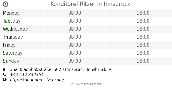
Konditorei Ritzer
Klappholzstraße 35a, Innsbruck
Cafe
read more
3.333 km
Reichenauerstüberl
Wörndlestraße 19, Innsbruck
Cafe
read more
3.358 km
Coffee Bar Innsbruck
Bleichenweg 18, Innsbruck
Cafe
read more
3.391 km
Bäckerei Ruetz
Leopold-Wedl-Weg 1, Innsbruck
Cafe
read more
3.461 km
Cafe Greif
Andechsstraße 85, Innsbruck
Cafe
read more
3.466 km
Rauch Juice Bar DEZ
Amraser-See-Straße 56a, Innsbruck
Cafe
read more
3.478 km
A Dopo
Amraser-See-Straße 56a, Innsbruck
Cafe
read more
3.57 km
Cafe-Pub Black-Horse
Andechsstraße 44, Innsbruck
Cafe
read more
3.865 km
Cafe Bambi
Schwindstraße 1, Innsbruck
Cafe
read more
📑
all categories
Accounting
Administrative area level 1
Administrative area level 2
Airport
Amusement park
Aquarium
Art gallery
Atm
Bakery
Bank
Bar
Beauty salon
Bicycle store
Book store
Bowling alley
Bus station
Cafe
Campground
Car dealer
Car rental
Car repair
Car wash
Casino
Cemetery
Church
City hall
Clothing store
Colloquial area
Convenience store
Country
Courthouse
Dentist
Department store
Doctor
Electrician
Electronics store
Embassy
Finance
Fire station
Florist
Food
Funeral home
Furniture store
Gas station
General contractor
Grocery or supermarket
Gym
Hair care
Hardware store
Health
Hindu Temple
Home goods store
Hospital
Insurance agency
Jewelry store
Laundry
Lawyer
Library
Light rail station
Liquor store
Local government office
Locality
Locksmith
Lodging
Meal delivery
Meal takeaway
Mosque
Movie rental
Movie theater
Moving company
Museum
Natural feature
Neighborhood
Night club
Painter
Park
Parking
Pet store
Pharmacy
Physiotherapist
Place of worship
Plumber
Point of interest
Police
Political
Post office
Premise
Real estate agency
Restaurant
Roofing contractor
Route
Rv park, camping
School
Shoe store
Shopping mall
Spa
Stadium
Storage
Store
Subpremise
Subway station
Supermarket
Synagogue
Taxi stand
Train station
Transit station
Travel agency
University
Veterinary care
Zoo
administrative area level 3
sublocality level 1
↑