Cafe nearby Jindrak Café Pöstlingberg
Austria
Cafe nearby Jindrak Café Pöstlingberg
Jindrak Café Pöstlingberg
Am Pöstlingberg 12, Linz Austria
contacts phone
:
+43
Latitude:
48.3235728
, Longitude:
14.2591756
read more
nearest Cafe
1.842 km
Cafe Tosca
Leonfeldner Straße 73, Linz
Cafe
read more
1.854 km
Cafe Eh
Hauptstraße 70, Linz
Cafe
read more
1.854 km
Cafe EH
Hauptplatz 70, Linz
Cafe
read more
1.86 km
Meisinger OEG
Hauptstraße 70, Linz
Cafe
read more
1.881 km
Café-Pub Gloria
Freistädter Straße 27, Linz
Cafe
read more
1.898 km
Inge's Bio Cafe
Hauptstraße 71, Linz
Cafe
read more
1.91 km
Hasenstall
Hauptstraße 62, Linz
Cafe
read more
1.952 km
WINWIN Linz-Urfahr
Hauptstraße 63, Linz
Cafe
read more
1.978 km
Feenwolke & Zuckerguss
Hauptstraße 59, Linz
Cafe
read more
2.019 km
Mein Café Hofbauer
Hauptstraße 46, Linz
Cafe
read more
2.032 km
Cafe Giuliano
Blütenstraße, Linz
Cafe
read more
2.042 km
Konditorei Jindrak | Filiale Lentia City
Blütenstraße 11, Linz
Cafe
read more
2.042 km
Konditoreicafe Jindrak
Blütenstraße 11, Linz
Cafe
read more
2.056 km
Urfahranerl
Peuerbachstraße 9, Linz
Cafe
read more
2.066 km
Cafe Plank
Hauptstraße 47, Linz
Cafe
read more
2.266 km
Josef Ruscic
Schulstraße 9, Linz
Cafe
read more
2.643 km
Pura Vida
Obere Donaulände 11, Linz
Cafe
read more
2.651 km
Eva Maria Wagner-Unter
Tummelplatz 10, Linz
Cafe
read more
2.661 km
Nachtschwärmer
Hofberg 4, Linz
Cafe
read more
2.673 km
Schatzeder Gesellschaft m.b.H.
Hofberg 6, Linz
Cafe
read more
2.71 km
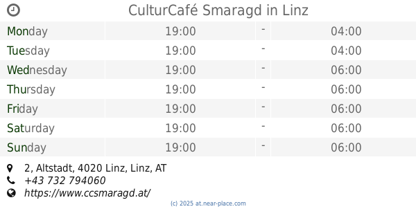
CulturCafé Smaragd
Altstadt 2, Linz
Cafe
read more
2.721 km
Walter König
Hofberg 11, Linz
Cafe
read more
2.721 km
Johann Zöttl
Hofgasse 14, Linz
Cafe
read more
2.784 km
Cafe Desperado
Hofgasse 1, Linz
Cafe
read more
2.784 km
Oliver Dangl
Hofgasse 1, Linz
Cafe
read more
📑
all categories
Accounting
Administrative area level 1
Administrative area level 2
Airport
Amusement park
Aquarium
Art gallery
Atm
Bakery
Bank
Bar
Beauty salon
Bicycle store
Book store
Bowling alley
Bus station
Cafe
Campground
Car dealer
Car rental
Car repair
Car wash
Casino
Cemetery
Church
City hall
Clothing store
Colloquial area
Convenience store
Country
Courthouse
Dentist
Department store
Doctor
Electrician
Electronics store
Embassy
Finance
Fire station
Florist
Food
Funeral home
Furniture store
Gas station
General contractor
Grocery or supermarket
Gym
Hair care
Hardware store
Health
Hindu Temple
Home goods store
Hospital
Insurance agency
Jewelry store
Laundry
Lawyer
Library
Light rail station
Liquor store
Local government office
Locality
Locksmith
Lodging
Meal delivery
Meal takeaway
Mosque
Movie rental
Movie theater
Moving company
Museum
Natural feature
Neighborhood
Night club
Painter
Park
Parking
Pet store
Pharmacy
Physiotherapist
Place of worship
Plumber
Point of interest
Police
Political
Post office
Premise
Real estate agency
Restaurant
Roofing contractor
Route
Rv park, camping
School
Shoe store
Shopping mall
Spa
Stadium
Storage
Store
Subpremise
Subway station
Supermarket
Synagogue
Taxi stand
Train station
Transit station
Travel agency
University
Veterinary care
Zoo
administrative area level 3
sublocality level 1
↑