Cafe nearby Wittelsbach Cafe
Austria
Cafe nearby Wittelsbach Cafe
Wittelsbach Cafe
Wittelsbachstraße 2, Wien Austria
contacts phone
:
+43
Latitude:
48.2058481
, Longitude:
16.3983077
read more
nearest Cafe
263 m
Café Zartl
Rasumofskygasse 7, Wien
Cafe
read more
383 m
Terrassencafe im Hundertwasserhaus
Kegelgasse 36-38, Wien
Cafe
read more
386 m
Speisen & Getränke
Kegelgasse 33, Wien
Cafe
read more
402 m
Ströck
Löwengasse 39, Wien
Cafe
read more
642 m
Il Gelato
オーストリア, Löwengasse 23, Vienna
Cafe
read more
671 m
Pappa e Ciccia
Landstraßer Hauptstraße 51, Wien
Cafe
read more
673 m
cafe kunst haus
Dampfschiffstraße, Wien
Cafe
read more
700 m
Eduscho (Austria) GmbH
Landstraßer Hauptstraße 75-77, Wien
Cafe
read more
715 m
Monika Vilimek
Landstraßer Hauptstraße 79, Wien
Cafe
read more
723 m
Cafe Venus
Erdbergstraße 55, Wien
Cafe
read more
739 m
Zum Konstantineck
Prater, Hauptallee 125b, Wien
Cafe
read more
777 m
STAMM
Sechskrügelgasse 1, Wien
Cafe
read more
780 m
Tauber Gastronomie GmbH
Landstraßer Hauptstraße 99, Wien
Cafe
read more
828 m
Segafredo Ristretto Galleria
Landstraßer Hauptstraße 99, Wien
Cafe
read more
836 m
Cafe Jury
Landstraßer Hauptstraße 6, Wien
Cafe
read more
846 m
Cafe Gmiatliches Eck
Keinergasse 4, Wien
Cafe
read more
846 m
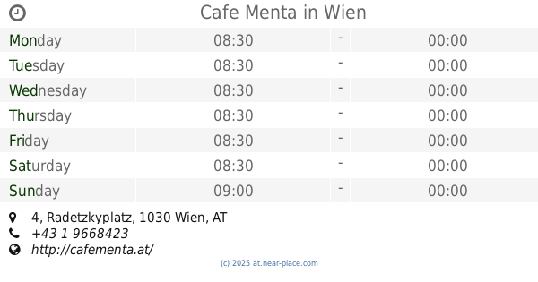
Cafe Menta
Radetzkyplatz 4, Wien
Cafe
read more
850 m
Laniato - Das Wiener Wollcafé
Beatrixgasse 4, Wien
Cafe
read more
898 m
Christine Kuntscher
Radetzkystraße 13, Wien
Cafe
read more
901 m
Mr. Heinz Harl
Invalidenstraße 2, Wien
Cafe
read more
924 m
Eis-Treff
Landstraßer Hauptstraße 99-101, Wien
Cafe
read more
931 m
Cafe Malipop
Ungargasse 10, Wien
Cafe
read more
951 m
Cafe Caramel
Invalidenstraße 13, Wien
Cafe
read more
962 m
Café LAZO
Hainburger Straße 66, Wien
Cafe
read more
1.393 km
Cafe Wettpoint
Praterstraße 36, Wien
Cafe
read more
📑
all categories
Accounting
Administrative area level 1
Administrative area level 2
Airport
Amusement park
Aquarium
Art gallery
Atm
Bakery
Bank
Bar
Beauty salon
Bicycle store
Book store
Bowling alley
Bus station
Cafe
Campground
Car dealer
Car rental
Car repair
Car wash
Casino
Cemetery
Church
City hall
Clothing store
Colloquial area
Convenience store
Country
Courthouse
Dentist
Department store
Doctor
Electrician
Electronics store
Embassy
Finance
Fire station
Florist
Food
Funeral home
Furniture store
Gas station
General contractor
Grocery or supermarket
Gym
Hair care
Hardware store
Health
Hindu Temple
Home goods store
Hospital
Insurance agency
Jewelry store
Laundry
Lawyer
Library
Light rail station
Liquor store
Local government office
Locality
Locksmith
Lodging
Meal delivery
Meal takeaway
Mosque
Movie rental
Movie theater
Moving company
Museum
Natural feature
Neighborhood
Night club
Painter
Park
Parking
Pet store
Pharmacy
Physiotherapist
Place of worship
Plumber
Point of interest
Police
Political
Post office
Premise
Real estate agency
Restaurant
Roofing contractor
Route
Rv park, camping
School
Shoe store
Shopping mall
Spa
Stadium
Storage
Store
Subpremise
Subway station
Supermarket
Synagogue
Taxi stand
Train station
Transit station
Travel agency
University
Veterinary care
Zoo
administrative area level 3
sublocality level 1
↑