Campground nearby Sonnensee Camping
Austria
Campground nearby Sonnensee Camping
Sonnensee Camping
45, Auenstrasse, 9451, Oberriet, Rheintal, CH Szwajcaria
contacts phone
:
+41 71 755 21 35
website:
www.sonnensee.ch
Latitude:
47.3620274
, Longitude:
9.6112991
larger map & directions
read more
nearest Campground
1.048 km
Campingplatz Baggersee
Baggerseestrasse 1, Oberriet
Campground
read more
5.016 km
Strandbad Diepoldsau
Strandbad 1468, Diepoldsau
Campground
read more
6.463 km
Wohnwagenplatz
Altstätten
Campground
read more
10.476 km
Camping Bruggerhorn
Strandbadstrasse, Sankt Margrethen
Campground
read more
11.733 km
Camping Dornbirn
Gütlestraße 15, Dornbirn
Campground
read more
11.779 km
Waldcamping Feldkirch
Stadionstraße 9, Feldkirch
Campground
read more
13.183 km
Campingplatz Am Buechberg
Buechbergstrasse 27, Thal
Campground
read more
14.81 km
Campingplatz Idyll
Mennstrasse 2, Thal
Campground
read more
15.137 km
Camping Rohrspitz Salzmann
Rohr 1, Fußach
Campground
read more
15.137 km
Rohrspitz Yachting Salzmann GmbH
Rohr 1, Fußach
Campground
read more
15.137 km
Campingplatz Rohrspitz Salzmann
Rohr 1, Fußach
Campground
read more
17.215 km
ne and baz austria
Bregenz
Campground
read more
17.317 km
Camping Weiss
4, Brachsenweg, Bregenz
Campground
read more
17.827 km
Camping Gasthof Lamm
Mehrerauerstraße 51, Bregenz
Campground
read more
20.905 km
Fewo Morik
Landstraße 10, Nenzing
Campground
read more
23.524 km
Campingplatz Schnell
Seestraße 32, Nonnenhorn
Campground
read more
23.524 km
Ottilie Schwarz
Seestraße 32, Nonnenhorn
Campground
read more
24.459 km
Camping Grosswalsertal
Plazera 21, Raggal
Campground
read more
25.714 km
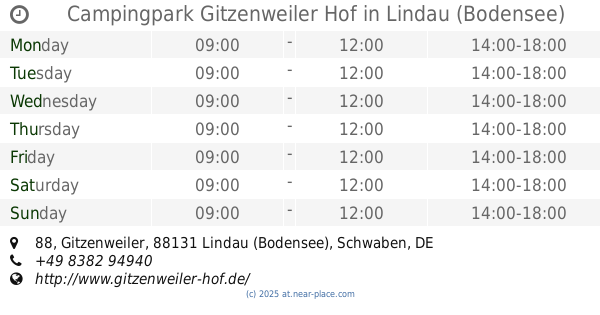
Campingpark Gitzenweiler Hof
Gitzenweiler 88, Lindau (Bodensee)
Campground
read more
25.765 km
Campingplatz Lindau
Gitzenweiler 88, Lindau (Bodensee)
Campground
read more
25.943 km
Campingpark Gitzenweiler Hof 2
Lindau (Bodensee)
Campground
read more
25.975 km
Panorama Camping Sonnenberg
Hinteroferst 12, Nüziders
Campground
read more
26.238 km
Hotel Burtschahof
Tschengla 46, Bürserberg
Campground
read more
28.467 km
Auhof Camping
Aulandweg 5, Bürs
Campground
read more
28.502 km
Klaus Tschugmell
Aulandweg 5, Bürs
Campground
read more
📑
all categories
Accounting
Administrative area level 1
Administrative area level 2
Airport
Amusement park
Aquarium
Art gallery
Atm
Bakery
Bank
Bar
Beauty salon
Bicycle store
Book store
Bowling alley
Bus station
Cafe
Campground
Car dealer
Car rental
Car repair
Car wash
Casino
Cemetery
Church
City hall
Clothing store
Colloquial area
Convenience store
Country
Courthouse
Dentist
Department store
Doctor
Electrician
Electronics store
Embassy
Finance
Fire station
Florist
Food
Funeral home
Furniture store
Gas station
General contractor
Grocery or supermarket
Gym
Hair care
Hardware store
Health
Hindu Temple
Home goods store
Hospital
Insurance agency
Jewelry store
Laundry
Lawyer
Library
Light rail station
Liquor store
Local government office
Locality
Locksmith
Lodging
Meal delivery
Meal takeaway
Mosque
Movie rental
Movie theater
Moving company
Museum
Natural feature
Neighborhood
Night club
Painter
Park
Parking
Pet store
Pharmacy
Physiotherapist
Place of worship
Plumber
Point of interest
Police
Political
Post office
Premise
Real estate agency
Restaurant
Roofing contractor
Route
Rv park, camping
School
Shoe store
Shopping mall
Spa
Stadium
Storage
Store
Subpremise
Subway station
Supermarket
Synagogue
Taxi stand
Train station
Transit station
Travel agency
University
Veterinary care
Zoo
administrative area level 3
sublocality level 1
↑