Cemetery nearby Friedhof Korneuburg
Austria
Cemetery nearby Friedhof Korneuburg
Friedhof Korneuburg
Stockerauer Straße 77, Korneuburg Austria
contacts phone
:
+43
Latitude:
48.3506105
, Longitude:
16.3235295
read more
nearest Cemetery
2.93 km
Friedhof Kritzendorf
Vitusplatz, Klosterneuburg
Cemetery
read more
3.576 km
Friedhof Untere Stadt, "Martinsfriedhof"
Jakobgasse 7, Klosterneuburg
Cemetery
read more
3.599 km
Friedhof Klosterneuburg - Unterer Stadtfriedhof
Martinstraße 94, Klosterneuburg
Cemetery
read more
3.599 km
Cemetery Klosterneuburg - Lower Town cemetery
Martinstraße 94, Klosterneuburg
Cemetery
read more
5.289 km
Friedhof Klein Engersdorf
Kirchenweg 79, Hagenbrunn
Cemetery
read more
8.575 km
Kahlenberger Friedhof (Josefsdorfer Friedhof)
Döbling
Cemetery
read more
8.978 km
Friedhof Kahlenbergerdorf
Willibald-Fischer-Weg, Wien
Cemetery
read more
9.655 km
Friedhof Jedlesee
Audorfgasse 47, Wien
Cemetery
read more
9.655 km
Friedhof Jedlesee
Vienna
Cemetery
read more
9.77 km
Friedhof St.Andrä
Tullnerstraße 30, Sankt Andrä-Wördern
Cemetery
read more
10.202 km
Heiligenstädter Friedhof
Nussdorf, Wien-Döbling
Cemetery
read more
10.285 km
Friedhof Nußdorf
Bécs
Cemetery
read more
10.758 km
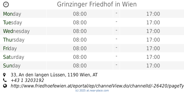
Grinzinger Friedhof
An den langen Lüssen 33, Wien
Cemetery
read more
11.284 km
Friedhoefe Wien
Nottebohmstraße 51, Wien
Cemetery
read more
11.879 km
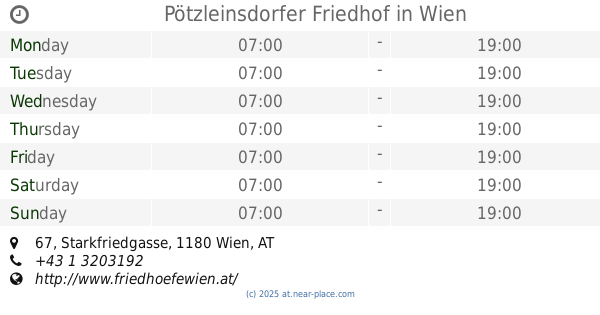
Pötzleinsdorfer Friedhof
Starkfriedgasse 67, Wien
Cemetery
read more
13.274 km
Gersthof Cemetery
Möhnergasse 1, Wien
Cemetery
read more
13.676 km
Dornbach Cemetery
Alszeile 28, Wien
Cemetery
read more
13.698 km
Friedhof Dornbach
Alszeile 28, Wien
Cemetery
read more
13.935 km
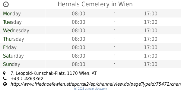
Hernals Cemetery
Leopold-Kunschak-Platz 7, Wien
Cemetery
read more
14.279 km
Stein-Schindler
Zissersdorf 37, Zissersdorf
Cemetery
read more
14.413 km
Jüdischer Friedhof Rossau
Alsergrund
Cemetery
read more
14.435 km
Jüdischer Friedhof Seegasse
Seegasse 9, Wien
Cemetery
read more
14.7 km
Tierfriedhof Waldesruh
Sierndorf
Cemetery
read more
16.702 km
Friedhof Hirschstetten
Quadenstraße 11, Wien
Cemetery
read more
16.821 km
Antares Tierbestattungen Hubert Malissa
Stadlauer Straße 38, Wien
Cemetery
read more
📑
all categories
Accounting
Administrative area level 1
Administrative area level 2
Airport
Amusement park
Aquarium
Art gallery
Atm
Bakery
Bank
Bar
Beauty salon
Bicycle store
Book store
Bowling alley
Bus station
Cafe
Campground
Car dealer
Car rental
Car repair
Car wash
Casino
Cemetery
Church
City hall
Clothing store
Colloquial area
Convenience store
Country
Courthouse
Dentist
Department store
Doctor
Electrician
Electronics store
Embassy
Finance
Fire station
Florist
Food
Funeral home
Furniture store
Gas station
General contractor
Grocery or supermarket
Gym
Hair care
Hardware store
Health
Hindu Temple
Home goods store
Hospital
Insurance agency
Jewelry store
Laundry
Lawyer
Library
Light rail station
Liquor store
Local government office
Locality
Locksmith
Lodging
Meal delivery
Meal takeaway
Mosque
Movie rental
Movie theater
Moving company
Museum
Natural feature
Neighborhood
Night club
Painter
Park
Parking
Pet store
Pharmacy
Physiotherapist
Place of worship
Plumber
Point of interest
Police
Political
Post office
Premise
Real estate agency
Restaurant
Roofing contractor
Route
Rv park, camping
School
Shoe store
Shopping mall
Spa
Stadium
Storage
Store
Subpremise
Subway station
Supermarket
Synagogue
Taxi stand
Train station
Transit station
Travel agency
University
Veterinary care
Zoo
administrative area level 3
sublocality level 1
↑