Cemetery nearby Kattauer Friedhof
Coronavirus disease (COVID-19) Situation
confirmed cases
6081287
deaths
22542
Austria
Cemetery nearby Kattauer Friedhof
Kattauer Friedhof
Austria Austria
contacts phone
:
+43
Latitude:
48.6716514
, Longitude:
15.8058034
read more
nearest Cemetery
6.15 km
Friedhof
Гемайнде, Meiseldorf
Cemetery
read more
6.574 km
Cimitero Militare Italiano Sigmundsherberg
Kainreith 76, Kainreith
Cemetery
read more
8.072 km
Friedhof Walkenstein
Walkenstein 45, Walkenstein
Cemetery
read more
11.41 km
namenlos
Prager Straße 43, Horn
Cemetery
read more
11.438 km
Steinmetz Erwin Zechmeister GmbH
Prager Straße 45, Horn
Cemetery
read more
11.691 km
Советское воинское захоронение
Гемайнде, Horn
Cemetery
read more
12.562 km
Friedhof Weitersfeld
Österreich
Cemetery
read more
13.816 km
Кладбище
Gemeinde Gars am Kamp
Cemetery
read more
14.158 km
Friedhof Gars / Thunau
Am Schloßberg 24, Thunau am Kamp
Cemetery
read more
14.954 km
Friedhof Pleißing
Österreich
Cemetery
read more
17.966 km
Friedhof Fahndorf
Österreich
Cemetery
read more
19.899 km
Friedhof Schöngrabern
Schöngrabern 83, Schöngrabern
Cemetery
read more
23.184 km
Friedhof Sonnberg
Sonnberg
Cemetery
read more
24.102 km
Jüdischer Friedhof Hollabrunn
Steinfeldgasse 360, Gemeinde Hollabrunn
Cemetery
read more
24.266 km
Friedhofsverwaltung
Marchatsteig 389, Gemeinde Hollabrunn
Cemetery
read more
24.321 km
Советское воинское захоронение
Jahnstraße 2020, Gemeinde Hollabrunn
Cemetery
read more
24.374 km
Friedhof Hollabrunn
Hollabrunn
Cemetery
read more
24.374 km
Friedhof Hollabrunn
Gemeinde Hollabrunn
Cemetery
read more
27.957 km
Leopold Gräser
Gewerbepark 5, Gföhl
Cemetery
read more
36.08 km
Friedhof Mautern
Mautern an der Donau
Cemetery
read more
53.922 km
Friedhof Klosterneuburg - Unterer Stadtfriedhof
Martinstraße 94, Klosterneuburg
Cemetery
read more
59.736 km
Friedhof Kahlenbergerdorf
Willibald-Fischer-Weg, Wien
Cemetery
read more
60.671 km
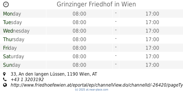
Grinzinger Friedhof
An den langen Lüssen 33, Wien
Cemetery
read more
64.568 km
Jüdischer Friedhof Rossau
Alsergrund
Cemetery
read more
64.596 km
Jüdischer Friedhof Seegasse
Seegasse 9, Wien
Cemetery
read more
📑
all categories
Accounting
Administrative area level 1
Administrative area level 2
Airport
Amusement park
Aquarium
Art gallery
Atm
Bakery
Bank
Bar
Beauty salon
Bicycle store
Book store
Bowling alley
Bus station
Cafe
Campground
Car dealer
Car rental
Car repair
Car wash
Casino
Cemetery
Church
City hall
Clothing store
Colloquial area
Convenience store
Country
Courthouse
Dentist
Department store
Doctor
Electrician
Electronics store
Embassy
Finance
Fire station
Florist
Food
Funeral home
Furniture store
Gas station
General contractor
Grocery or supermarket
Gym
Hair care
Hardware store
Health
Hindu Temple
Home goods store
Hospital
Insurance agency
Jewelry store
Laundry
Lawyer
Library
Light rail station
Liquor store
Local government office
Locality
Locksmith
Lodging
Meal delivery
Meal takeaway
Mosque
Movie rental
Movie theater
Moving company
Museum
Natural feature
Neighborhood
Night club
Painter
Park
Parking
Pet store
Pharmacy
Physiotherapist
Place of worship
Plumber
Point of interest
Police
Political
Post office
Premise
Real estate agency
Restaurant
Roofing contractor
Route
Rv park, camping
School
Shoe store
Shopping mall
Spa
Stadium
Storage
Store
Subpremise
Subway station
Supermarket
Synagogue
Taxi stand
Train station
Transit station
Travel agency
University
Veterinary care
Zoo
administrative area level 3
sublocality level 1
↑