Kirke i nærheden Neuapostolische Kirche Österreich, Gemeinde Linz/Urfahr
Østrig
Kirke i nærheden Neuapostolische Kirche Österreich, Gemeinde Linz/Urfahr
Neuapostolische Kirche Österreich, Gemeinde Linz/Urfahr
Rudolfstraße 36, Linz Austria
kontakter telefon
:
+43
Latitude:
48.3100367
, Longitude:
14.2791161
læs mere
nærmeste Kirke
269 m
Rieseneder
Landgutstraße 22, Linz
Kirke
læs mere
423 m
ERLEBNIS HÖRSTRASSE
Schulstraße 6, Linz
Kirke
læs mere
441 m
Stadtpfarre Urfahr
Schulstraße 4, Linz
Kirke
læs mere
441 m
Stadtpfarrkirche Urfahr St. Josef
Schulstraße 4, Linz
Kirke
læs mere
522 m
Neuapostolische Kirche Österreich, Gemeinde Linz/Urfahr
Hauptstraße 62, Linz
Kirke
læs mere
611 m
Martinskirche
Linz
Kirke
læs mere
695 m
Gustav Adolf Kirche
Freistädter Straße 10, Linz
Kirke
læs mere
706 m
Mariannhiller Mission
Promenade 30, Linz
Kirke
læs mere
751 m
Evangelische Kirche
Urfahr, 4040
Kirke
læs mere
793 m
Minoritenkirche
Linz
Kirke
læs mere
798 m
Minoritenkirche
Promenade 24, Linz
Kirke
læs mere
823 m
Pfarrkirche Linz
Pfarrplatz 20, Linz
Kirke
læs mere
856 m
Alter Dom
Domgasse 3, Linz
Kirke
læs mere
866 m
Ignatiusdom
Domgasse 3, Linz
Kirke
læs mere
920 m
Pfarre Christkönig - Friedenskirche
Wildbergstraße 30a, Linz
Kirke
læs mere
981 m
Altkatholisches Pfarramt
Fabrikstraße 10, Linz
Kirke
læs mere
981 m
Altkatholische Kirche Österreichs - Gemeinde Linz
Fabrikstraße 10, Linz
Kirke
læs mere
1.111 km
Diözese Linz Bischofshof
Herrenstraße 19, Linz
Kirke
læs mere
1.227 km
Karmelitenkirche
Landstraße 33, Linz
Kirke
læs mere
1.237 km
Loretto Gebetskreis Linz in der Krypta der Karmeliten
Harrachstraße 2, Linz
Kirke
læs mere
1.237 km
Krypta der Karmeliten Linz
Harrachstraße 2, Linz
Kirke
læs mere
1.24 km
Barbara Kapelle
Am Freinberg 4020, Linz
Kirke
læs mere
1.242 km
Karmelitenkonvent
Landstraße 33, Linz
Kirke
læs mere
1.251 km
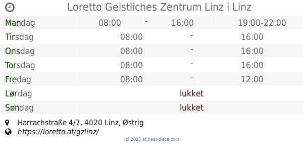
Loretto Geistliches Zentrum Linz
Harrachstraße 4/7, Linz
Kirke
læs mere
1.283 km
Krypta der Kamelitenkirche
Landstraße 33, Linz
Kirke
læs mere
📑
alle kategorier
Administrative område niveau 1
Administrative område niveau 2
Advokat
Akvarium
Ambassade
Apotek
Bageri
Bank
Bar
Begravelse hjem
Bibliotek
Bilforhandler
Bilreparationer
Bilvask
Biograf
Blikkenslager
Blomsterhandler
Bog butik
Bowlingbaner
Brandstation
Busstoppested
Butik
Bydel niveau 1
Cafe
Campingplads
Cykel butik
Dagligdags område
Dagligvarebutik
Dyrehandel
Dyrlægebehandling
Ejendomsmægler
Elektriker
Elektronik butik
Filmudlejning
Finansiere
Flyttefirma
Forlystelsespark
Forsikring agentur
Forudsætning
Fysioterapeut
Guldsmed
Gym
Hindu Temple
Hjem varer butik
Hospital
Hovedentreprenør
Hårpleje
Indkøbscenter
Isenkræmmer
Kasino
Kirke
Kirkegård
Kommunen
Kunstgalleri
Købmand eller supermarked
Land
Letbane station
Logi
Lokalitet
Lufthavn
Låsesmed
Læge
Mad
Maler
Metrostation
Moske
Museum
Måltid levering
Måltid takeaway
Møbelbutik
Nabolag
Natklub
Naturlige træk
Opbevaring
Parkere
Parkering
Pengeautomat
Politi
Politisk
Postkontor
Punkt af interesse
Regnskab
Rejsebureau
Restaurant
Retsbygning
Rute
Rv park, camping
Rådhus
Sko butik
Skole
Skønhedssalon
Spa
Stadion
Sted for tilbedelse
Stormagasin
Subpremise
Sundhed
Supermarked
Synagoge
Tagdækning entreprenør
Tandlæge
Tankstation
Taxaholdeplads
Togstation
Transit station
Tøjbutik
Universitet
Vasketøj
Vinhandel
Zoo
administrative område niveau 3
biludlejning
↑