Clothing store nearby Hus & Hus Handelsges.mbH
Austria
Clothing store nearby Hus & Hus Handelsges.mbH
Hus & Hus Handelsges.mbH
Praterstraße 32, Wien Østrig
contacts phone
:
+43
Latitude:
48.214415
, Longitude:
16.3844603
read more
nearest Clothing store
593 m
www.silviagattin.com / Bomex Handelsges.mbH
Hollandstraße 9, Wien
Clothing store
read more
666 m
Blaumax
Fleischmarkt 20, Wien
Clothing store
read more
675 m
Mrs. Elisabeth Burian
Stubenring 16, Wien
Clothing store
read more
774 m
Museums- Betriebsgesellschaft mbH
Krieglergasse 15, Wien
Clothing store
read more
797 m
Marionnaud
Rotenturmstraße 16-18, Wien
Clothing store
read more
798 m
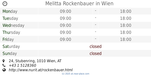
Melitta Rockenbauer
Stubenring 24, Wien
Clothing store
read more
819 m
Calzedonia
Rotenturmstraße 14, Wien-Innere Stadt
Clothing store
read more
850 m
ÖTK Österreichischer Touristenklub
Bäckerstraße 16, Wien
Clothing store
read more
865 m
Bogner
Lugeck 1-2, Wien
Clothing store
read more
870 m
Contrastshop.com
Salzgries 3, Wien
Clothing store
read more
870 m
Roj beer-brewery AG
Salzgries 3, Wien
Clothing store
read more
891 m
Hand Made Story
Lugeck 5, Wien
Clothing store
read more
944 m
Humana Secondhand
Löwengasse 37, Wien
Clothing store
read more
958 m
INDIE
Strobelgasse 2, Wien
Clothing store
read more
995 m
Das Neue Schwarz
Landskrongasse 1, Wien
Clothing store
read more
1.05 km
FIRIS
Bauernmarkt 9, Wien
Clothing store
read more
1.069 km
Alice
Wildpretmarkt 3, Wien
Clothing store
read more
1.106 km
Solebox Sneekers Store
Jasomirgottstraße 6, Wien
Clothing store
read more
1.118 km
COS
Bauernmarkt 2A, Wien
Clothing store
read more
1.152 km
NOVITA
Singerstraße 8, Wien
Clothing store
read more
1.178 km
Pelzsalon Jovanovic
Weihburggasse 9, Wien
Clothing store
read more
1.18 km
Zara
Stock-im-Eisen-Platz 4, Wien
Clothing store
read more
1.197 km
Dessous beim Graben
Graben 31, Wien
Clothing store
read more
1.231 km
Forever 21
Kärntner Straße 9, Wien
Clothing store
read more
1.3 km
Olsen Moden GmbH & Co Nfg KG
Kärntner Straße 19, Wien
Clothing store
read more
📑
all categories
Accounting
Administrative area level 1
Administrative area level 2
Airport
Amusement park
Aquarium
Art gallery
Atm
Bakery
Bank
Bar
Beauty salon
Bicycle store
Book store
Bowling alley
Bus station
Cafe
Campground
Car dealer
Car rental
Car repair
Car wash
Casino
Cemetery
Church
City hall
Clothing store
Colloquial area
Convenience store
Country
Courthouse
Dentist
Department store
Doctor
Electrician
Electronics store
Embassy
Finance
Fire station
Florist
Food
Funeral home
Furniture store
Gas station
General contractor
Grocery or supermarket
Gym
Hair care
Hardware store
Health
Hindu Temple
Home goods store
Hospital
Insurance agency
Jewelry store
Laundry
Lawyer
Library
Light rail station
Liquor store
Local government office
Locality
Locksmith
Lodging
Meal delivery
Meal takeaway
Mosque
Movie rental
Movie theater
Moving company
Museum
Natural feature
Neighborhood
Night club
Painter
Park
Parking
Pet store
Pharmacy
Physiotherapist
Place of worship
Plumber
Point of interest
Police
Political
Post office
Premise
Real estate agency
Restaurant
Roofing contractor
Route
Rv park, camping
School
Shoe store
Shopping mall
Spa
Stadium
Storage
Store
Subpremise
Subway station
Supermarket
Synagogue
Taxi stand
Train station
Transit station
Travel agency
University
Veterinary care
Zoo
administrative area level 3
sublocality level 1
↑