Florist nearby Blumenstube Dagi
Austria
Florist nearby Blumenstube Dagi
Blumenstube Dagi
Geiselbergstraße 27-31, Wien Austria
contacts phone
:
+43
Latitude:
48.1749521
, Longitude:
16.4034522
read more
nearest Florist
762 m
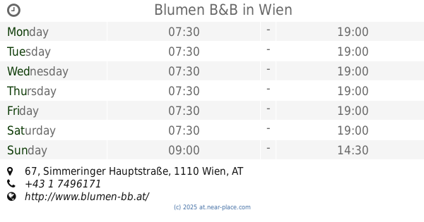
Blumen B&B
Simmeringer Hauptstraße 67, Wien
Florist
read more
804 m
Blütenzeit
Enkplatz 1, Wien
Florist
read more
834 m
Bonsaistudio Ebetshuber Wien´s ältester Bonsaifachhandel
Simmeringer Hauptstraße 93, Wien
Florist
read more
1.15 km
Blumen E. Wagner
Simmeringer Hauptstraße 108C, Wien
Florist
read more
1.464 km
Blumenboutique - Hydro Design
Friedrich-Hillegeist-Straße 1, Wien
Florist
read more
1.578 km
Ilviras Blumen
Guglgasse 6 (Gasometer A, 2. Stock), Wien
Florist
read more
1.625 km
Josef Diner
Unter der Kirche 5, Wien
Florist
read more
1.668 km
Blumen Vogler
Unter der Kirche 2, Wien
Florist
read more
1.825 km
Paul Schalko Gesellschaft m.b.H.
Patrubangasse 4, Wien
Florist
read more
1.827 km
Fair Lady - Blumen
Favoritenstraße 123, Wien
Florist
read more
1.884 km
Johanna Lockl
Antonsplatz 29, Wien
Florist
read more
1.941 km
Blumen Evelyn
Troststraße 5-9, Wien
Florist
read more
1.959 km
Inn Spirit e.U.
Troststraße 5-9, Wien
Florist
read more
2.009 km
Blumen Sittler e.U.
Viktor-Adler-Markt 15, Wien
Florist
read more
2.024 km
Blumen B & B
Fasangasse 55, Wien
Florist
read more
2.245 km
Blumen Loan
Quellenplatz 9, Wien
Florist
read more
2.351 km
Blumen Mitzi
Hainburger Straße 68-70, Wien
Florist
read more
2.353 km
Flower Square
Am Hauptbahnhof 1, Wien
Florist
read more
2.386 km
Radojka Mikaric
Fruethstraße 5, Wien
Florist
read more
2.926 km
Blumen B&B
Raxstraße 6-8, Wien
Florist
read more
2.98 km
Blumen KUMHOFER
Neulinggasse 36, Wien
Florist
read more
3.011 km
Blumerie
Rennweg 13, Wien
Florist
read more
3.136 km
Blumen Christian
Rochusgasse 18, Wien
Florist
read more
3.361 km
Blumen Cara Bronold
Reisnerstraße 10, Wien
Florist
read more
3.723 km
Der Rosenkavalier
Kärntner Ring 9, Wien
Florist
read more
📑
all categories
Accounting
Administrative area level 1
Administrative area level 2
Airport
Amusement park
Aquarium
Art gallery
Atm
Bakery
Bank
Bar
Beauty salon
Bicycle store
Book store
Bowling alley
Bus station
Cafe
Campground
Car dealer
Car rental
Car repair
Car wash
Casino
Cemetery
Church
City hall
Clothing store
Colloquial area
Convenience store
Country
Courthouse
Dentist
Department store
Doctor
Electrician
Electronics store
Embassy
Finance
Fire station
Florist
Food
Funeral home
Furniture store
Gas station
General contractor
Grocery or supermarket
Gym
Hair care
Hardware store
Health
Hindu Temple
Home goods store
Hospital
Insurance agency
Jewelry store
Laundry
Lawyer
Library
Light rail station
Liquor store
Local government office
Locality
Locksmith
Lodging
Meal delivery
Meal takeaway
Mosque
Movie rental
Movie theater
Moving company
Museum
Natural feature
Neighborhood
Night club
Painter
Park
Parking
Pet store
Pharmacy
Physiotherapist
Place of worship
Plumber
Point of interest
Police
Political
Post office
Premise
Real estate agency
Restaurant
Roofing contractor
Route
Rv park, camping
School
Shoe store
Shopping mall
Spa
Stadium
Storage
Store
Subpremise
Subway station
Supermarket
Synagogue
Taxi stand
Train station
Transit station
Travel agency
University
Veterinary care
Zoo
administrative area level 3
sublocality level 1
↑