Food nearby Water & Waste
Austria
Food nearby Water & Waste
Water & Waste
Lunzerstraße 85, Linz Österreich
contacts phone
:
+43
Latitude:
48.2693593
, Longitude:
14.3452842
read more
nearest Food
2.027 km
Caseli GmbH
voestalpine-Straße 3b, Linz
Food
read more
2.455 km
HEGUSA G.m.b.H
Stahlstraße 2-4, Linz
Food
read more
2.485 km
Borealis L.A.T GmbH
St.-Peter-Straße 25, Linz
Food
read more
3.135 km
LAKOBUST Handel
Heizhausstraße 35, Linz
Food
read more
3.455 km
Obst- Gemüse- und Südfrüchtengroßhandel Karl Samhaber GmbH & Co KG
Jaxstraße 11, Linz
Food
read more
4.122 km
Agrosolution GmbH & Co KG
Prinz-Eugen-Straße 23, Linz
Food
read more
4.366 km
DoN restaurant & catering gmbH
Europaplatz 1, Linz
Food
read more
4.824 km
Samenhandlung Bäck
Marktplatz 10, Linz
Food
read more
4.847 km
Wildberger- Amco Gastro Gruppe
Landwiedstraße 35, Linz
Food
read more
4.941 km
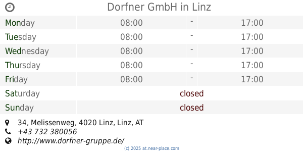
Dorfner GmbH
Melissenweg 34, Linz
Food
read more
5.108 km
Meeresbrise e.U.
Rainerstraße 12, Linz
Food
read more
5.14 km
Fest & Gast Catering
Bismarckstraße 8a, Linz
Food
read more
5.216 km
Gabriele Hofstetter
Landstraße 49, Linz
Food
read more
5.299 km
Kulinario Linz - Catering, Betriebsverpflegung, Sozialgastronomie
Seilerstätte 4, Linz
Food
read more
5.364 km
KULINARIO - Seilerstätten Küchenbetriebe GmbH
Seilerstätte 4, Linz
Food
read more
5.402 km
maurerbauer
Mozartsraße 7, Linz an der Donau
Food
read more
5.777 km
Karnerta GmbH
Holzstraße 5, Linz
Food
read more
5.808 km
Kulinarium
Steingasse 25, Linz
Food
read more
5.816 km
SaftundBrot
Schmidtorstraße 1, Linz
Food
read more
5.82 km
BARMAN - Ihr Mann für alle Feste
Promenade 25, Linz
Food
read more
5.899 km
Redoutensäle province of Upper Austria
Promenade 39, Linz
Food
read more
5.993 km
Prolactal GmbH
Ferdinand-Leihs-Straße 40, Hartberg
Food
read more
6.182 km
Sunside Catering
Ulmenweg 12, Ansfelden
Food
read more
6.418 km
Streatfood Austria - Guerilla Catering
Hauptstraße 4, Linz
Food
read more
6.606 km
Baumstriezel
Hinsenkampplatz 1, Linz
Food
read more
📑
all categories
Accounting
Administrative area level 1
Administrative area level 2
Airport
Amusement park
Aquarium
Art gallery
Atm
Bakery
Bank
Bar
Beauty salon
Bicycle store
Book store
Bowling alley
Bus station
Cafe
Campground
Car dealer
Car rental
Car repair
Car wash
Casino
Cemetery
Church
City hall
Clothing store
Colloquial area
Convenience store
Country
Courthouse
Dentist
Department store
Doctor
Electrician
Electronics store
Embassy
Finance
Fire station
Florist
Food
Funeral home
Furniture store
Gas station
General contractor
Grocery or supermarket
Gym
Hair care
Hardware store
Health
Hindu Temple
Home goods store
Hospital
Insurance agency
Jewelry store
Laundry
Lawyer
Library
Light rail station
Liquor store
Local government office
Locality
Locksmith
Lodging
Meal delivery
Meal takeaway
Mosque
Movie rental
Movie theater
Moving company
Museum
Natural feature
Neighborhood
Night club
Painter
Park
Parking
Pet store
Pharmacy
Physiotherapist
Place of worship
Plumber
Point of interest
Police
Political
Post office
Premise
Real estate agency
Restaurant
Roofing contractor
Route
Rv park, camping
School
Shoe store
Shopping mall
Spa
Stadium
Storage
Store
Subpremise
Subway station
Supermarket
Synagogue
Taxi stand
Train station
Transit station
Travel agency
University
Veterinary care
Zoo
administrative area level 3
sublocality level 1
↑