Gas station nearby IQ-Tankstelle KlotzOG
Austria
Gas station nearby IQ-Tankstelle KlotzOG
IQ-Tankstelle KlotzOG
Hauptstraße 36, Ried im Traunkreis Austria
contacts phone
:
+43
Latitude:
48.0257148
, Longitude:
14.0750245
read more
nearest Gas station
1.901 km
BP
Großendorf 82, Ried im Traunkreis
Gas station
read more
2.637 km
M-Oil
Grossendorf 85, Ried im Traunkreis
Gas station
read more
2.641 km
Autohof
Grossendorf 85, Ried im Traunkreis
Gas station
read more
3.411 km
Wölfl Ried im Traunkreis
Großendorf 92, Ried im Traunkreis
Gas station
read more
5.511 km
BP
Voralpenkreuz A8, Sattledt
Gas station
read more
5.941 km
BP
Sportplatzstraße 1, Sattledt
Gas station
read more
6.385 km
Shell
Solarstraße 2, Mayersdorf
Gas station
read more
8.102 km
Tankstelle Scheureder
Wollsberg 37, Wollsberg
Gas station
read more
9.085 km
Pink Tankstelle
Reitingerstraße 1, Steinhaus bei Wels
Gas station
read more
11.296 km
Diskont Seewirt
Steinhaus 54, Steinhaus bei Wels
Gas station
read more
11.317 km
Eckmair
Steinhaus 54, Steinhaus bei Wels
Gas station
read more
11.751 km
Lagerhaus Genol Tankstelle
Sattledterstraße 11, Fischlham
Gas station
read more
15.083 km
Ecodrom
Boschstraße 5a, Wels
Gas station
read more
15.215 km
FE-Trading GmbH (Diskont Tankstelle am Hofer Parkplatz)
Malvenstraße 3, Wels
Gas station
read more
15.24 km
IQ
Welser Straße 70, Gunskirchen
Gas station
read more
15.336 km
Heppner & Oberndorfer
Lastenstraße 11, Gunskirchen
Gas station
read more
15.377 km
Emin Bozkurt
Gunskirchener Straße 7, Wels
Gas station
read more
15.459 km
maxi.tank
Gunskirchener Straße 7, Wels
Gas station
read more
15.463 km
Emin Bozkurt
Gunskirchener Straße 1, Wels
Gas station
read more
15.558 km
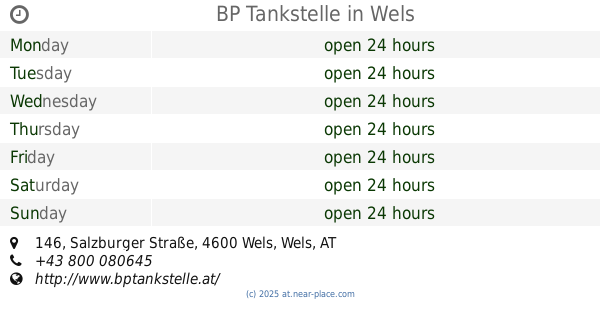
BP Tankstelle
Salzburger Straße 146, Wels
Gas station
read more
15.606 km
Wels Mazot
Salzburger Straße 226, Wels
Gas station
read more
15.614 km
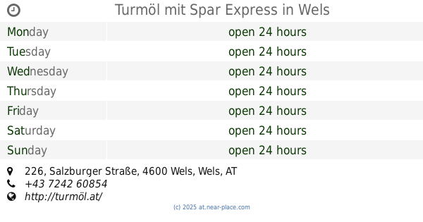
Turmöl mit Spar Express
Salzburger Straße 226, Wels
Gas station
read more
15.617 km
Shell
Salzburger Straße 224, Wels
Gas station
read more
15.84 km
Turmöl
Sipbach 10, Allhaming
Gas station
read more
17.495 km
Lagerhaus Genol Tankstelle
Steyrerstraße 41, Neuhofen an der Krems
Gas station
read more
📑
all categories
Accounting
Administrative area level 1
Administrative area level 2
Airport
Amusement park
Aquarium
Art gallery
Atm
Bakery
Bank
Bar
Beauty salon
Bicycle store
Book store
Bowling alley
Bus station
Cafe
Campground
Car dealer
Car rental
Car repair
Car wash
Casino
Cemetery
Church
City hall
Clothing store
Colloquial area
Convenience store
Country
Courthouse
Dentist
Department store
Doctor
Electrician
Electronics store
Embassy
Finance
Fire station
Florist
Food
Funeral home
Furniture store
Gas station
General contractor
Grocery or supermarket
Gym
Hair care
Hardware store
Health
Hindu Temple
Home goods store
Hospital
Insurance agency
Jewelry store
Laundry
Lawyer
Library
Light rail station
Liquor store
Local government office
Locality
Locksmith
Lodging
Meal delivery
Meal takeaway
Mosque
Movie rental
Movie theater
Moving company
Museum
Natural feature
Neighborhood
Night club
Painter
Park
Parking
Pet store
Pharmacy
Physiotherapist
Place of worship
Plumber
Point of interest
Police
Political
Post office
Premise
Real estate agency
Restaurant
Roofing contractor
Route
Rv park, camping
School
Shoe store
Shopping mall
Spa
Stadium
Storage
Store
Subpremise
Subway station
Supermarket
Synagogue
Taxi stand
Train station
Transit station
Travel agency
University
Veterinary care
Zoo
administrative area level 3
sublocality level 1
↑