Gas station nearby Jet
Austria
Gas station nearby Jet
Jet
99, Rheinstraße, 6971, Hard, Bregenz, AT Østrig
contacts phone
:
+43 5574 72366
Latitude:
47.4775324
, Longitude:
9.6793735
larger map & directions
read more
nearest Gas station
16 m
JET Tankstelle
Rheinstraße 99, Hard
Gas station
read more
1.882 km
OMV Tankstelle
Rheinstraße 24, Hard
Gas station
read more
1.929 km
BP
Harder Straße 84, Fußach
Gas station
read more
1.935 km
BP Tankstelle Maehr Ernst
Harder Straße 84, Fußach
Gas station
read more
2.082 km
Diskont Tankstelle
Rauhholzstraße 29, Hard
Gas station
read more
2.107 km
Eni
Rheinstraße 20, Hard
Gas station
read more
2.281 km
Avanti Tankstelle
Hofsteigstraße 85, Hard
Gas station
read more
2.972 km
Shell
Rheinstraße 88, Bregenz
Gas station
read more
3.292 km
Rüf Heizöle
Hauptstraße 38/40, Höchst
Gas station
read more
3.335 km
ESW Dieselkraftstoff
Hauptstraße 38, Höchst
Gas station
read more
3.34 km
Shell
Hauptstraße 32, Höchst
Gas station
read more
3.341 km
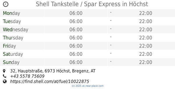
Shell Tankstelle / Spar Express
Hauptstraße 32, Höchst
Gas station
read more
3.69 km
Waldburger Eduard AG
Neudorfstrasse 48, Sankt Margrethen
Gas station
read more
3.972 km
Migrol Service
Grenzstrasse 31, Sankt Margrethen
Gas station
read more
3.974 km
Shell
Grenzstrasse 31, Sankt Margrethen
Gas station
read more
3.976 km
Agrola
Industriestrasse 43, Sankt Margrethen
Gas station
read more
4.085 km
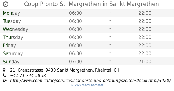
Coop Pronto St. Margrethen
Grenzstrasse 21, Sankt Margrethen
Gas station
read more
4.208 km
OMV Tankstelle
Arlbergstraße 135, Bregenz
Gas station
read more
4.521 km
Agip
Arlbergstraße 54, Bregenz
Gas station
read more
4.524 km
Eni Austria GmbH
Arlbergstraße 54, Bregenz
Gas station
read more
4.551 km
Günther Praxmarer
Arlbergstraße 54, Bregenz
Gas station
read more
4.598 km
Ruedi Rüssel gas station
Hauptstrasse 87, Sankt Margrethen
Gas station
read more
4.647 km
BP
Arlbergstraße 63, Bregenz
Gas station
read more
4.655 km
Eni
Rheinstraße 4, Bregenz
Gas station
read more
4.816 km
Bautrans GmbH Tankstelle
Senderstraße 16, Wolfurt
Gas station
read more
📑
all categories
Accounting
Administrative area level 1
Administrative area level 2
Airport
Amusement park
Aquarium
Art gallery
Atm
Bakery
Bank
Bar
Beauty salon
Bicycle store
Book store
Bowling alley
Bus station
Cafe
Campground
Car dealer
Car rental
Car repair
Car wash
Casino
Cemetery
Church
City hall
Clothing store
Colloquial area
Convenience store
Country
Courthouse
Dentist
Department store
Doctor
Electrician
Electronics store
Embassy
Finance
Fire station
Florist
Food
Funeral home
Furniture store
Gas station
General contractor
Grocery or supermarket
Gym
Hair care
Hardware store
Health
Hindu Temple
Home goods store
Hospital
Insurance agency
Jewelry store
Laundry
Lawyer
Library
Light rail station
Liquor store
Local government office
Locality
Locksmith
Lodging
Meal delivery
Meal takeaway
Mosque
Movie rental
Movie theater
Moving company
Museum
Natural feature
Neighborhood
Night club
Painter
Park
Parking
Pet store
Pharmacy
Physiotherapist
Place of worship
Plumber
Point of interest
Police
Political
Post office
Premise
Real estate agency
Restaurant
Roofing contractor
Route
Rv park, camping
School
Shoe store
Shopping mall
Spa
Stadium
Storage
Store
Subpremise
Subway station
Supermarket
Synagogue
Taxi stand
Train station
Transit station
Travel agency
University
Veterinary care
Zoo
administrative area level 3
sublocality level 1
↑