Gas station nearby Turmöl mit Spar express
Austria
Gas station nearby Turmöl mit Spar express
Turmöl mit Spar express
Alpenstraße 35, Anif Austria
contacts phone
:
+43
Latitude:
47.7481888
, Longitude:
13.0680593
read more
nearest Gas station
17 m
BP Austria Marketing GmbH
Alpenstraße 35, Anif
Gas station
read more
125 m
AP-Trading GmbH
Hellbrunnerstr 7, Anif
Gas station
read more
133 m
FE-Trading GmbH
Hellbrunnerstraße 7, Anif
Gas station
read more
173 m
Shell
Alpenstraße 2, Anif
Gas station
read more
1.512 km
tankpool24
Urstein Nord 75, Puch bei Hallein
Gas station
read more
1.514 km
AP-Trading GmbH - Urstein
Urstein Nord 75, Puch bei Hallein
Gas station
read more
1.518 km
A.P. TRADING - AustroPetrol
5412 bei, Urstein Nord 67, Puch bei Hallein
Gas station
read more
1.626 km
Robert Leitner
Halleiner Landesstraße 30, Elsbethen
Gas station
read more
1.746 km
eni
Salzachtalbundesstraße 105, Anif
Gas station
read more
1.897 km
LMEnergy
Salzachtalbundesstraße 111, Niederalm
Gas station
read more
1.971 km
Jet
Alpenstraße 165, Salzburg
Gas station
read more
1.981 km
JET Tankstelle
Alpenstraße 165, Salzburg
Gas station
read more
2.241 km
Eni ServiceStation
bei Österreich, Urstein Nord 15, Hallein
Gas station
read more
2.392 km
Parking
Ein/Ausfahrt 5020, Salzburg
Gas station
read more
2.714 km
BP Tankstelle Leikermoser Energiehandel GmbH
Johann-Herbst-Straße 15, Glasenbach - Elsbethen
Gas station
read more
3.107 km
OMV Tankstelle
Alpenstraße 106, Salzburg
Gas station
read more
3.125 km
OMV Tankstelle
Jakob-Auer-Straße 5, Salzburg
Gas station
read more
3.378 km
Eni
Halleiner Landesstraße 819, Puch bei Hallein
Gas station
read more
3.38 km
Genol Puch-Hallein
Halleiner Landesstraße 819
Gas station
read more
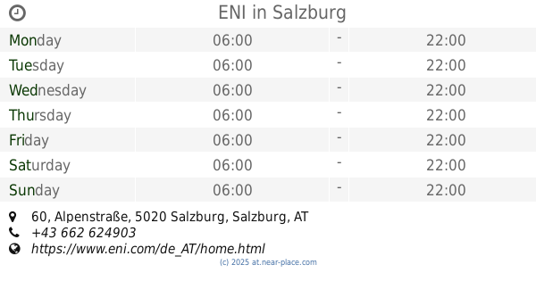
3.94 km
ENI
Alpenstraße 60, Salzburg
Gas station
read more
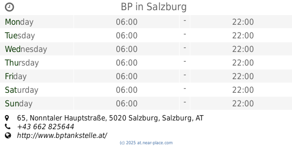
4.196 km
BP
Nonntaler Hauptstraße 65, Salzburg
Gas station
read more
4.486 km
OMV Tankstelle
Nonntaler Hauptstraße 53A, Salzburg
Gas station
read more
5.028 km
Shell
Alpenstraße 2, Salzburg
Gas station
read more
5.143 km
LMEnergy Tankstelle
Firmianstraße 42, Salzburg
Gas station
read more
10.745 km
BP
Lamprechtshausener Straße Bundesstraße, Lengfelden
Gas station
read more
📑
all categories
Accounting
Administrative area level 1
Administrative area level 2
Airport
Amusement park
Aquarium
Art gallery
Atm
Bakery
Bank
Bar
Beauty salon
Bicycle store
Book store
Bowling alley
Bus station
Cafe
Campground
Car dealer
Car rental
Car repair
Car wash
Casino
Cemetery
Church
City hall
Clothing store
Colloquial area
Convenience store
Country
Courthouse
Dentist
Department store
Doctor
Electrician
Electronics store
Embassy
Finance
Fire station
Florist
Food
Funeral home
Furniture store
Gas station
General contractor
Grocery or supermarket
Gym
Hair care
Hardware store
Health
Hindu Temple
Home goods store
Hospital
Insurance agency
Jewelry store
Laundry
Lawyer
Library
Light rail station
Liquor store
Local government office
Locality
Locksmith
Lodging
Meal delivery
Meal takeaway
Mosque
Movie rental
Movie theater
Moving company
Museum
Natural feature
Neighborhood
Night club
Painter
Park
Parking
Pet store
Pharmacy
Physiotherapist
Place of worship
Plumber
Point of interest
Police
Political
Post office
Premise
Real estate agency
Restaurant
Roofing contractor
Route
Rv park, camping
School
Shoe store
Shopping mall
Spa
Stadium
Storage
Store
Subpremise
Subway station
Supermarket
Synagogue
Taxi stand
Train station
Transit station
Travel agency
University
Veterinary care
Zoo
administrative area level 3
sublocality level 1
↑